
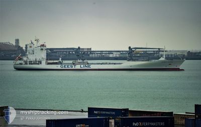
ATLANTIC KLIPPER
Reefer/Container Ship
Current Trip
| Time Travelled | 7 days |
|---|---|
| Remaining Time | 1 day |
| Distance Travelled | 2861.38 nm |
| Remaining Distance | 797.67 nm |
| AVG Speed | 14.5 Knopen |
| MAX Speed | 19.5 Knopen |
| AVG Wind | 14 knots |
| MAX Wind | 30.8 knots |
| MIN Temp | 6.7°C / 44.06°F |
| MAX Temp | 24.5°C / 76.1°F |
| Diepgang | 8.4 M |
| Positie ontvangen | 3 d geleden |
Current Position
| Lengtegraad | -32.31121° |
|---|---|
| Breedtegraat | 37.11315° |
| Status | Under way using engine |
| Snelheid | 15.9 Knopen |
| Koers | 232.6° |
| Gebied | North Atlantic Ocean |
| Station | T-AIS |
| Positie ontvangen | 3 d geleden |
Info
Information
The current position of ATLANTIC KLIPPER is in North Atlantic Ocean with coordinates 37.11315° / -32.31121° as reported on 2024-05-02 02:48 by AIS to our vessel tracker app. The vessel's current speed is 15.9 Knopen and is heading at the port of BRIDGETOWN. The estimated time of arrival as calculated by MyShipTracking vessel tracking app is 2024-05-07 08:07 LT
The vessel ATLANTIC KLIPPER (IMO: 9454761, MMSI: 245723000) is a Reefer/Container Ship that was built in 2011 ( 13 Jaar oud ). It's sailing under the flag of [NL] Netherlands.
In this page you can find informations about the vessels current position, last detected port calls, and current voyage information. If the vessels is not in coverage by AIS you will find the latest position.
The current position of ATLANTIC KLIPPER is detected by our AIS receivers and we are not responsible for the reliability of the data. The last position was recorded while the vessel was in Coverage by the Ais receivers of our vessel tracking app.
The current draught of ATLANTIC KLIPPER as reported by AIS is 8.4 meters
Weather
| Temperature | 24.5°C / 76.1°F |
|---|---|
| Wind Speed | 9 knots |
| Direction | 318° NW |
| Pressure | 1014.8 hPa |
| Humidity | 78.6 % |
| Cloud Coverage | 100 % |
Featured Company
Last Port Calls
| Port | Arrival | Departure | Time In Port |
|---|---|---|---|
| 2024-04-26 06:49 | 2024-04-27 13:17 | 1 d | |
| 2024-04-24 09:01 | 2024-04-25 17:31 | 1 d | |
| 2024-04-14 00:35 | 2024-04-15 09:33 | 1 d | |
| 2024-04-12 03:39 | 2024-04-12 11:57 | 8 h | |
| 2024-04-09 05:41 | 2024-04-11 05:14 | 1 d | |
| 2024-04-07 09:35 | 2024-04-07 22:45 | 13 h | |
| 2024-04-05 23:46 | 2024-04-06 04:28 | 4 h | |
| 2024-04-05 11:59 | 2024-04-05 18:27 | 6 h | |
| 2024-04-04 11:07 | 2024-04-05 00:27 | 13 h | |
| 2024-04-02 21:29 | 2024-04-03 11:24 | 13 h |
Most Visited Ports (Last year)
| Port | Arrivals | |
|---|---|---|
| 13 | ||
| 11 | ||
| 11 | ||
| 10 | ||
| 10 | ||
| 10 |
Last Trips
| Origin | Departure | Destination | Arrival | Distance | |
|---|---|---|---|---|---|
| 2024-04-25 19:31 | 2024-04-26 07:49 | 213.66 nm | |||
| 2024-04-15 05:33 | 2024-04-24 11:01 | 3999.60 nm | |||
| 2024-04-12 06:57 | 2024-04-13 20:35 | 655.23 nm | |||
| 2024-04-11 00:14 | 2024-04-11 22:39 | 279.74 nm | |||
| 2024-04-07 18:45 | 2024-04-09 00:41 | 616.67 nm | |||
| 2024-04-06 00:28 | 2024-04-07 05:35 | 491.24 nm | |||
| 2024-04-05 14:27 | 2024-04-05 19:46 | 67.44 nm | |||
| 2024-04-04 20:27 | 2024-04-05 07:59 | 207.72 nm | |||
| 2024-04-03 07:24 | 2024-04-04 07:07 | 163.34 nm | |||
| 2024-03-23 16:59 | 2024-04-02 17:29 | 4083.79 nm |
Events
| Tijd | Evenement | Details | Positie / Bestemming | Info |
|---|---|---|---|---|
| 2024-05-02 03:00 | Status Changed | Default Under way using engine |
37.07912 / -32.36675
BBBGI
|
Snelheid: 15.9 kn Koers: 232.6° |
| 2024-05-02 02:48 | Buitenbereik |
37.11315 / -32.31121
North Atlantic Ocean
BBBGI
|
Snelheid: 15.9 kn Koers: 232.6° |
|
| 2024-05-02 02:09 | Status Changed | Under way using engine Default |
37.21588 / -32.13988
BBBGI
|
Snelheid: 15.8 kn Koers: 234° |
| 2024-05-02 02:01 | Binnenbereik |
37.21423 / -32.14265
North Atlantic Ocean
BBBGI
|
Snelheid: 16.1 kn Koers: 233.4° |
|
| 2024-05-02 00:49 | Status Changed | Default Under way using engine |
37.43036 / -31.77801
BBBGI
|
Snelheid: 16.3 kn Koers: 232.9° |
| 2024-05-02 00:36 | Status Changed | Under way using engine Default |
37.46385 / -31.72099
BBBGI
|
Snelheid: 16.6 kn Koers: 232° |
| 2024-05-02 00:36 | Buitenbereik |
37.46385 / -31.72099
North Atlantic Ocean
BBBGI
|
Snelheid: 16.3 kn Koers: 232.9° |
|
| 2024-05-02 00:23 | Status Changed | Default Under way using engine |
37.50084 / -31.65910
BBBGI
|
Snelheid: 16.3 kn Koers: 234.4° |
| 2024-05-01 23:53 | Binnenbereik |
37.57965 / -31.52166
North Atlantic Ocean
BBBGI
|
Snelheid: 16.5 kn Koers: 234° |
|
| 2024-05-01 23:52 | Status Changed | Under way using engine Default |
37.58314 / -31.51569
BBBGI
|
Snelheid: 16.5 kn Koers: 234° |