
W NORTH
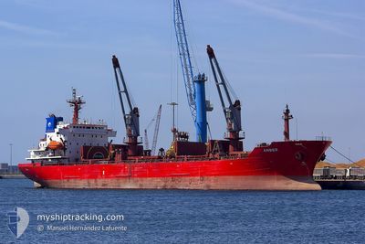
Oil/Chemical Tanker
Current Trip
| Trip Time | 1 day |
|---|---|
| Trip Distance | 475.88 nm |
| AVG Speed | 10.5 Noeuds |
| MAX Speed | 15.7 Noeuds |
| Tirant d eau | 5.1 m |
| AVG Wind | 9.4 knots |
| MAX Wind | 17 knots |
| MIN Temp | 10.8°C / 51.44°F |
| MAX Temp | 15.8°C / 60.44°F |
| Position reçue | 1 m depuis |
Current Position
| Longitude | -4.47344° |
|---|---|
| Latitude | 48.38102° |
| Etat | Moored |
| Vitesse | |
| Parcours | 188° |
| Zone | Celtic Sea |
| Station | T-AIS |
| Position reçue | 1 m depuis |
Info
Information
The current position of W NORTH is in Celtic Sea with coordinates 48.38102° / -4.47344° as reported on 2024-05-22 15:21 by AIS to our vessel tracker app. The vessel's current speed is 0 Noeuds and is currently inside the port of BREST.
The vessel W NORTH (IMO: 9272735, MMSI: 256585000) is a Oil/Chemical Tanker that was built in 2003 ( 21 Age ). It's sailing under the flag of [MT] Malta.
In this page you can find informations about the vessels current position, last detected port calls, and current voyage information. If the vessels is not in coverage by AIS you will find the latest position.
The current position of W NORTH is detected by our AIS receivers and we are not responsible for the reliability of the data. The last position was recorded while the vessel was in Coverage by the Ais receivers of our vessel tracking app.
The current draught of W NORTH as reported by AIS is 5.1 meters
Weather
| Temperature | 15.1°C / 59.18°F |
|---|---|
| Wind Speed | 12 knots |
| Direction | 290° WNW |
| Pressure | 1014 hPa |
| Humidity | 75.7 % |
| Cloud Coverage | 61 % |
Featured Company
Last Port Calls
| Port | Arrival | Departure | Time In Port |
|---|---|---|---|
| 2024-05-22 11:55 | |||
| 2024-05-20 04:43 | 2024-05-20 19:08 | 14 h | |
| 2024-05-18 15:32 | 2024-05-19 09:42 | 18 h | |
| 2024-05-12 17:41 | 2024-05-12 23:38 | 5 h | |
| 2024-05-09 08:00 | 2024-05-10 05:28 | 21 h | |
| 2024-04-27 06:32 | 2024-04-28 07:55 | 1 d | |
| 2024-04-18 10:17 | 2024-04-20 22:20 | 2 d | |
| 2024-04-13 17:33 | 2024-04-15 20:00 | 2 d | |
| 2024-04-07 13:54 | 2024-04-08 20:28 | 1 d | |
| 2024-04-02 09:05 | 2024-04-03 08:59 | 23 h |
Last Trips
| Origin | Departure | Destination | Arrival | Distance | |
|---|---|---|---|---|---|
| 2024-05-20 20:08 | 2024-05-22 13:55 | 475.88 nm | |||
| 2024-05-19 11:42 | 2024-05-20 05:43 | 130.15 nm | |||
| 2024-05-13 01:38 | 2024-05-18 17:32 | 1332.60 nm | |||
| 2024-05-10 07:28 | 2024-05-12 19:41 | 695.62 nm | |||
| 2024-04-28 09:55 | 2024-05-09 10:00 | 1215.58 nm | |||
| 2024-04-21 01:20 | 2024-04-27 08:32 | 1338.72 nm | |||
| 2024-04-16 00:00 | 2024-04-18 13:17 | 637.27 nm | |||
| 2024-04-08 23:28 | 2024-04-13 21:33 | 1353.84 nm | |||
| 2024-04-03 10:59 | 2024-04-07 16:54 | 1148.38 nm | |||
| 2024-03-29 21:52 | 2024-04-02 11:05 | 477.52 nm |
Events
| Heure | Evenement | Détails | Position/ Destination | Info |
|---|---|---|---|---|
| 2024-05-22 12:43 | Etat Changé | Moored Under way using engine |
48.38102 / -4.47343
[FR] BREST
|
Vitesse: Parcours: 188° |
| 2024-05-22 12:24 | Arret |
48.38094 / -4.47301
[FR] BREST
|
Vitesse: 0.3 kn Parcours: 182° |
|
| 2024-05-22 11:55 | Port d'arrivée |
|
48.37491 / -4.45969
[FR] BREST
|
Vitesse: 4.1 kn Parcours: 315° |
| 2024-05-22 08:25 | Etat Changé | Under way using engine Default |
48.31553 / -5.18340
GBLON >FRBES
|
Vitesse: 9.5 kn Parcours: 122° |
| 2024-05-22 08:25 | Dans la zone couverte |
48.31404 / -5.17919
Celtic Sea
GBLON >FRBES
|
Vitesse: 9.8 kn Parcours: 117.2° |
|
| 2024-05-22 01:41 | Etat Changé | Default Under way using engine |
49.00598 / -5.47311
GBLON >FRBES
|
Vitesse: 10.5 kn Parcours: 235.1° |
| 2024-05-22 01:35 | Hors de la zone couverte |
49.01479 / -5.45373
Celtic Sea
GBLON >FRBES
|
Vitesse: 10.5 kn Parcours: 235.1° |
|
| 2024-05-21 23:55 | Changement de zone | French part of the Celtic Sea French part of the English Channel |
49.17631 / -5.05828
Celtic Sea
GBLON >FRBES
|
Vitesse: 11.4 kn Parcours: 240.6° |
| 2024-05-21 21:11 | Etat Changé | Under way using engine Default |
49.46021 / -4.33700
GBLON >FRBES
|
Vitesse: 12.3 kn Parcours: 240° |
| 2024-05-21 21:10 | Etat Changé | Default Under way using engine |
49.46166 / -4.33322
GBLON >FRBES
|
Vitesse: 12.4 kn Parcours: 240° |