
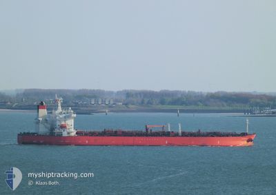
ST.NIKOLAI
Tanker
Current Trip
| Time Travelled | 8 days |
|---|---|
| Remaining Time | --- |
| Distance Travelled | 2226.13 nm |
| Remaining Distance | --- |
| AVG Speed | 11.9 Noeuds |
| MAX Speed | 16.5 Noeuds |
| AVG Wind | 10.4 knots |
| MAX Wind | 19.9 knots |
| MIN Temp | 9.7°C / 49.46°F |
| MAX Temp | 26.7°C / 80.06°F |
| Tirant d eau | 8.5 m |
| Position reçue | 6 m depuis |
Current Position
| Longitude | -93.62148° |
|---|---|
| Latitude | 29.40241° |
| Etat | At anchor |
| Vitesse | 0.1 Noeuds |
| Parcours | 135° |
| Zone | Gulf of Mexico |
| Station | T-AIS |
| Position reçue | 6 m depuis |
Info
Information
The current position of ST.NIKOLAI is in Gulf of Mexico with coordinates 29.40241° / -93.62148° as reported on 2024-05-06 18:21 by AIS to our vessel tracker app. The vessel's current speed is 0.1 Noeuds
The vessel ST.NIKOLAI (IMO: 9788485, MMSI: 563065100) is a Tanker It's sailing under the flag of [SG] Singapore.
In this page you can find informations about the vessels current position, last detected port calls, and current voyage information. If the vessels is not in coverage by AIS you will find the latest position.
The current position of ST.NIKOLAI is detected by our AIS receivers and we are not responsible for the reliability of the data. The last position was recorded while the vessel was in Coverage by the Ais receivers of our vessel tracking app.
The current draught of ST.NIKOLAI as reported by AIS is 8.5 meters
Weather
| Temperature | 24.2°C / 75.56°F |
|---|---|
| Wind Speed | 14 knots |
| Direction | 137° SE |
| Pressure | 1012 hPa |
| Humidity | 93.4 % |
| Cloud Coverage | 4 % |
Featured Company
Last Port Calls
| Port | Arrival | Departure | Time In Port |
|---|---|---|---|
| 2024-04-26 15:31 | 2024-04-28 01:08 | 1 d | |
| 2024-04-05 05:33 | 2024-04-05 14:30 | 8 h | |
| 2024-03-01 04:53 | 2024-03-03 00:41 | 1 d |
Events
| Heure | Evenement | Détails | Position/ Destination | Info |
|---|---|---|---|---|
| 2024-05-06 16:39 | Etat Changé | At anchor Default |
29.40244 / -93.62139
BEAUMONT
|
Vitesse: 0.1 kn Parcours: 147° |
| 2024-05-06 16:33 | Etat Changé | Default At anchor |
29.40257 / -93.62128
BEAUMONT
|
Vitesse: 0.2 kn Parcours: 134° |
| 2024-05-06 16:27 | Etat Changé | At anchor Default |
29.40244 / -93.62140
BEAUMONT
|
Vitesse: 0.2 kn Parcours: 141° |
| 2024-05-06 16:21 | Etat Changé | Default At anchor |
29.40248 / -93.62144
BEAUMONT
|
Vitesse: 0.1 kn Parcours: 144° |
| 2024-05-06 15:15 | Etat Changé | At anchor Default |
29.40248 / -93.62139
BEAUMONT
|
Vitesse: 0.1 kn Parcours: 134° |
| 2024-05-06 15:09 | Etat Changé | Default At anchor |
29.40240 / -93.62146
BEAUMONT
|
Vitesse: Parcours: 130° |
| 2024-05-06 15:03 | Etat Changé | At anchor Default |
29.40232 / -93.62158
BEAUMONT
|
Vitesse: 0.1 kn Parcours: 140° |
| 2024-05-06 14:57 | Etat Changé | Default At anchor |
29.40234 / -93.62149
BEAUMONT
|
Vitesse: 0.1 kn Parcours: 136° |
| 2024-05-06 14:03 | Etat Changé | At anchor Default |
29.40220 / -93.62163
BEAUMONT
|
Vitesse: Parcours: -1° |
| 2024-05-06 14:02 | Etat Changé | Default At anchor |
29.40167 / -93.62167
BEAUMONT
|
Vitesse: 0.1 kn Parcours: 130° |