
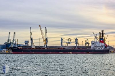
SAINT VASSILIOS
Bulk Carrier
Current Trip
| Time Travelled | 3 days |
|---|---|
| Remaining Time | --- |
| Distance Travelled | 911.17 nm |
| Remaining Distance | --- |
| AVG Speed | 12.6 Noeuds |
| MAX Speed | 14.9 Noeuds |
| AVG Wind | 11.3 knots |
| MAX Wind | 19 knots |
| MIN Temp | 21.6°C / 70.88°F |
| MAX Temp | 26.8°C / 80.24°F |
| Tirant d eau | 10.1 m |
| Position reçue | 1 h, 54 m depuis |
Current Position
| Longitude | -78.68441° |
|---|---|
| Latitude | 26.16601° |
| Etat | Under way using engine |
| Vitesse | 12.4 Noeuds |
| Parcours | 106.3° |
| Zone | North Atlantic Ocean |
| Station | T-AIS |
| Position reçue | 1 h, 54 m depuis |
Info
Information
The current position of SAINT VASSILIOS is in North Atlantic Ocean with coordinates 26.16601° / -78.68441° as reported on 2024-05-06 11:51 by AIS to our vessel tracker app. The vessel's current speed is 12.4 Noeuds and is heading at the port of CASABLANCA. The estimated time of arrival as calculated by MyShipTracking vessel tracking app is 2024-05-18 22:00 LT
The vessel SAINT VASSILIOS (IMO: 9486403, MMSI: 538004639) is a Bulk Carrier that was built in 2012 ( 12 Age ). It's sailing under the flag of [MH] Marshall Is.
In this page you can find informations about the vessels current position, last detected port calls, and current voyage information. If the vessels is not in coverage by AIS you will find the latest position.
The current position of SAINT VASSILIOS is detected by our AIS receivers and we are not responsible for the reliability of the data. The last position was recorded while the vessel was in Coverage by the Ais receivers of our vessel tracking app.
The current draught of SAINT VASSILIOS as reported by AIS is 10.1 meters
Weather
| Temperature | 24.4°C / 75.92°F |
|---|---|
| Wind Speed | 12 knots |
| Direction | 111° ESE |
| Pressure | 1017.8 hPa |
| Humidity | 72.5 % |
| Cloud Coverage | 9 % |
Featured Company
Last Port Calls
| Port | Arrival | Departure | Time In Port |
|---|---|---|---|
| 2024-05-03 07:46 | 2024-05-03 11:21 | 3 h | |
| 2024-04-26 10:45 | 2024-04-27 02:30 | 15 h | |
| 2024-04-17 18:11 | 2024-04-24 22:36 | 7 d | |
| 2024-03-26 13:19 | |||
| 2024-03-13 15:08 | 2024-03-13 15:52 | 43 m | |
| 2024-03-05 12:38 |
Most Visited Ports (Last year)
| Port | Arrivals | |
|---|---|---|
| 3 | ||
| 2 | ||
| 2 | ||
| 2 | ||
| 2 | ||
| 2 |
Last Trips
| Origin | Departure | Destination | Arrival | Distance | |
|---|---|---|---|---|---|
| 2024-04-26 21:30 | 2024-05-03 02:46 | 72.13 nm | |||
| 2024-04-24 17:36 | 2024-04-26 05:45 | 438.74 nm | |||
| 2024-03-26 14:19 | 2024-04-17 13:11 | 5359.68 nm | |||
| 2024-03-05 13:38 | 2024-03-13 16:08 | 910.61 nm |
Events
| Heure | Evenement | Détails | Position/ Destination | Info |
|---|---|---|---|---|
| 2024-05-06 12:09 | Etat Changé | Default Under way using engine |
26.14959 / -78.62186
MA CAS
|
Vitesse: 12.4 kn Parcours: 106.3° |
| 2024-05-06 11:51 | Etat Changé | Under way using engine Default |
26.16601 / -78.68441
MA CAS
|
Vitesse: 12.4 kn Parcours: 106° |
| 2024-05-06 11:51 | Hors de la zone couverte |
26.16601 / -78.68441
North Atlantic Ocean
MA CAS
|
Vitesse: 12.4 kn Parcours: 106.3° |
|
| 2024-05-06 11:50 | Etat Changé | Default Under way using engine |
26.16695 / -78.68804
MA CAS
|
Vitesse: 12.5 kn Parcours: 104.4° |
| 2024-05-06 11:05 | Etat Changé | Under way using engine Default |
26.20920 / -78.85336
MA CAS
|
Vitesse: 11.8 kn Parcours: 104° |
| 2024-05-06 10:31 | Etat Changé | Default Under way using engine |
26.22765 / -78.97481
MA CAS
|
Vitesse: 11.4 kn Parcours: 95.8° |
| 2024-05-06 09:41 | Etat Changé | Under way using engine Default |
26.22828 / -79.14486
MA CAS
|
Vitesse: 11.2 kn Parcours: 70° |
| 2024-05-06 08:53 | Etat Changé | Default Under way using engine |
26.14067 / -79.28900
MA CAS
|
Vitesse: 12.4 kn Parcours: 48.9° |
| 2024-05-06 08:33 | Etat Changé | Under way using engine Default |
26.09191 / -79.34352
MA CAS
|
Vitesse: 13.1 kn Parcours: 15° |
| 2024-05-06 08:33 | Dans la zone couverte |
26.09421 / -79.34250
North Atlantic Ocean
MA CAS
|
Vitesse: 12.9 kn Parcours: 23.5° |