
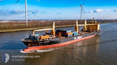
RED CEDAR
General Cargo
Current Trip
| Time Travelled | 1 day |
|---|---|
| Remaining Time | --- |
| Distance Travelled | 447.05 nm |
| Remaining Distance | --- |
| AVG Speed | 11.5 Noeuds |
| MAX Speed | 13.6 Noeuds |
| AVG Wind | 11.1 knots |
| MAX Wind | 26.9 knots |
| MIN Temp | 13.5°C / 56.3°F |
| MAX Temp | 19.4°C / 66.92°F |
| Tirant d eau | 10.4 m |
| Position reçue | 1 d depuis |
Current Position
| Longitude | 19.05381° |
|---|---|
| Latitude | -34.69544° |
| Etat | Under way using engine |
| Vitesse | 13.2 Noeuds |
| Parcours | 113.5° |
| Zone | South Atlantic Ocean |
| Station | T-AIS |
| Position reçue | 1 d depuis |
Info
Information
The current position of RED CEDAR is in South Atlantic Ocean with coordinates -34.69544° / 19.05381° as reported on 2024-05-21 03:48 by AIS to our vessel tracker app. The vessel's current speed is 13.2 Noeuds
The vessel RED CEDAR (IMO: 9231092, MMSI: 538090070) is a General Cargo that was built in 2001 ( 23 Age ). It's sailing under the flag of [MH] Marshall Is.
In this page you can find informations about the vessels current position, last detected port calls, and current voyage information. If the vessels is not in coverage by AIS you will find the latest position.
The current position of RED CEDAR is detected by our AIS receivers and we are not responsible for the reliability of the data. The last position was recorded while the vessel was in Coverage by the Ais receivers of our vessel tracking app.
The current draught of RED CEDAR as reported by AIS is 10.4 meters
Weather
| Temperature | 19.3°C / 66.74°F |
|---|---|
| Wind Speed | 7 knots |
| Direction | 130° SE |
| Pressure | 1019.7 hPa |
| Humidity | 81.3 % |
| Cloud Coverage | 22 % |
Featured Company
Last Port Calls
| Port | Arrival | Departure | Time In Port |
|---|---|---|---|
| 2024-05-19 08:39 | 2024-05-20 20:10 | 1 d | |
| 2024-05-14 21:43 | 2024-05-16 03:35 | 1 d | |
| 2024-05-13 03:15 | 2024-05-14 00:23 | 21 h | |
| 2024-04-27 13:21 | 2024-04-28 14:02 | 1 d | |
| 2024-04-18 20:38 | 2024-04-23 17:17 | 4 d | |
| 2024-04-09 18:24 | 2024-04-17 12:52 | 7 d | |
| 2024-04-04 14:14 | 2024-04-08 19:26 | 4 d | |
| 2024-04-01 03:46 | 2024-04-01 16:43 | 12 h | |
| 2024-03-12 21:40 | 2024-03-14 06:51 | 1 d | |
| 2024-03-08 14:24 | 2024-03-09 16:04 | 1 d |
Most Visited Ports (Last year)
| Port | Arrivals | |
|---|---|---|
| 8 | ||
| 7 | ||
| 3 | ||
| 3 | ||
| 3 | ||
| 3 |
Last Trips
| Origin | Departure | Destination | Arrival | Distance | |
|---|---|---|---|---|---|
| 2024-05-16 05:35 | 2024-05-19 10:39 | 745.10 nm | |||
| 2024-05-14 02:23 | 2024-05-14 23:43 | 15.33 nm | |||
| 2024-04-28 15:02 | 2024-05-13 05:15 | 4741.81 nm | |||
| 2024-04-23 19:17 | 2024-04-27 14:21 | 1013.52 nm | |||
| 2024-04-17 14:52 | 2024-04-18 22:38 | 404.73 nm | |||
| 2024-04-08 21:26 | 2024-04-09 20:24 | 314.94 nm | |||
| 2024-04-01 18:43 | 2024-04-04 16:14 | 910.88 nm | |||
| 2024-03-14 08:51 | 2024-04-01 05:46 | 4799.51 nm | |||
| 2024-03-09 18:04 | 2024-03-12 23:40 | 743.16 nm | |||
| 2024-03-06 09:41 | 2024-03-08 16:24 | 801.60 nm |
Events
| Heure | Evenement | Détails | Position/ Destination | Info |
|---|---|---|---|---|
| 2024-05-22 08:31 | Arret | 3.74 nm, South East of COEGA |
-33.84673 / 25.74786
PORT ELIZABETH
|
Vitesse: 0.3 kn Parcours: 121° |
| 2024-05-21 03:54 | Etat Changé | Default Under way using engine |
-34.70548 / 19.08080
PORT ELIZABETH
|
Vitesse: 13.2 kn Parcours: 113.5° |
| 2024-05-21 03:48 | Etat Changé | Under way using engine Default |
-34.69544 / 19.05381
PORT ELIZABETH
|
Vitesse: 13.4 kn Parcours: 113° |
| 2024-05-21 03:48 | Hors de la zone couverte |
-34.69544 / 19.05381
South Atlantic Ocean
PORT ELIZABETH
|
Vitesse: 13.2 kn Parcours: 113.5° |
|
| 2024-05-21 03:43 | Etat Changé | Default Under way using engine |
-34.68817 / 19.03385
PORT ELIZABETH
|
Vitesse: 13.2 kn Parcours: 115° |
| 2024-05-21 03:23 | Etat Changé | Under way using engine Default |
-34.65842 / 18.95389
PORT ELIZABETH
|
Vitesse: 12.8 kn Parcours: 115° |
| 2024-05-21 03:18 | Dans la zone couverte |
-34.66105 / 18.96101
South Atlantic Ocean
PORT ELIZABETH
|
Vitesse: 13 kn Parcours: 115.4° |
|
| 2024-05-21 02:14 | Etat Changé | Default Under way using engine |
-34.55003 / 18.68946
PORT ELIZABETH
|
Vitesse: 12.4 kn Parcours: 115° |
| 2024-05-21 02:10 | Hors de la zone couverte |
-34.54352 / 18.67360
South Atlantic Ocean
PORT ELIZABETH
|
Vitesse: 12.4 kn Parcours: 115° |
|
| 2024-05-21 00:19 | Etat Changé | Under way using engine Default |
-34.40821 / 18.24482
PORT ELIZABETH
|
Vitesse: 12 kn Parcours: 112° |