
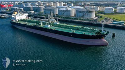
LYRIC CAMELLIA
Tanker
Current Trip
| Time Travelled | 42 days |
|---|---|
| Remaining Time | 2 h, 32 mins |
| Distance Travelled | 6033.03 nm |
| Remaining Distance | 60.00 nm |
| AVG Speed | 12.5 Noeuds |
| MAX Speed | 12.5 Noeuds |
| AVG Wind | 12.4 knots |
| MAX Wind | 31.9 knots |
| MIN Temp | 10.6°C / 51.08°F |
| MAX Temp | 31.6°C / 88.88°F |
| Tirant d eau | 14.5 m |
| Position reçue | 1 d depuis |
Current Position
| Longitude | 37.84533° |
|---|---|
| Latitude | 22.39651° |
| Etat | Under way using engine |
| Vitesse | 12.5 Noeuds |
| Parcours | 331.3° |
| Zone | Red Sea |
| Station | T-AIS |
| Position reçue | 1 d depuis |
Info
Information
The current position of LYRIC CAMELLIA is in Red Sea with coordinates 22.39651° / 37.84533° as reported on 2024-05-03 21:47 by AIS to our vessel tracker app. The vessel's current speed is 12.5 Noeuds and is heading at the port of SUEZ CANAL. The estimated time of arrival as calculated by MyShipTracking vessel tracking app is 2024-05-05 18:05 LT
The vessel LYRIC CAMELLIA (IMO: 9730933, MMSI: 311000359) is a Tanker It's sailing under the flag of [BS] Bahamas.
In this page you can find informations about the vessels current position, last detected port calls, and current voyage information. If the vessels is not in coverage by AIS you will find the latest position.
The current position of LYRIC CAMELLIA is detected by our AIS receivers and we are not responsible for the reliability of the data. The last position was recorded while the vessel was in Coverage by the Ais receivers of our vessel tracking app.
The current draught of LYRIC CAMELLIA as reported by AIS is 14.5 meters
Weather
| Temperature | 25.3°C / 77.54°F |
|---|---|
| Wind Speed | 16 knots |
| Direction | 318° NW |
| Pressure | 1008.5 hPa |
| Humidity | 39 % |
| Cloud Coverage | --- |
Featured Company
Last Port Calls
| Port | Arrival | Departure | Time In Port |
|---|---|---|---|
| 2024-04-25 11:12 | 2024-04-25 19:21 | 8 h | |
| 2024-04-12 06:17 | 2024-04-12 15:42 | 9 h | |
| 2024-03-22 14:15 | 2024-03-23 23:00 | 1 d | |
| 2024-03-04 08:44 | 2024-03-04 18:04 | 9 h |
Most Visited Ports (Last year)
| Port | Arrivals | |
|---|---|---|
| 13 | ||
| 4 | ||
| 3 | ||
| 2 | ||
| 2 | ||
| 1 |
Last Trips
| Origin | Departure | Destination | Arrival | Distance | |
|---|---|---|---|---|---|
| 2024-03-24 02:00 | 2024-04-25 13:12 | 4453.45 nm | |||
| 2024-03-24 02:00 | 2024-04-12 08:17 | 1553.58 nm | |||
| 2024-01-18 02:50 | 2024-03-22 17:15 | 6231.91 nm | |||
| 2024-01-18 02:50 | 2024-03-04 10:44 | 4911.68 nm |
Events
| Heure | Evenement | Détails | Position/ Destination | Info |
|---|---|---|---|---|
| 2024-05-03 22:05 | Etat Changé | Default Under way using engine |
22.47265 / 37.80116
SUEZ
|
Vitesse: 12.5 kn Parcours: 331.3° |
| 2024-05-03 21:47 | Hors de la zone couverte |
22.39651 / 37.84533
Red Sea
SUEZ
|
Vitesse: 12.5 kn Parcours: 331.3° |
|
| 2024-05-03 20:45 | Etat Changé | Under way using engine Default |
22.22822 / 37.94217
SUEZ
|
Vitesse: 11.9 kn Parcours: 333° |
| 2024-05-03 20:09 | Etat Changé | Default Under way using engine |
22.12268 / 38.00000
SUEZ
|
Vitesse: 11.9 kn Parcours: 334.3° |
| 2024-05-03 18:46 | Etat Changé | Under way using engine Default |
21.88642 / 38.14859
SUEZ
|
Vitesse: 12.2 kn Parcours: 330° |
| 2024-05-03 18:40 | Etat Changé | Default Under way using engine |
21.86913 / 38.15918
SUEZ
|
Vitesse: 12.3 kn Parcours: 332.5° |
| 2024-05-03 18:31 | Etat Changé | Under way using engine Default |
21.83796 / 38.17680
SUEZ
|
Vitesse: 12.3 kn Parcours: 331° |
| 2024-05-03 18:11 | Etat Changé | Default Under way using engine |
21.77803 / 38.20710
SUEZ
|
Vitesse: 12.4 kn Parcours: 334.6° |
| 2024-05-03 18:05 | Etat Changé | Under way using engine Default |
21.76063 / 38.21582
SUEZ
|
Vitesse: 12.5 kn Parcours: 334° |
| 2024-05-03 16:52 | Hors de la zone couverte |
21.52996 / 38.34786
Red Sea
SUEZ
|
Vitesse: 12.2 kn Parcours: 329.5° |