

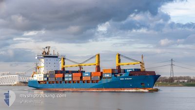
JONNI RITSCHER
Container Ship

Current Trip
| Trip Time | 2 days |
|---|---|
| Trip Distance | 958.06 nm |
| AVG Speed | 15.2 Noeuds |
| MAX Speed | 16.8 Noeuds |
| Tirant d eau | 9.6 m |
| AVG Wind | 26.1 knots |
| MAX Wind | 39.3 knots |
| MIN Temp | 3.2°C / 37.76°F |
| MAX Temp | 11.5°C / 52.7°F |
| Position reçue | 6 d depuis |
Current Position
| Longitude | --- |
|---|---|
| Latitude | --- |
| Etat | Under way using engine |
| Vitesse | 14.2 Noeuds |
| Parcours | 291.4° |
| Zone | North Atlantic Ocean |
| Station | T-AIS |
| Position reçue | 6 d depuis |
Information
The current position of JONNI RITSCHER is in North Atlantic Ocean with coordinates 59.00684° / -4.74699° as reported on 2025-02-21 18:42 by AIS to our vessel tracker app. The vessel's current speed is 14.2 Noeuds and is currently inside the port of REYKJAVIK.
The vessel JONNI RITSCHER (IMO: 9333383, MMSI: 636091136) is a Container Ship that was built in 2006 ( 19 Age ). It's sailing under the flag of [LR] Liberia.
In this page you can find informations about the vessels current position, last detected port calls, and current voyage information. If the vessels is not in coverage by AIS you will find the latest position.
The current position of JONNI RITSCHER is detected by our AIS receivers and we are not responsible for the reliability of the data. The last position was recorded while the vessel was in Coverage by the Ais receivers of our vessel tracking app.
The current draught of JONNI RITSCHER as reported by AIS is 9.6 meters
Weather
| Temperature | 0.1°C / 32.18°F |
|---|---|
| Wind Speed | 11 knots |
| Direction | 3° N |
| Pressure | 974.1 hPa |
| Humidity | 69.2 % |
| Cloud Coverage | 94 % |


Featured Company
Last Port Calls
| Port | Arrival | Departure | Time In Port |
|---|---|---|---|
| 2025-02-23 13:05 | |||
| 2025-02-20 13:08 | 2025-02-20 21:41 | 8 h | |
| 2025-02-17 09:40 | 2025-02-19 18:36 | 2 d | |
| 2025-02-17 09:27 | |||
| 2025-02-11 07:59 | |||
| 2025-02-09 12:07 | 2025-02-11 06:10 | 1 d | |
| 2025-02-06 13:02 | 2025-02-06 22:41 | 9 h | |
| 2025-02-02 23:30 | 2025-02-05 17:36 | 2 d | |
| 2025-01-31 03:41 | |||
| 2025-01-28 10:17 | 2025-01-29 16:16 | 1 d |
Most Visited Ports (Last year)
| Port | Arrivals | |
|---|---|---|
| 47 | ||
| 43 | ||
| 31 | ||
| 26 | ||
| 6 |
Last Trips
| Origin | Departure | Destination | Arrival | Distance | |
|---|---|---|---|---|---|
| 2025-02-20 21:41 | 2025-02-23 13:05 | 958.06 nm | |||
| 2025-02-19 18:36 | 2025-02-20 13:08 | 281.69 nm | |||
| 2025-02-11 06:10 | 2025-02-11 07:59 | 13.54 nm | |||
| 2025-02-06 22:41 | 2025-02-09 12:07 | 963.98 nm | |||
| 2025-02-05 17:36 | 2025-02-06 13:02 | 278.36 nm | |||
| 2025-01-31 03:41 | 2025-02-02 23:30 | 1115.66 nm | |||
| 2025-01-28 09:12 | 2025-01-28 10:17 | 11.18 nm | |||
| 2025-01-22 23:14 | 2025-01-23 14:00 | 278.24 nm | |||
| 2025-01-21 13:18 | 2025-01-21 14:23 | 3.38 nm | |||
| 2025-01-20 21:31 | 2025-01-20 22:06 | 2.14 nm |
Events
| Heure | Evenement | Détails | Position/ Destination | Info |
|---|---|---|---|---|
| 2025-02-23 13:05 | Arret |
64.14970 / -21.84369
[IS] REYKJAVIK
|
Vitesse: 0.1 kn Parcours: 134° |
|
| 2025-02-23 13:05 | Port d'arrivée |
|
64.14970 / -21.84369
[IS] REYKJAVIK
|
Vitesse: 2.4 kn Parcours: 133° |
| 2025-02-21 18:47 | Etat Changé | Default Under way using engine |
59.01415 / -4.78720
ISREY
|
Vitesse: 14.2 kn Parcours: 291.4° |
| 2025-02-21 18:42 | Hors de la zone couverte |
59.00684 / -4.74699
North Atlantic Ocean
ISREY
|
Vitesse: 14.2 kn Parcours: 291.4° |
|
| 2025-02-21 15:34 | Changement de zone | United Kingdom part of the North Atlantic Ocean United Kingdom part of the North Sea |
58.77167 / -3.43193
North Atlantic Ocean
ISREY
|
Vitesse: 14.2 kn Parcours: 286.2° |
| 2025-02-21 15:28 | Etat Changé | Under way using engine Default |
58.76583 / -3.38991
ISREY
|
Vitesse: 13.9 kn Parcours: 284° |
| 2025-02-21 15:19 | Etat Changé | Default Under way using engine |
58.75748 / -3.32749
ISREY
|
Vitesse: 12.5 kn Parcours: 286.3° |
| 2025-02-21 13:19 | Etat Changé | Under way using engine Default |
58.49455 / -2.69162
ISREY
|
Vitesse: 15.7 kn Parcours: 322° |
| 2025-02-21 13:11 | Dans la zone couverte |
58.49455 / -2.69162
North Sea
ISREY
|
Vitesse: 15.6 kn Parcours: 321.3° |
|
| 2025-02-21 10:48 | Hors de la zone couverte |
57.98575 / -1.87332
North Sea
ISREY
|
Vitesse: 16.4 kn Parcours: 319.7° |