
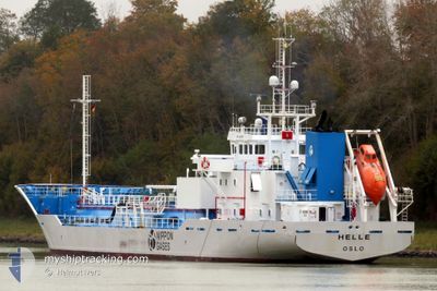
HELLE
Lpg Tanker
Current Trip
| Time Travelled | 20 h, 43 mins |
|---|---|
| Remaining Time | 1 day |
| Distance Travelled | 264.37 nm |
| Remaining Distance | 412.95 nm |
| AVG Speed | 12.1 Noeuds |
| MAX Speed | 14.5 Noeuds |
| AVG Wind | 26.7 knots |
| MAX Wind | 29.9 knots |
| MIN Temp | 1.1°C / 33.98°F |
| MAX Temp | 9.9°C / 49.82°F |
| Tirant d eau | 3.7 m |
| Position reçue | 4 h, 8 m depuis |
Current Position
| Longitude | --- |
|---|---|
| Latitude | --- |
| Etat | Under way using engine |
| Vitesse | 12.6 Noeuds |
| Parcours | 220.4° |
| Zone | Celtic Sea |
| Station | T-AIS |
| Position reçue | 4 h, 8 m depuis |
Info
Information
The current position of HELLE is in Celtic Sea with coordinates 50.72319° / -5.73680° as reported on 2024-11-22 12:28 by AIS to our vessel tracker app. The vessel's current speed is 12.6 Noeuds and is heading at the port of SLUISKIL. The estimated time of arrival as calculated by MyShipTracking vessel tracking app is 2024-11-23 23:56 LT
The vessel HELLE (IMO: 9201906, MMSI: 257510000) is a Lpg Tanker that was built in 1999 ( 25 Age ). It's sailing under the flag of [NO] Norway.
In this page you can find informations about the vessels current position, last detected port calls, and current voyage information. If the vessels is not in coverage by AIS you will find the latest position.
The current position of HELLE is detected by our AIS receivers and we are not responsible for the reliability of the data. The last position was recorded while the vessel was in Coverage by the Ais receivers of our vessel tracking app.
The current draught of HELLE as reported by AIS is 3.7 meters
Weather
| Temperature | 9.9°C / 49.82°F |
|---|---|
| Wind Speed | 10 knots |
| Direction | 297° WNW |
| Pressure | 1013.8 hPa |
| Humidity | 57 % |
| Cloud Coverage | 100 % |
Featured Company
Last Port Calls
| Port | Arrival | Departure | Time In Port |
|---|---|---|---|
| 2024-11-21 06:26 | 2024-11-21 19:54 | 13 h | |
| 2024-11-16 08:13 | 2024-11-16 19:35 | 11 h | |
| 2024-11-14 01:13 | 2024-11-14 12:30 | 11 h | |
| 2024-11-09 11:45 | 2024-11-12 08:50 | 2 d | |
| 2024-10-28 13:24 | 2024-11-08 16:14 | 11 d | |
| 2024-10-25 15:04 | 2024-10-25 20:59 | 5 h | |
| 2024-10-21 06:45 | 2024-10-23 17:15 | 2 d | |
| 2024-10-18 22:12 | 2024-10-19 05:52 | 7 h | |
| 2024-10-16 21:20 | 2024-10-17 13:58 | 16 h | |
| 2024-10-15 08:30 | 2024-10-15 21:21 | 12 h |
Last Trips
| Origin | Departure | Destination | Arrival | Distance | |
|---|---|---|---|---|---|
| 2024-11-16 20:35 | 2024-11-21 06:26 | 1188.60 nm | |||
| 2024-11-14 12:30 | 2024-11-16 09:13 | 472.29 nm | |||
| 2024-11-12 09:50 | 2024-11-14 01:13 | 468.83 nm | |||
| 2024-11-08 17:14 | 2024-11-09 12:45 | 248.56 nm | |||
| 2024-10-25 21:59 | 2024-10-28 14:24 | 601.54 nm | |||
| 2024-10-23 19:15 | 2024-10-25 16:04 | 469.78 nm | |||
| 2024-10-19 07:52 | 2024-10-21 08:45 | 410.62 nm | |||
| 2024-10-17 15:58 | 2024-10-19 00:12 | 173.76 nm | |||
| 2024-10-15 23:21 | 2024-10-16 23:20 | 247.25 nm | |||
| 2024-10-13 12:34 | 2024-10-15 10:30 | 472.47 nm |
Events
| Heure | Evenement | Détails | Position/ Destination | Info |
|---|---|---|---|---|
| 2024-11-22 12:35 | Etat Changé | Default Under way using engine |
50.70621 / -5.75873
NLSLU
|
Vitesse: 12.6 kn Parcours: 220.4° |
| 2024-11-22 12:28 | Etat Changé | Under way using engine Default |
50.72319 / -5.73680
NLSLU
|
Vitesse: 12.6 kn Parcours: 222° |
| 2024-11-22 12:28 | Hors de la zone couverte |
50.72319 / -5.73680
Celtic Sea
NLSLU
|
Vitesse: 12.6 kn Parcours: 220.4° |
|
| 2024-11-22 12:23 | Etat Changé | Default Under way using engine |
50.74001 / -5.71758
NLSLU
|
Vitesse: 12.9 kn Parcours: 174.1° |
| 2024-11-22 12:21 | Etat Changé | Under way using engine Default |
50.74517 / -5.71700
NLSLU
|
Vitesse: 13.4 kn Parcours: 165° |
| 2024-11-22 12:21 | Changement de zone | United Kingdom part of the Celtic Sea Irish part of the Irish Sea and St. George's Channel |
50.74517 / -5.71700
Celtic Sea
NLSLU
|
Vitesse: 12.9 kn Parcours: 174.1° |
| 2024-11-22 12:14 | Etat Changé | Default Under way using engine |
50.76909 / -5.72215
NLSLU
|
Vitesse: 13 kn Parcours: 166° |
| 2024-11-22 12:07 | Etat Changé | Under way using engine Default |
50.79635 / -5.72814
NLSLU
|
Vitesse: 13.3 kn Parcours: 177° |
| 2024-11-22 12:02 | Dans la zone couverte |
50.79635 / -5.72814
Irish Sea and St. George's Channel
NLSLU
|
Vitesse: 13 kn Parcours: 166° |
|
| 2024-11-22 03:16 | Hors de la zone couverte |
52.72294 / -5.67873
Irish Sea and St. George's Channel
NLSLU
|
Vitesse: 12.9 kn Parcours: 192.3° |