
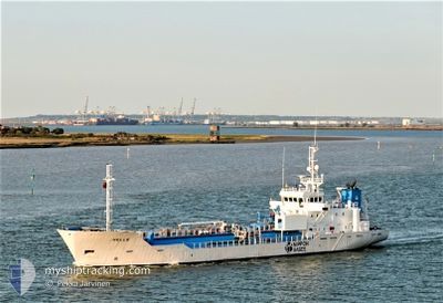
HELLE
Lpg Tanker
Current Trip
| Time Travelled | 20 h, 43 mins |
|---|---|
| Remaining Time | -2 mins |
| Distance Travelled | 140.99 nm |
| Remaining Distance | 2.42 nm |
| AVG Speed | 9.2 Knop |
| MAX Speed | 12.6 Knop |
| AVG Wind | 13.2 knots |
| MAX Wind | 21 knots |
| MIN Temp | 6.5°C / 43.7°F |
| MAX Temp | 11.3°C / 52.34°F |
| Djupgående | 4 m |
| Position mottagen | Nu |
Current Position
| Longitud | 0.33864° |
|---|---|
| Latitude | 51.45104° |
| Status | Under way using engine |
| Fart | 7.3 Knop |
| Kurs | 300.6° |
| Område | North Sea |
| Station | T-AIS |
| Position mottagen | Nu |
Info
Information
The current position of HELLE is in North Sea with coordinates 51.45104° / 0.33864° as reported on 2024-04-25 10:38 by AIS to our vessel tracker app. The vessel's current speed is 7.3 Knop and is heading at the port of TILBURY. The estimated time of arrival as calculated by MyShipTracking vessel tracking app is 2024-04-25 10:36 LT
The vessel HELLE (IMO: 9201906, MMSI: 257510000) is a Lpg Tanker that was built in 1999 ( 25 År gammal ). It's sailing under the flag of [NO] Norway.
In this page you can find informations about the vessels current position, last detected port calls, and current voyage information. If the vessels is not in coverage by AIS you will find the latest position.
The current position of HELLE is detected by our AIS receivers and we are not responsible for the reliability of the data. The last position was recorded while the vessel was in Coverage by the Ais receivers of our vessel tracking app.
The current draught of HELLE as reported by AIS is 4 meters
Weather
| Temperature | 10.9°C / 51.62°F |
|---|---|
| Wind Speed | 8 knots |
| Direction | 259° W |
| Pressure | 1004.3 hPa |
| Humidity | 52.5 % |
| Cloud Coverage | 100 % |
Featured Company
Last Port Calls
| Port | Arrival | Departure | Time In Port |
|---|---|---|---|
| 2024-04-24 12:49 | 2024-04-24 13:55 | 1 h | |
| 2024-04-23 14:15 | 2024-04-24 12:39 | 22 h | |
| 2024-04-21 19:24 | 2024-04-22 06:50 | 11 h | |
| 2024-04-20 10:15 | 2024-04-20 11:59 | 1 h | |
| 2024-04-18 20:38 | 2024-04-20 10:07 | 1 d | |
| 2024-04-17 13:56 | 2024-04-18 04:51 | 14 h | |
| 2024-04-16 21:21 | 2024-04-16 22:30 | 1 h | |
| 2024-04-16 21:09 | 2024-04-16 21:16 | 7 m | |
| 2024-04-14 23:35 | 2024-04-16 20:55 | 1 d | |
| 2024-04-12 10:20 | 2024-04-14 07:36 | 1 d |
Last Trips
| Origin | Departure | Destination | Arrival | Distance | |
|---|---|---|---|---|---|
| 2024-04-24 14:39 | 2024-04-24 14:49 | 0.97 nm | |||
| 2024-04-22 07:50 | 2024-04-23 16:15 | 290.98 nm | |||
| 2024-04-20 13:59 | 2024-04-21 20:24 | 283.29 nm | |||
| 2024-04-20 12:07 | 2024-04-20 12:15 | 0.86 nm | |||
| 2024-04-18 05:51 | 2024-04-18 22:38 | 141.13 nm | |||
| 2024-04-17 00:30 | 2024-04-17 14:56 | 137.93 nm | |||
| 2024-04-16 23:16 | 2024-04-16 23:21 | 0.75 nm | |||
| 2024-04-16 22:55 | 2024-04-16 23:09 | 0.72 nm | |||
| 2024-04-14 08:36 | 2024-04-15 01:35 | 141.54 nm | |||
| 2024-04-11 19:27 | 2024-04-12 11:20 | 141.24 nm |
Events
| Tid | Event | Detaljer | Position / Dest | Information |
|---|---|---|---|---|
| 2024-04-25 05:30 | STARTAR förflyttning | 13.01 nm, North of RAMSGATE |
51.53936 / 1.47834
GB TIL
|
Fart: 3.1 kn Kurs: 278° |
| 2024-04-25 05:27 | Status ändrad | Under way using engine At anchor |
51.53865 / 1.47869
GB TIL
|
Fart: 0.4 kn Kurs: 291° |
| 2024-04-25 04:51 | Status ändrad | At anchor Under way using engine |
51.53884 / 1.47844
GB TIL
|
Fart: 0.4 kn Kurs: 254° |
| 2024-04-24 22:36 | STOPPAR förflyttning | 12.93 nm, North of RAMSGATE |
51.53824 / 1.47510
GB TIL
|
Fart: 0.3 kn Kurs: 38° |
| 2024-04-24 20:02 | Byter havsområde | United Kingdom part of the North Sea French part of the North Sea |
51.41276 / 2.07445
North Sea
GB TIL
|
Fart: 10.5 kn Kurs: 306.4° |
| 2024-04-24 19:41 | Status ändrad | Under way using engine Default |
51.38385 / 2.16431
GB TIL
|
Fart: 10.5 kn Kurs: 298° |
| 2024-04-24 19:36 | Status ändrad | Default Under way using engine |
51.37845 / 2.18430
GB TIL
|
Fart: 11.1 kn Kurs: 295.6° |
| 2024-04-24 19:30 | Status ändrad | Under way using engine Default |
51.37095 / 2.21092
GB TIL
|
Fart: 11.2 kn Kurs: 294° |
| 2024-04-24 19:28 | Status ändrad | Default Under way using engine |
51.36831 / 2.22026
GB TIL
|
Fart: 11.6 kn Kurs: 292.7° |
| 2024-04-24 19:05 | Byter havsområde | French part of the North Sea Belgian part of the North Sea |
51.35540 / 2.33237
North Sea
GB TIL
|
Fart: 12.6 kn Kurs: 251.2° |