
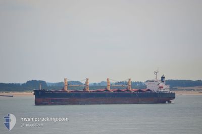
GENCO WARRIOR
Bulk Carrier
Current Trip
| Time Travelled | 12 days |
|---|---|
| Remaining Time | --- |
| Distance Travelled | 1813.36 nm |
| Remaining Distance | --- |
| AVG Speed | 11.4 Noeuds |
| MAX Speed | 14.6 Noeuds |
| AVG Wind | 10.6 knots |
| MAX Wind | 15.9 knots |
| MIN Temp | 20.5°C / 68.9°F |
| MAX Temp | 27.9°C / 82.22°F |
| Tirant d eau | 11 m |
| Position reçue | 6 d depuis |
Current Position
| Longitude | -68.67619° |
|---|---|
| Latitude | 11.65557° |
| Etat | Under way using engine |
| Vitesse | 10.7 Noeuds |
| Parcours | 122.7° |
| Zone | Caribbean Sea |
| Station | T-AIS |
| Position reçue | 6 d depuis |
Info
Information
The current position of GENCO WARRIOR is in Caribbean Sea with coordinates 11.65557° / -68.67619° as reported on 2024-04-24 14:38 by AIS to our vessel tracker app. The vessel's current speed is 10.7 Noeuds
The vessel GENCO WARRIOR (IMO: 9316153, MMSI: 538002808) is a Bulk Carrier that was built in 2005 ( 19 Age ). It's sailing under the flag of [MH] Marshall Is.
In this page you can find informations about the vessels current position, last detected port calls, and current voyage information. If the vessels is not in coverage by AIS you will find the latest position.
The current position of GENCO WARRIOR is detected by our AIS receivers and we are not responsible for the reliability of the data. The last position was recorded while the vessel was in Coverage by the Ais receivers of our vessel tracking app.
The current draught of GENCO WARRIOR as reported by AIS is 11 meters
Weather
| Temperature | 26.6°C / 79.88°F |
|---|---|
| Wind Speed | 12 knots |
| Direction | 61° ENE |
| Pressure | 1008.7 hPa |
| Humidity | 81.7 % |
| Cloud Coverage | 15 % |
Featured Company
Last Port Calls
| Port | Arrival | Departure | Time In Port |
|---|---|---|---|
| 2024-04-15 13:11 | 2024-04-18 09:07 | 2 d | |
| 2024-03-29 01:36 | 2024-04-09 06:07 | 11 d | |
| 2024-03-01 20:16 | |||
| 2024-02-13 08:14 | 2024-02-22 10:50 | 9 d | |
| 2024-02-08 21:22 | 2024-02-09 20:48 | 23 h |
Most Visited Ports (Last year)
| Port | Arrivals | |
|---|---|---|
| 9 | ||
| 2 | ||
| 2 | ||
| 1 | ||
| 1 | ||
| 1 |
Last Trips
| Origin | Departure | Destination | Arrival | Distance | |
|---|---|---|---|---|---|
| 2024-04-09 01:07 | 2024-04-15 08:11 | 467.47 nm | |||
| 2024-03-01 23:16 | 2024-03-28 20:36 | 6632.58 nm | |||
| 2024-02-09 22:48 | 2024-02-13 10:14 | 13.38 nm | |||
| 2024-01-15 13:48 | 2024-02-08 23:22 | 5215.70 nm |
Events
| Heure | Evenement | Détails | Position/ Destination | Info |
|---|---|---|---|---|
| 2024-04-24 14:46 | Etat Changé | Default Under way using engine |
11.64109 / -68.65366
PUERTO CABELLO
|
Vitesse: 10.7 kn Parcours: 122.7° |
| 2024-04-24 14:38 | Hors de la zone couverte |
11.65557 / -68.67619
Caribbean Sea
PUERTO CABELLO
|
Vitesse: 10.7 kn Parcours: 122.7° |
|
| 2024-04-24 14:34 | Etat Changé | Under way using engine Default |
11.66209 / -68.68634
PUERTO CABELLO
|
Vitesse: 10.7 kn Parcours: 124° |
| 2024-04-24 14:22 | Etat Changé | Default Under way using engine |
11.68043 / -68.71438
PUERTO CABELLO
|
Vitesse: 10.6 kn Parcours: 123.7° |
| 2024-04-24 14:10 | Etat Changé | Under way using engine Default |
11.70149 / -68.74667
PUERTO CABELLO
|
Vitesse: 10.7 kn Parcours: 124° |
| 2024-04-24 14:06 | Etat Changé | Default Under way using engine |
11.70673 / -68.75462
PUERTO CABELLO
|
Vitesse: 10.6 kn Parcours: 124.9° |
| 2024-04-24 13:56 | Detecté en mer | Venezuelan part of the Caribbean Sea |
11.72546 / -68.78232
Caribbean Sea
PUERTO CABELLO
|
Vitesse: 10.6 kn Parcours: 124° |
| 2024-04-24 12:46 | Tirant d'eau modifié | 11 11.5 |
11.84172 / -68.95481
PUERTO CABELLO
|
Vitesse: 10.6 kn Parcours: 123.7° |
| 2024-04-24 12:46 | Changement d'ETA | 2024/04/24 23:00 2024/04/25 05:00 |
11.84172 / -68.95481
PUERTO CABELLO
|
Vitesse: 10.6 kn Parcours: 123.7° |
| 2024-04-24 12:42 | Etat Changé | Under way using engine Default |
11.84712 / -68.96322
PUERTO CABELLO
|
Vitesse: 10.5 kn Parcours: 124° |