
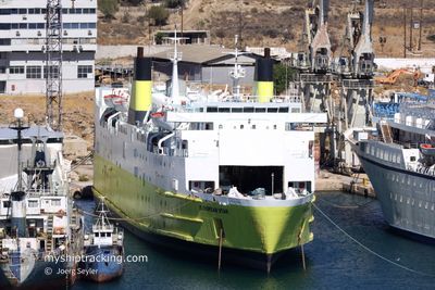
EUROPEAN STAR
Ro-Ro/Passenger Ship
Current Trip
| Time Travelled | 6 h, 52 mins |
|---|---|
| Remaining Time | --- |
| Distance Travelled | 5.33 nm |
| Remaining Distance | --- |
| AVG Speed | 6.3 Noeuds |
| MAX Speed | 8.8 Noeuds |
| AVG Wind | 8 knots |
| MAX Wind | 8.8 knots |
| MIN Temp | 22°C / 71.6°F |
| MAX Temp | 24.4°C / 75.92°F |
| Tirant d eau | 4.9 m |
| Position reçue | 1 m depuis |
Current Position
| Longitude | 23.56322° |
|---|---|
| Latitude | 37.91886° |
| Etat | At anchor |
| Vitesse | |
| Parcours | 196° |
| Zone | Aegean Sea |
| Station | T-AIS |
| Position reçue | 1 m depuis |
Info
Information
The current position of EUROPEAN STAR is in Aegean Sea with coordinates 37.91886° / 23.56322° as reported on 2024-05-21 16:43 by AIS to our vessel tracker app. The vessel's current speed is 0 Noeuds
The vessel EUROPEAN STAR (IMO: 7813949, MMSI: 374081000) is a Ro-Ro/Passenger Ship that was built in 1981 ( 43 Age ). It's sailing under the flag of [PA] Panama.
In this page you can find informations about the vessels current position, last detected port calls, and current voyage information. If the vessels is not in coverage by AIS you will find the latest position.
The current position of EUROPEAN STAR is detected by our AIS receivers and we are not responsible for the reliability of the data. The last position was recorded while the vessel was in Coverage by the Ais receivers of our vessel tracking app.
The current draught of EUROPEAN STAR as reported by AIS is 4.9 meters
Weather
| Temperature | 21.9°C / 71.42°F |
|---|---|
| Wind Speed | 3 knots |
| Direction | 151° SSE |
| Pressure | 1012.6 hPa |
| Humidity | 61.3 % |
| Cloud Coverage | 32 % |
Featured Company
Events
| Heure | Evenement | Détails | Position/ Destination | Info |
|---|---|---|---|---|
| 2024-05-21 10:53 | Etat Changé | At anchor Under way using engine |
37.91899 / 23.56242
PIREAUS ANCHORAGE
|
Vitesse: 0.5 kn Parcours: 146° |
| 2024-05-21 10:53 | Changement de destination | PIREAUS ANCHORAGE DRAPETSONA |
37.91901 / 23.56239
PIREAUS ANCHORAGE
|
Vitesse: 0.5 kn Parcours: 146° |
| 2024-05-21 10:53 | Changement d'ETA | 2024/05/21 13:53 2024/05/14 08:00 |
37.91901 / 23.56239
PIREAUS ANCHORAGE
|
Vitesse: 0.5 kn Parcours: 146° |
| 2024-05-21 10:48 | Arret | 1.91 nm, South West of PSYTTALEIA |
37.91921 / 23.56160
DRAPETSONA
|
Vitesse: 0.3 kn Parcours: 138° |
| 2024-05-21 10:36 | Démarrage | 2.09 nm, South West of PSYTTALEIA |
37.91285 / 23.56611
DRAPETSONA
|
Vitesse: 3.1 kn Parcours: 150° |
| 2024-05-21 10:31 | Arret | 2.27 nm, South West of PSYTTALEIA |
37.90966 / 23.56549
DRAPETSONA
|
Vitesse: 0.3 kn Parcours: 194° |
| 2024-05-21 09:52 | PORT DE DEPART |
|
37.94683 / 23.59746
DRAPETSONA
|
Vitesse: 5.2 kn Parcours: 138° |
| 2024-05-21 09:45 | Etat Changé | Under way using engine Moored |
37.95292 / 23.60112
[GR] PIRAEUS
|
Vitesse: 1.8 kn Parcours: 293° |
| 2024-05-21 09:44 | Démarrage |
37.95194 / 23.60204
[GR] PIRAEUS
|
Vitesse: 3.2 kn Parcours: 1° |
|
| 2024-05-21 08:28 | Changement d'ETA | 2024/05/14 08:00 2025/01/01 08:00 |
37.95007 / 23.60153
[GR] PIRAEUS
|
Vitesse: Parcours: 9° |