
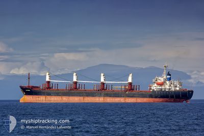
EKATERINA
Bulk Carrier
Current Trip
| Time Travelled | 25 days |
|---|---|
| Remaining Time | --- |
| Distance Travelled | 3795.86 nm |
| Remaining Distance | --- |
| AVG Speed | 9.7 Noeuds |
| MAX Speed | 13.7 Noeuds |
| AVG Wind | 10.8 knots |
| MAX Wind | 41.7 knots |
| MIN Temp | 10.8°C / 51.44°F |
| MAX Temp | 22.3°C / 72.14°F |
| Tirant d eau | 9.8 m |
| Position reçue | 1 d depuis |
Current Position
| Longitude | 10.46552° |
|---|---|
| Latitude | 36.81905° |
| Etat | At anchor |
| Vitesse | |
| Parcours | 133° |
| Zone | Mediterranean Sea - Western Basin |
| Station | T-AIS |
| Position reçue | 1 d depuis |
Info
Information
The current position of EKATERINA is in Mediterranean Sea - Western Basin with coordinates 36.81905° / 10.46552° as reported on 2024-04-27 01:36 by AIS to our vessel tracker app. The vessel's current speed is 0 Noeuds
The vessel EKATERINA (IMO: 9158458, MMSI: 215776000) is a Bulk Carrier that was built in 2000 ( 24 Age ). It's sailing under the flag of [MT] Malta.
In this page you can find informations about the vessels current position, last detected port calls, and current voyage information. If the vessels is not in coverage by AIS you will find the latest position.
The current position of EKATERINA is detected by our AIS receivers and we are not responsible for the reliability of the data. The last position was recorded while the vessel was in Coverage by the Ais receivers of our vessel tracking app.
The current draught of EKATERINA as reported by AIS is 9.8 meters
Weather
| Temperature | 14.9°C / 58.82°F |
|---|---|
| Wind Speed | 9 knots |
| Direction | 129° SE |
| Pressure | 1014 hPa |
| Humidity | 93.3 % |
| Cloud Coverage | 4 % |
Featured Company
Last Port Calls
| Port | Arrival | Departure | Time In Port |
|---|---|---|---|
| 2024-04-03 07:54 | |||
| 2024-03-09 15:14 | |||
| 2024-02-09 14:03 | 2024-02-15 23:12 | 6 d |
Events
| Heure | Evenement | Détails | Position/ Destination | Info |
|---|---|---|---|---|
| 2024-04-27 01:39 | Etat Changé | Default At anchor |
36.81905 / 10.46548
RUKZP-TNRDS
|
Vitesse: Parcours: 133° |
| 2024-04-27 01:36 | Hors de la zone couverte |
36.81905 / 10.46552
Mediterranean Sea - Western Basin
|
Vitesse: Parcours: 219.1° |
|
| 2024-04-27 00:51 | Detecté en mer | Tunisian part of the Mediterranean Sea - Western Basin |
36.81900 / 10.46549
Mediterranean Sea - Western Basin
|
Vitesse: Parcours: 219.1° |
| 2024-04-27 00:51 | Etat Changé | At anchor Default |
36.81900 / 10.46549
RUKZP-TNRDS
|
Vitesse: Parcours: 134° |
| 2024-04-27 00:31 | Dans la zone couverte |
36.81900 / 10.46549
Mediterranean Sea - Western Basin
|
Vitesse: Parcours: 219.1° |
|
| 2024-04-26 17:28 | Arret | 6.3 nm, South East of SIDI BOU SAID |
36.81667 / 10.46667
RUKZP-TNRDS
|
Vitesse: Parcours: -1° |
| 2024-04-26 07:01 | Etat Changé | Default Under way using engine |
37.05667 / 12.29167
RUKZP-TNRDS
|
Vitesse: 11.2 kn Parcours: 286.4° |
| 2024-04-26 06:53 | Hors de la zone couverte |
37.04946 / 12.32226
Mediterranean Sea - Eastern Basin
RUKZP-TNRDS
|
Vitesse: 11.2 kn Parcours: 286.4° |
|
| 2024-04-26 06:38 | Etat Changé | Under way using engine Default |
37.03504 / 12.37742
RUKZP-TNRDS
|
Vitesse: 11 kn Parcours: 290° |
| 2024-04-26 05:58 | Etat Changé | Default Under way using engine |
36.99500 / 12.52667
RUKZP-TNRDS
|
Vitesse: 11.3 kn Parcours: 287.7° |