
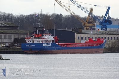
EEMS CARRIER
General Cargo
Current Trip
| Time Travelled | 4 days |
|---|---|
| Remaining Time | 14 h, 52 mins |
| Distance Travelled | 605.32 nm |
| Remaining Distance | 138.37 nm |
| AVG Speed | 7.6 Noeuds |
| MAX Speed | 9.9 Noeuds |
| AVG Wind | 6.4 knots |
| MAX Wind | 12 knots |
| MIN Temp | 4.9°C / 40.82°F |
| MAX Temp | 13.9°C / 57.02°F |
| Tirant d eau | 4.3 m |
| Position reçue | Maintenant |
Current Position
| Longitude | 19.04140° |
|---|---|
| Latitude | 60.33695° |
| Etat | Under way using engine |
| Vitesse | 9.4 Noeuds |
| Parcours | 356.5° |
| Zone | Gulf of Bothnia |
| Station | T-AIS |
| Position reçue | Maintenant |
Info
Information
The current position of EEMS CARRIER is in Gulf of Bothnia with coordinates 60.33695° / 19.04140° as reported on 2024-05-12 13:09 by AIS to our vessel tracker app. The vessel's current speed is 9.4 Noeuds and is heading at the port of SUNDSVALL. The estimated time of arrival as calculated by MyShipTracking vessel tracking app is 2024-05-13 04:02 LT
The vessel EEMS CARRIER (IMO: 9148142, MMSI: 245257000) is a General Cargo that was built in 1996 ( 28 Age ). It's sailing under the flag of [NL] Netherlands.
In this page you can find informations about the vessels current position, last detected port calls, and current voyage information. If the vessels is not in coverage by AIS you will find the latest position.
The current position of EEMS CARRIER is detected by our AIS receivers and we are not responsible for the reliability of the data. The last position was recorded while the vessel was in Coverage by the Ais receivers of our vessel tracking app.
The current draught of EEMS CARRIER as reported by AIS is 4.3 meters
Weather
| Temperature | 5.7°C / 42.26°F |
|---|---|
| Wind Speed | 8 knots |
| Direction | 172° S |
| Pressure | 1023.4 hPa |
| Humidity | 81.2 % |
| Cloud Coverage | 100 % |
Featured Company
Last Port Calls
| Port | Arrival | Departure | Time In Port |
|---|---|---|---|
| 2024-05-07 08:05 | 2024-05-07 16:22 | 8 h | |
| 2024-05-04 15:00 | 2024-05-06 14:03 | 1 d | |
| 2024-05-01 16:30 | 2024-05-02 13:15 | 20 h | |
| 2024-04-30 03:33 | 2024-05-01 07:30 | 1 d | |
| 2024-04-27 13:28 | 2024-04-28 01:32 | 12 h | |
| 2024-04-25 06:55 | 2024-04-25 14:38 | 7 h | |
| 2024-04-21 06:38 | 2024-04-22 12:57 | 1 d | |
| 2024-04-19 07:44 | 2024-04-19 12:02 | 4 h | |
| 2024-04-17 06:13 | 2024-04-17 11:35 | 5 h | |
| 2024-04-14 05:47 | 2024-04-15 09:22 | 1 d |
Last Trips
| Origin | Departure | Destination | Arrival | Distance | |
|---|---|---|---|---|---|
| 2024-05-06 16:03 | 2024-05-07 10:05 | 166.96 nm | |||
| 2024-05-02 15:15 | 2024-05-04 17:00 | 339.02 nm | |||
| 2024-05-01 09:30 | 2024-05-01 18:30 | 53.15 nm | |||
| 2024-04-28 03:32 | 2024-04-30 05:33 | 457.71 nm | |||
| 2024-04-25 16:38 | 2024-04-27 15:28 | 428.96 nm | |||
| 2024-04-22 14:57 | 2024-04-25 08:55 | 327.17 nm | |||
| 2024-04-19 14:02 | 2024-04-21 08:38 | 336.30 nm | |||
| 2024-04-17 13:35 | 2024-04-19 09:44 | 311.64 nm | |||
| 2024-04-15 11:22 | 2024-04-17 08:13 | 324.26 nm | |||
| 2024-04-12 11:32 | 2024-04-14 07:47 | 331.59 nm |
Events
| Heure | Evenement | Détails | Position/ Destination | Info |
|---|---|---|---|---|
| 2024-05-12 12:23 | Changement de zone | Swedish part of the Gulf of Bothnia Finnish part of the Gulf of Bothnia |
60.22053 / 19.09438
Gulf of Bothnia
SE SDL
|
Vitesse: 9.2 kn Parcours: 345.5° |
| 2024-05-12 11:20 | Changement de zone | Finnish part of the Gulf of Bothnia Swedish part of the Gulf of Bothnia |
60.08074 / 19.24374
Gulf of Bothnia
SE SDL
|
Vitesse: 9.1 kn Parcours: 327.6° |
| 2024-05-12 09:23 | Changement de zone | Swedish part of the Gulf of Bothnia Swedish part of the Baltic Sea |
59.82485 / 19.53834
Gulf of Bothnia
SE SDL
|
Vitesse: 9 kn Parcours: 330.8° |
| 2024-05-12 06:46 | Etat Changé | Under way using engine Default |
59.45674 / 19.70175
SE SDL
|
Vitesse: 9.2 kn Parcours: 24° |
| 2024-05-12 06:21 | Etat Changé | Default Under way using engine |
59.39777 / 19.64889
SE SDL
|
Vitesse: 9 kn Parcours: 27.4° |
| 2024-05-12 06:00 | Etat Changé | Under way using engine Default |
59.35153 / 19.60075
SE SDL
|
Vitesse: 9.1 kn Parcours: 28° |
| 2024-05-12 05:56 | Etat Changé | Default Under way using engine |
59.34409 / 19.59286
SE SDL
|
Vitesse: 9.1 kn Parcours: 27.5° |
| 2024-05-12 05:50 | Etat Changé | Under way using engine Default |
59.33059 / 19.57862
SE SDL
|
Vitesse: 9.2 kn Parcours: 28° |
| 2024-05-12 05:49 | Etat Changé | Default Under way using engine |
59.32651 / 19.57437
SE SDL
|
Vitesse: 9 kn Parcours: 27.5° |
| 2024-05-12 05:32 | Etat Changé | Under way using engine Default |
59.29090 / 19.53565
SE SDL
|
Vitesse: 8.9 kn Parcours: 29° |