
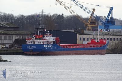
EEMS CARRIER
General Cargo
Current Trip
| Time Travelled | 2 days |
|---|---|
| Remaining Time | 28 mins |
| Distance Travelled | 323.26 nm |
| Remaining Distance | 4.67 nm |
| AVG Speed | 7.1 Knots |
| MAX Speed | 10.3 Knots |
| AVG Wind | 9.8 knots |
| MAX Wind | 19 knots |
| MIN Temp | 0.3°C / 32.54°F |
| MAX Temp | 7.6°C / 45.68°F |
| Draught | 4.3 m |
| Position Received | 1 m ago |
Current Position
| Longitude | 9.76700° |
|---|---|
| Latitude | 54.35084° |
| Status | Under way using engine |
| Speed | 7.2 Knots |
| Course | 230.5° |
| Area | Baltic Sea |
| Station | T-AIS |
| Position Received | 1 m ago |
Info
Information
The current position of EEMS CARRIER is in Baltic Sea with coordinates 54.35084° / 9.76700° as reported on 2024-04-25 06:26 by AIS to our vessel tracker app. The vessel's current speed is 7.2 Knots and is heading at the port of RENDSBURG. The estimated time of arrival as calculated by MyShipTracking vessel tracking app is 2024-04-25 06:55 LT
The vessel EEMS CARRIER (IMO: 9148142, MMSI: 245257000) is a General Cargo that was built in 1996 ( 28 years old ). It's sailing under the flag of [NL] Netherlands.
In this page you can find informations about the vessels current position, last detected port calls, and current voyage information. If the vessels is not in coverage by AIS you will find the latest position.
The current position of EEMS CARRIER is detected by our AIS receivers and we are not responsible for the reliability of the data. The last position was recorded while the vessel was in Coverage by the Ais receivers of our vessel tracking app.
The current draught of EEMS CARRIER as reported by AIS is 4.3 meters
Weather
| Temperature | 3.5°C / 38.3°F |
|---|---|
| Wind Speed | 3 knots |
| Direction | 142° SE |
| Pressure | 1003.2 hPa |
| Humidity | 90.8 % |
| Cloud Coverage | 89 % |
Featured Company
Last Port Calls
| Port | Arrival | Departure | Time In Port |
|---|---|---|---|
| 2024-04-21 06:38 | 2024-04-22 12:57 | 1 d | |
| 2024-04-19 07:44 | 2024-04-19 12:02 | 4 h | |
| 2024-04-17 06:13 | 2024-04-17 11:35 | 5 h | |
| 2024-04-14 05:47 | 2024-04-15 09:22 | 1 d | |
| 2024-04-12 05:23 | 2024-04-12 09:32 | 4 h | |
| 2024-04-07 04:17 | 2024-04-07 13:33 | 9 h | |
| 2024-04-05 06:12 | 2024-04-05 10:41 | 4 h | |
| 2024-03-30 13:25 | 2024-03-31 00:37 | 11 h | |
| 2024-03-28 08:09 | 2024-03-28 19:41 | 11 h | |
| 2024-03-25 13:16 | 2024-03-25 17:35 | 4 h |
Last Trips
| Origin | Departure | Destination | Arrival | Distance | |
|---|---|---|---|---|---|
| 2024-04-19 14:02 | 2024-04-21 08:38 | 336.30 nm | |||
| 2024-04-17 13:35 | 2024-04-19 09:44 | 311.64 nm | |||
| 2024-04-15 11:22 | 2024-04-17 08:13 | 324.26 nm | |||
| 2024-04-12 11:32 | 2024-04-14 07:47 | 331.59 nm | |||
| 2024-04-07 15:33 | 2024-04-12 07:23 | 477.02 nm | |||
| 2024-04-05 12:41 | 2024-04-07 06:17 | 440.03 nm | |||
| 2024-03-31 01:37 | 2024-04-05 08:12 | 476.77 nm | |||
| 2024-03-28 20:41 | 2024-03-30 14:25 | 426.34 nm | |||
| 2024-03-25 18:35 | 2024-03-28 09:09 | 321.28 nm | |||
| 2024-03-22 13:08 | 2024-03-25 14:16 | 311.18 nm |
Events
| Time | Event | Details | Position / Dest | Info |
|---|---|---|---|---|
| 2024-04-25 05:19 | START Moving | 7.01 nm, West of KIEL |
54.34240 / 9.96069
RENDSBURG VIA NOK
|
Speed: 3.1 kn Course: 261° |
| 2024-04-25 04:56 | STOP Moving | 6.89 nm, West of KIEL |
54.34274 / 9.96437
RENDSBURG VIA NOK
|
Speed: 0.3 kn Course: 262° |
| 2024-04-25 03:49 | START Moving | 1.37 nm, South West of STICKENHΟRN SPORT |
54.36630 / 10.14097
RENDSBURG VIA NOK
|
Speed: 3.7 kn Course: 283° |
| 2024-04-25 03:15 | STOP Moving | 1.33 nm, South West of STICKENHΟRN SPORT |
54.36573 / 10.14407
RENDSBURG VIA NOK
|
Speed: 0.3 kn Course: 281° |
| 2024-04-25 00:53 | Change Sea Area | German part of the Baltic Sea Danish part of the Baltic Sea |
54.56715 / 10.56059
Baltic Sea
RENDSBURG VIA NOK
|
Speed: 9.1 kn Course: 247.8° |
| 2024-04-24 23:56 | Detected in Sea | Danish part of the Baltic Sea |
54.58837 / 10.80401
Baltic Sea
RENDSBURG VIA NOK
|
Speed: 9 kn Course: 262.4° |
| 2024-04-24 22:02 | Detected in Sea | German part of the Baltic Sea |
54.56855 / 11.31912
Baltic Sea
RENDSBURG VIA NOK
|
Speed: 9.7 kn Course: 293.1° |
| 2024-04-24 21:37 | ETA Changed | 2024/04/25 03:00 2024/04/25 03:30 |
54.54184 / 11.42874
RENDSBURG VIA NOK
|
Speed: 10.2 kn Course: 292.1° |
| 2024-04-24 20:10 | Destination Changed | RENDSBURG VIA NOK NOK HOLTENAU |
54.45098 / 11.80152
RENDSBURG VIA NOK
|
Speed: 9.6 kn Course: 275.1° |
| 2024-04-24 12:47 | Draught Changed | 4.3 2.6 |
55.19519 / 12.18432
NOK HOLTENAU
|
Speed: 7.2 kn Course: 130.5° |