
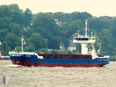
COE MINA
General Cargo
Current Trip
| Trip Time | 2 days |
|---|---|
| Trip Distance | 134.63 nm |
| AVG Speed | 9.7 Noeuds |
| MAX Speed | 12.1 Noeuds |
| Tirant d eau | 3.6 m |
| AVG Wind | 16.2 knots |
| MAX Wind | 23.8 knots |
| MIN Temp | -0.3°C / 31.46°F |
| MAX Temp | 5°C / 41°F |
| Position reçue | 3 m depuis |
Current Position
| Longitude | --- |
|---|---|
| Latitude | --- |
| Etat | Moored |
| Vitesse | |
| Parcours | 161° |
| Zone | Baltic Sea |
| Station | T-AIS |
| Position reçue | 3 m depuis |
Info
Information
The current position of COE MINA is in Baltic Sea with coordinates 54.15434° / 12.12098° as reported on 2024-11-24 21:57 by AIS to our vessel tracker app. The vessel's current speed is 0 Noeuds and is currently inside the port of ROSTOCK.
The vessel COE MINA (IMO: 8509820, MMSI: 268246900) is a General Cargo that was built in 1985 ( 39 Age ). It's sailing under the flag of [SM] San Marino.
In this page you can find informations about the vessels current position, last detected port calls, and current voyage information. If the vessels is not in coverage by AIS you will find the latest position.
The current position of COE MINA is detected by our AIS receivers and we are not responsible for the reliability of the data. The last position was recorded while the vessel was in Coverage by the Ais receivers of our vessel tracking app.
The current draught of COE MINA as reported by AIS is 3.6 meters
Weather
| Temperature | 12.5°C / 54.5°F |
|---|---|
| Wind Speed | 22 knots |
| Direction | 200° SSW |
| Pressure | 1006.5 hPa |
| Humidity | 75 % |
| Cloud Coverage | 100 % |
Featured Company
Last Port Calls
| Port | Arrival | Departure | Time In Port |
|---|---|---|---|
| 2024-11-23 02:13 | |||
| 2024-11-19 23:07 | 2024-11-20 16:51 | 17 h | |
| 2024-11-18 01:59 | 2024-11-19 11:54 | 1 d | |
| 2024-11-14 10:38 | 2024-11-16 14:10 | 2 d | |
| 2024-11-07 17:44 | 2024-11-08 11:21 | 17 h | |
| 2024-10-31 15:25 | 2024-11-04 13:43 | 3 d | |
| 2024-10-25 21:21 | 2024-10-27 12:26 | 1 d | |
| 2024-10-24 22:40 | 2024-10-25 14:35 | 15 h | |
| 2024-10-22 22:24 | 2024-10-24 12:27 | 1 d | |
| 2024-10-21 14:29 | 2024-10-22 18:06 | 1 d |
Last Trips
| Origin | Departure | Destination | Arrival | Distance | |
|---|---|---|---|---|---|
| 2024-11-20 17:51 | 2024-11-23 03:13 | 134.63 nm | |||
| 2024-11-19 12:54 | 2024-11-20 00:07 | 110.35 nm | |||
| 2024-11-16 15:10 | 2024-11-18 02:59 | 201.99 nm | |||
| 2024-11-08 12:21 | 2024-11-14 11:38 | 203.32 nm | |||
| 2024-11-04 14:43 | 2024-11-07 18:44 | 516.01 nm | |||
| 2024-10-27 13:26 | 2024-10-31 16:25 | 315.00 nm | |||
| 2024-10-25 16:35 | 2024-10-25 23:21 | 69.88 nm | |||
| 2024-10-24 14:27 | 2024-10-25 00:40 | 98.95 nm | |||
| 2024-10-22 20:06 | 2024-10-23 00:24 | 38.96 nm | |||
| 2024-10-19 17:01 | 2024-10-21 16:29 | 364.53 nm |
Events
| Heure | Evenement | Détails | Position/ Destination | Info |
|---|---|---|---|---|
| 2024-11-23 03:00 | Etat Changé | Moored Under way using engine |
54.15434 / 12.12099
[DE] ROSTOCK
|
Vitesse: Parcours: 161° |
| 2024-11-23 02:45 | Arret |
54.15427 / 12.12112
[DE] ROSTOCK
|
Vitesse: 0.3 kn Parcours: 162° |
|
| 2024-11-23 02:13 | Port d'arrivée |
|
54.18827 / 12.08905
[DE] ROSTOCK
|
Vitesse: 8.4 kn Parcours: 166° |
| 2024-11-23 00:49 | Changement de zone | German part of the Baltic Sea Danish part of the Baltic Sea |
54.36111 / 11.80210
Baltic Sea
DERSK
|
Vitesse: 10.3 kn Parcours: 123.9° |
| 2024-11-22 23:25 | Detecté en mer | Danish part of the Baltic Sea |
54.49753 / 11.44913
Baltic Sea
DERSK
|
Vitesse: 10.7 kn Parcours: 116.7° |
| 2024-11-22 21:49 | Changement de zone | German part of the Baltic Sea Danish part of the Baltic Sea |
54.63758 / 11.01985
Baltic Sea
DERSK
|
Vitesse: 11 kn Parcours: 124.5° |
| 2024-11-22 21:21 | Changement d'ETA | 2024/11/23 02:30 2024/11/23 05:00 |
54.68472 / 10.89660
DERSK
|
Vitesse: 10.9 kn Parcours: 122.8° |
| 2024-11-22 21:01 | Changement de zone | Danish part of the Baltic Sea Danish part of the Kattegat |
54.73837 / 10.86429
Baltic Sea
DERSK
|
Vitesse: 11.3 kn Parcours: 178.2° |
| 2024-11-22 14:42 | Démarrage | 7.01 nm, North of KLINTEBJERG |
55.59039 / 10.50758
DERSK
|
Vitesse: 5.5 kn Parcours: 32.7° |
| 2024-11-22 14:30 | Changement d'ETA | 2024/11/23 05:00 2024/11/20 19:00 |
55.58887 / 10.50693
DERSK
|
Vitesse: 0.5 kn Parcours: 13° |