
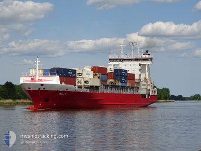
RUTH
Container Ship
Current Trip
| Time Travelled | 18 h, 58 mins |
|---|---|
| Remaining Time | 12 h, 31 mins |
| Distance Travelled | 191.99 nm |
| Remaining Distance | 77.52 nm |
| AVG Speed | 10.5 Knots |
| MAX Speed | 16.2 Knots |
| AVG Wind | 7 knots |
| MAX Wind | 13.6 knots |
| MIN Temp | -3.9°C / 24.98°F |
| MAX Temp | -0.5°C / 31.1°F |
| Dybgang | 8.8 m |
| Position Modtaget | Nu |
Current Position
| Longitude | --- |
|---|---|
| Latitude | --- |
| Status | Under way using engine |
| Fart | 7.1 Knots |
| Kurs | 275.4° |
| Område | Baltic Sea |
| Station | T-AIS |
| Position Modtaget | Nu |
Info
Information
The current position of RUTH is in Baltic Sea with coordinates 54.36383° / 9.84851° as reported on 2025-02-17 17:12 by AIS to our vessel tracker app. The vessel's current speed is 7.1 Knots and is heading at the port of HAMBURG. The estimated time of arrival as calculated by MyShipTracking vessel tracking app is 2025-02-18 05:44 LT
The vessel RUTH (IMO: 9376036, MMSI: 212613000) is a Container Ship that was built in 2008 ( 17 år gamle ). It's sailing under the flag of [CY] Cyprus.
In this page you can find informations about the vessels current position, last detected port calls, and current voyage information. If the vessels is not in coverage by AIS you will find the latest position.
The current position of RUTH is detected by our AIS receivers and we are not responsible for the reliability of the data. The last position was recorded while the vessel was in Coverage by the Ais receivers of our vessel tracking app.
The current draught of RUTH as reported by AIS is 8.8 meters
Weather
| Temperature | -3.5°C / 25.7°F |
|---|---|
| Wind Speed | 4 knots |
| Direction | 43° NE |
| Pressure | 1027 hPa |
| Humidity | 43.5 % |
| Cloud Coverage | 3 % |
Featured Company
Last Port Calls
| Port | Arrival | Departure | Time In Port |
|---|---|---|---|
| 2025-02-16 02:24 | 2025-02-16 22:15 | 19 h | |
| 2025-02-15 11:09 | 2025-02-15 23:46 | 12 h | |
| 2025-02-13 18:39 | 2025-02-14 03:30 | 8 h | |
| 2025-02-12 00:26 | 2025-02-13 09:34 | 1 d | |
| 2025-02-11 19:45 | 2025-02-11 21:57 | 2 h | |
| 2025-02-10 04:43 | 2025-02-10 20:16 | 15 h | |
| 2025-02-08 04:00 | 2025-02-08 16:14 | 12 h | |
| 2025-02-07 11:23 | 2025-02-07 11:29 | 5 m | |
| 2025-02-06 09:01 | 2025-02-06 19:00 | 9 h | |
| 2025-02-04 16:44 | 2025-02-06 00:59 | 1 d |
Most Visited Ports (Last year)
| Port | Arrivals | |
|---|---|---|
| 51 | ||
| 40 | ||
| 32 | ||
| 31 | ||
| 15 | ||
| 15 |
Last Trips
| Origin | Departure | Destination | Arrival | Distance | |
|---|---|---|---|---|---|
| 2025-02-16 00:46 | 2025-02-16 03:24 | 19.69 nm | |||
| 2025-02-14 04:30 | 2025-02-15 12:09 | 325.48 nm | |||
| 2025-02-13 10:34 | 2025-02-13 19:39 | 108.78 nm | |||
| 2025-02-11 22:57 | 2025-02-12 01:26 | 36.55 nm | |||
| 2025-02-10 21:16 | 2025-02-11 20:45 | 235.35 nm | |||
| 2025-02-08 17:14 | 2025-02-10 05:43 | 21.64 nm | |||
| 2025-02-07 12:29 | 2025-02-08 05:00 | 168.36 nm | |||
| 2025-02-06 20:00 | 2025-02-07 12:23 | 125.95 nm | |||
| 2025-02-06 01:59 | 2025-02-06 10:01 | 110.07 nm | |||
| 2025-02-04 15:05 | 2025-02-04 17:44 | 36.79 nm |
Events
| Tid | Hændelsen | Detaljer | Position / Dest | Info |
|---|---|---|---|---|
| 2025-02-17 15:26 | START Sejllads | 1.46 nm, South West of STICKENHΟRN SPORT |
54.36689 / 10.13666
DEHAM
|
Fart: 3.1 kn Kurs: 284° |
| 2025-02-17 15:01 | STOP Sejllads | 1.36 nm, South West of STICKENHΟRN SPORT |
54.36610 / 10.14168
DEHAM
|
Fart: 0.3 kn Kurs: 283° |
| 2025-02-17 13:16 | Ændre havområde | German part of the Baltic Sea Danish part of the Baltic Sea |
54.56500 / 10.55156
Baltic Sea
DEHAM
|
Fart: 15.4 kn Kurs: 246.6° |
| 2025-02-17 12:19 | Ændre havområde | Danish part of the Baltic Sea Danish part of the Kattegat |
54.73124 / 10.84184
Baltic Sea
DEHAM
|
Fart: 15.6 kn Kurs: 194.7° |
| 2025-02-16 23:44 | Ændre havområde | Danish part of the Kattegat Swedish part of the Kattegat |
56.19142 / 12.40391
Kattegat
DEHAM
|
Fart: 10 kn Kurs: 280.7° |
| 2025-02-16 22:39 | Status er ændret | Under way using engine Moored |
56.07101 / 12.62930
DEHAM
|
Fart: 9.7 kn Kurs: 317.3° |
| 2025-02-16 22:15 | Afsejlet fra sidste havn |
|
56.02489 / 12.68767
DEHAM
|
Fart: 5.6 kn Kurs: 310° |
| 2025-02-16 22:07 | START Sejllads |
56.02668 / 12.69197
[SE] HELSINGBORG
|
Fart: 3.1 kn Kurs: 339° |
|
| 2025-02-16 21:40 | Destination er ændret | DEHAM SEHEL |
56.03125 / 12.69172
[SE] HELSINGBORG
|
Fart: Kurs: 357° |
| 2025-02-16 21:37 | ETA er ændret | 2025/02/18 06:00 2025/02/16 02:00 |
56.03125 / 12.69172
[SE] HELSINGBORG
|
Fart: Kurs: 357° |