
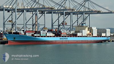
LARS MAERSK
Container Ship
Current Trip
| Time Travelled | 1 day |
|---|---|
| Remaining Time | --- |
| Distance Travelled | 563.22 nm |
| Remaining Distance | 322.86 nm |
| AVG Speed | 16.2 Knots |
| MAX Speed | 18 Knots |
| AVG Wind | 5.5 knots |
| MAX Wind | 15 knots |
| MIN Temp | 26.4°C / 79.52°F |
| MAX Temp | 28.2°C / 82.76°F |
| Dybgang | 10.1 m |
| Position Modtaget | 5 d siden |
Current Position
| Longitude | --- |
|---|---|
| Latitude | --- |
| Status | Under way using engine |
| Fart | 21.4 Knots |
| Kurs | 183.6° |
| Område | North Pacific Ocean |
| Station | T-AIS |
| Position Modtaget | 5 d siden |
Info
Information
The current position of LARS MAERSK is in North Pacific Ocean with coordinates 5.59645° / -79.60752° as reported on 2025-03-06 23:15 by AIS to our vessel tracker app. The vessel's current speed is 21.4 Knots and is heading at the port of PUERTO BOLIVAR. The estimated time of arrival as calculated by MyShipTracking vessel tracking app is 2025-03-08 06:00 LT
The vessel LARS MAERSK (IMO: 9294379, MMSI: 220291000) is a Container Ship that was built in 2004 ( 21 år gamle ). It's sailing under the flag of [DK] Denmark.
In this page you can find informations about the vessels current position, last detected port calls, and current voyage information. If the vessels is not in coverage by AIS you will find the latest position.
The current position of LARS MAERSK is detected by our AIS receivers and we are not responsible for the reliability of the data. The last position was recorded while the vessel was in Coverage by the Ais receivers of our vessel tracking app.
The current draught of LARS MAERSK as reported by AIS is 10.1 meters
Weather
| Temperature | 26.6°C / 79.88°F |
|---|---|
| Wind Speed | 9 knots |
| Direction | 36° NE |
| Pressure | 1009.4 hPa |
| Humidity | 81.4 % |
| Cloud Coverage | 100 % |
Featured Company
Last Port Calls
| Port | Arrival | Departure | Time In Port |
|---|---|---|---|
| 2025-03-09 07:26 | 2025-03-10 11:26 | 1 d | |
| 2025-03-08 04:56 | 2025-03-08 19:11 | 14 h | |
| 2025-03-04 17:00 | 2025-03-06 13:59 | 1 d | |
| 2025-03-02 21:52 | 2025-03-03 21:16 | 23 h | |
| 2025-02-27 22:42 | 2025-02-28 22:25 | 23 h | |
| 2025-02-21 09:59 | 2025-02-22 05:16 | 19 h | |
| 2025-02-10 11:41 | 2025-02-11 09:52 | 22 h | |
| 2025-02-03 20:38 | 2025-02-04 15:50 | 19 h | |
| 2025-02-01 21:03 | 2025-02-03 04:34 | 1 d | |
| 2025-01-30 12:58 | 2025-01-30 23:07 | 10 h |
Most Visited Ports (Last year)
| Port | Arrivals | |
|---|---|---|
| 11 | ||
| 10 | ||
| 10 | ||
| 8 | ||
| 6 | ||
| 6 |
Last Trips
| Origin | Departure | Destination | Arrival | Distance | |
|---|---|---|---|---|---|
| 2025-03-08 14:11 | 2025-03-09 02:26 | 88.93 nm | |||
| 2025-03-06 08:59 | 2025-03-07 23:56 | 782.96 nm | |||
| 2025-03-03 16:16 | 2025-03-04 12:00 | 362.20 nm | |||
| 2025-02-28 17:25 | 2025-03-02 16:52 | 426.59 nm | |||
| 2025-02-22 00:16 | 2025-02-27 17:42 | 1977.41 nm | |||
| 2025-02-11 10:52 | 2025-02-21 04:59 | 3889.43 nm | |||
| 2025-02-04 18:50 | 2025-02-10 12:41 | 1904.14 nm | |||
| 2025-02-03 07:34 | 2025-02-03 23:38 | 66.57 nm | |||
| 2025-01-31 02:07 | 2025-02-02 00:03 | 91.18 nm | |||
| 2025-01-29 07:47 | 2025-01-30 15:58 | 367.70 nm |
Events
| Tid | Hændelsen | Detaljer | Position / Dest | Info |
|---|---|---|---|---|
| 2025-03-10 11:35 | START Sejllads | 0.29 nm, North East of POSORJA |
-2.70408 / -80.23780
PA BLB - EC PBO
|
Fart: 7.5 kn Kurs: 161° |
| 2025-03-10 11:26 | Afsejlet fra sidste havn |
|
-2.69434 / -80.24154
PA BLB - EC PBO
|
Fart: 0.2 kn Kurs: 357° |
| 2025-03-09 07:26 | STOP Sejllads |
-2.69302 / -80.24667
[EC] POSORJA
|
Fart: 0.1 kn Kurs: 355° |
|
| 2025-03-09 07:26 | Skibe i havn |
|
-2.69302 / -80.24667
[EC] POSORJA
|
Fart: 0.4 kn Kurs: 355° |
| 2025-03-09 06:46 | START Sejllads | 0.83 nm, North East of POSORJA |
-2.69865 / -80.23000
PA BLB - EC PBO
|
Fart: 3.1 kn Kurs: 237° |
| 2025-03-09 06:08 | STOP Sejllads | 1.24 nm, North East of POSORJA |
-2.69198 / -80.22730
PA BLB - EC PBO
|
Fart: 0.3 kn Kurs: 175° |
| 2025-03-08 19:11 | Afsejlet fra sidste havn |
|
-3.23979 / -80.00790
PA BLB - EC PBO
|
Fart: 3 kn Kurs: 335° |
| 2025-03-08 05:09 | STOP Sejllads |
-3.25740 / -80.00224
[EC] PUERTO BOLIVAR
|
Fart: 0.3 kn Kurs: 359° |
|
| 2025-03-08 04:56 | Skibe i havn |
|
-3.25748 / -80.00328
[EC] PUERTO BOLIVAR
|
Fart: 0.7 kn Kurs: 80° |
| 2025-03-06 23:15 | Udenfor Dækning |
5.59645 / -79.60752
North Pacific Ocean
PA BLB - EC PBO
|
Fart: 21.4 kn Kurs: 183.6° |