
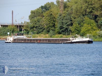
ISLAND
Wing in ground
Current Trip
| Time Travelled | 2 days |
|---|---|
| Remaining Time | --- |
| Distance Travelled | 66.59 nm |
| Remaining Distance | --- |
| AVG Speed | 6.5 Knots |
| MAX Speed | 7.3 Knots |
| AVG Wind | 5.9 knots |
| MAX Wind | 11 knots |
| MIN Temp | 6.6°C / 43.88°F |
| MAX Temp | 18.8°C / 65.84°F |
| Dybgang | 1 m |
| Position Modtaget | 1 d siden |
Current Position
| Longitude | --- |
|---|---|
| Latitude | --- |
| Status | Under way using engine |
| Fart | 5.2 Knots |
| Kurs | 118.1° |
| Område | North Sea |
| Station | T-AIS |
| Position Modtaget | 1 d siden |
Information
The current position of ISLAND is in North Sea with coordinates 52.40744° / 9.74043° as reported on 2025-03-21 14:35 by AIS to our vessel tracker app. The vessel's current speed is 5.2 Knots and is heading at the port of VERDAL.
The vessel ISLAND (MMSI: 261184980) is a Wing in ground It's sailing under the flag of [PL] Poland.
In this page you can find informations about the vessels current position, last detected port calls, and current voyage information. If the vessels is not in coverage by AIS you will find the latest position.
The current position of ISLAND is detected by our AIS receivers and we are not responsible for the reliability of the data. The last position was recorded while the vessel was in Coverage by the Ais receivers of our vessel tracking app.
The current draught of ISLAND as reported by AIS is 1 meters
Weather
| Temperature | 18.7°C / 65.66°F |
|---|---|
| Wind Speed | 11 knots |
| Direction | 113° ESE |
| Pressure | 1016.8 hPa |
| Humidity | 39.5 % |
| Cloud Coverage | 8 % |
Featured Company
Last Port Calls
| Port | Arrival | Departure | Time In Port |
|---|---|---|---|
| 2025-03-20 13:52 | 2025-03-20 13:59 | 6 m | |
| 2025-03-18 10:18 | 2025-03-20 07:00 | 1 d | |
| 2025-03-17 00:57 | 2025-03-17 05:45 | 4 h | |
| 2025-03-16 16:51 | 2025-03-17 00:54 | 8 h | |
| 2025-03-05 18:21 | 2025-03-06 06:07 | 11 h | |
| 2025-03-02 10:55 | 2025-03-02 12:46 | 1 h | |
| 2025-02-27 11:48 | 2025-03-02 09:03 | 2 d | |
| 2025-02-25 10:46 | 2025-02-27 08:24 | 1 d | |
| 2025-02-12 11:52 | 2025-02-14 13:11 | 2 d | |
| 2025-02-02 16:48 | 2025-02-03 06:16 | 13 h |
Last Trips
| Origin | Departure | Destination | Arrival | Distance | |
|---|---|---|---|---|---|
| 2025-03-20 08:00 | 2025-03-20 14:52 | 33.57 nm | |||
| 2025-03-17 06:45 | 2025-03-18 11:18 | 67.04 nm | |||
| 2025-03-17 01:54 | 2025-03-17 01:57 | 0.08 nm | |||
| 2025-03-06 07:07 | 2025-03-16 17:51 | 385.91 nm | |||
| 2025-03-02 13:46 | 2025-03-05 19:21 | 108.95 nm | |||
| 2025-03-02 10:03 | 2025-03-02 11:55 | 19.09 nm | |||
| 2025-02-27 09:24 | 2025-02-27 12:48 | 18.74 nm | |||
| 2025-02-14 14:11 | 2025-02-25 11:46 | 416.55 nm | |||
| 2025-02-03 07:16 | 2025-02-12 12:52 | 307.76 nm | |||
| 2025-01-18 09:28 | 2025-02-02 17:48 | 492.81 nm |
Events
| Tid | Hændelsen | Detaljer | Position / Dest | Info |
|---|---|---|---|---|
| 2025-03-21 14:35 | Udenfor Dækning |
52.40744 / 9.74043
North Sea
|
Fart: 5.2 kn Kurs: 118.1° |
|
| 2025-03-21 14:14 | Indenfor Dækning |
52.42334 / 9.68631
North Sea
|
Fart: 7 kn Kurs: 87.3° |
|
| 2025-03-21 12:49 | Udenfor Dækning |
52.39913 / 9.45818
North Sea
|
Fart: 7 kn Kurs: 69.4° |
|
| 2025-03-21 12:11 | Indenfor Dækning |
52.38914 / 9.34708
North Sea
|
Fart: 6.9 kn Kurs: 87.1° |
|
| 2025-03-21 10:26 | Udenfor Dækning |
52.31352 / 9.05893
North Sea
|
Fart: 5.6 kn Kurs: 57.7° |
|
| 2025-03-21 09:09 | Indenfor Dækning |
52.29870 / 8.85291
North Sea
|
Fart: 7.3 kn Kurs: 110.5° |
|
| 2025-03-21 06:31 | Udenfor Dækning |
52.32308 / 8.36523
North Sea
|
Fart: 6.8 kn Kurs: 75.9° |
|
| 2025-03-21 04:48 | START Sejllads | 4.22 nm, East of BRAMSCHE |
52.41280 / 8.10900
HANOVER
|
Fart: 5.4 kn Kurs: 90.6° |
| 2025-03-21 04:47 | Status er ændret | Under way using engine Moored |
52.41294 / 8.10646
HANOVER
|
Fart: 0.1 kn Kurs: 91° |
| 2025-03-20 14:36 | Status er ændret | Moored Under way using engine |
52.41310 / 8.10604
HANOVER
|
Fart: 0.6 kn Kurs: 84° |