
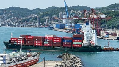
CONTSHIP UNO
General Cargo
Current Trip
| Time Travelled | 9 days |
|---|---|
| Remaining Time | --- |
| Distance Travelled | 3077.06 nm |
| Remaining Distance | --- |
| AVG Speed | 13.3 Knots |
| MAX Speed | 15.2 Knots |
| AVG Wind | 10.5 knots |
| MAX Wind | 22.6 knots |
| MIN Temp | 21.2°C / 70.16°F |
| MAX Temp | 28.6°C / 83.48°F |
| Dybgang | 8.2 m |
| Position Modtaget | 9 d siden |
Current Position
| Longitude | --- |
|---|---|
| Latitude | --- |
| Status | Under way using engine |
| Fart | 12.6 Knots |
| Kurs | 145.9° |
| Område | Gulf of Oman |
| Station | T-AIS |
| Position Modtaget | 9 d siden |
Info
Information
The current position of CONTSHIP UNO is in Gulf of Oman with coordinates 25.25087° / 56.98091° as reported on 2025-02-08 00:36 by AIS to our vessel tracker app. The vessel's current speed is 12.6 Knots
The vessel CONTSHIP UNO (IMO: 9379026, MMSI: 636018001) is a General Cargo that was built in 2007 ( 18 år gamle ). It's sailing under the flag of [LR] Liberia.
In this page you can find informations about the vessels current position, last detected port calls, and current voyage information. If the vessels is not in coverage by AIS you will find the latest position.
The current position of CONTSHIP UNO is detected by our AIS receivers and we are not responsible for the reliability of the data. The last position was recorded while the vessel was in Coverage by the Ais receivers of our vessel tracking app.
The current draught of CONTSHIP UNO as reported by AIS is 8.2 meters
Weather
| Temperature | 26.1°C / 78.98°F |
|---|---|
| Wind Speed | 7 knots |
| Direction | 18° NNE |
| Pressure | 1010.4 hPa |
| Humidity | 79 % |
| Cloud Coverage | 27 % |
Featured Company
Last Port Calls
| Port | Arrival | Departure | Time In Port |
|---|---|---|---|
| 2025-02-06 11:47 | 2025-02-07 07:16 | 19 h | |
| 2025-02-02 10:15 | 2025-02-03 07:58 | 21 h | |
| 2025-01-23 06:10 | 2025-01-24 02:20 | 20 h | |
| 2025-01-11 18:26 | 2025-01-12 14:50 | 20 h | |
| 2025-01-06 13:52 | 2025-01-07 10:21 | 20 h | |
| 2025-01-06 11:45 | 2025-01-06 13:05 | 1 h | |
| 2025-01-04 12:33 | 2025-01-05 00:49 | 12 h | |
| 2024-12-23 14:38 | 2024-12-27 05:48 | 3 d | |
| 2024-12-04 14:04 | 2024-12-04 21:21 | 7 h | |
| 2024-12-02 17:28 | 2024-12-03 03:53 | 10 h |
Last Trips
| Origin | Departure | Destination | Arrival | Distance | |
|---|---|---|---|---|---|
| 2025-02-03 12:58 | 2025-02-06 15:47 | 833.32 nm | |||
| 2025-01-24 05:20 | 2025-02-02 15:15 | 2861.89 nm | |||
| 2025-01-12 18:50 | 2025-01-23 09:10 | 3125.59 nm | |||
| 2025-01-07 15:21 | 2025-01-11 22:26 | 834.05 nm | |||
| 2025-01-06 18:05 | 2025-01-06 18:52 | 7.25 nm | |||
| 2025-01-05 06:19 | 2025-01-06 16:45 | 269.45 nm | |||
| 2024-12-27 08:48 | 2025-01-04 18:03 | 2745.19 nm | |||
| 2024-12-05 02:51 | 2024-12-23 17:38 | 3296.96 nm | |||
| 2024-12-03 09:23 | 2024-12-04 19:34 | 421.90 nm | |||
| 2024-11-23 08:31 | 2024-12-02 22:58 | 2687.48 nm |
Events
| Tid | Hændelsen | Detaljer | Position / Dest | Info |
|---|---|---|---|---|
| 2025-02-16 20:24 | STOP Sejllads | 10.58 nm, South East of MOMBASA |
-4.12936 / 39.79680
KEMBA
|
Fart: 0.3 kn Kurs: 345° |
| 2025-02-08 00:44 | Status er ændret | Default Under way using engine |
25.22925 / 56.99605
KEMBA
|
Fart: 12.6 kn Kurs: 145.9° |
| 2025-02-08 00:36 | Status er ændret | Under way using engine Default |
25.25087 / 56.98091
KEMBA
|
Fart: 12.7 kn Kurs: 147° |
| 2025-02-08 00:36 | Udenfor Dækning |
25.25087 / 56.98091
Gulf of Oman
KEMBA
|
Fart: 12.6 kn Kurs: 145.9° |
|
| 2025-02-08 00:23 | Status er ændret | Default Under way using engine |
25.29229 / 56.95163
KEMBA
|
Fart: 12.7 kn Kurs: 149.1° |
| 2025-02-07 22:26 | Ændre havområde | United Arab Emirates part of the Gulf of Oman Omani part of the Gulf of Oman |
25.66493 / 56.73392
Gulf of Oman
KEMBA
|
Fart: 12.7 kn Kurs: 149.5° |
| 2025-02-07 21:08 | Ændre havområde | Omani part of the Gulf of Oman Omani part of the Persian Gulf |
25.92474 / 56.68943
Gulf of Oman
KEMBA
|
Fart: 12.1 kn Kurs: 180.2° |
| 2025-02-07 21:07 | Status er ændret | Under way using engine Default |
25.92634 / 56.68948
KEMBA
|
Fart: 12 kn Kurs: 181° |
| 2025-02-07 20:57 | Indenfor Dækning |
25.92474 / 56.68943
Gulf of Oman
KEMBA
|
Fart: 12.1 kn Kurs: 180.2° |
|
| 2025-02-07 14:37 | Udenfor Dækning |
26.21294 / 55.92060
Persian Gulf
KEMBA
|
Fart: 12.7 kn Kurs: 42.7° |