
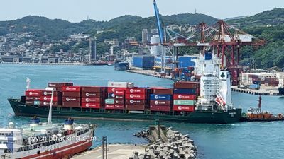
CONTSHIP UNO
General Cargo
Current Trip
| Time Travelled | 1 day |
|---|---|
| Remaining Time | --- |
| Distance Travelled | 309.71 nm |
| Remaining Distance | 14.52 nm |
| AVG Speed | 11.7 Knots |
| MAX Speed | 14.6 Knots |
| AVG Wind | 4.4 knots |
| MAX Wind | 9 knots |
| MIN Temp | 24.5°C / 76.1°F |
| MAX Temp | 26.9°C / 80.42°F |
| Draught | 8 m |
| Position Received | 3 m ago |
Current Position
| Longitude | 54.81078° |
|---|---|
| Latitude | 25.11147° |
| Status | At anchor |
| Speed | |
| Course | 10° |
| Area | Persian Gulf |
| Station | T-AIS |
| Position Received | 3 m ago |
Info
Information
The current position of CONTSHIP UNO is in Persian Gulf with coordinates 25.11147° / 54.81078° as reported on 2024-04-20 00:33 by AIS to our vessel tracker app. The vessel's current speed is 0 Knots and is heading at the port of JEBEL ALI. The estimated time of arrival as calculated by MyShipTracking vessel tracking app is 2024-04-19 11:00 LT
The vessel CONTSHIP UNO (IMO: 9379026, MMSI: 636018001) is a General Cargo that was built in 2007 ( 17 years old ). It's sailing under the flag of [LR] Liberia.
In this page you can find informations about the vessels current position, last detected port calls, and current voyage information. If the vessels is not in coverage by AIS you will find the latest position.
The current position of CONTSHIP UNO is detected by our AIS receivers and we are not responsible for the reliability of the data. The last position was recorded while the vessel was in Coverage by the Ais receivers of our vessel tracking app.
The current draught of CONTSHIP UNO as reported by AIS is 8 meters
Weather
| Temperature | 25.2°C / 77.36°F |
|---|---|
| Wind Speed | 1 knots |
| Direction | 25° NNE |
| Pressure | 1007 hPa |
| Humidity | 65.1 % |
| Cloud Coverage | --- |
Featured Company
Last Port Calls
| Port | Arrival | Departure | Time In Port |
|---|---|---|---|
| 2024-04-18 05:20 | 2024-04-18 10:58 | 5 h | |
| 2024-04-15 11:17 | 2024-04-17 09:48 | 1 d | |
| 2024-04-12 14:52 | 2024-04-13 18:14 | 1 d | |
| 2024-04-10 21:15 | 2024-04-11 06:49 | 9 h | |
| 2024-04-05 11:01 | 2024-04-10 01:25 | 4 d | |
| 2024-04-02 10:05 | 2024-04-03 06:15 | 20 h | |
| 2024-03-27 16:20 | 2024-03-28 03:23 | 11 h | |
| 2024-03-25 22:21 | 2024-03-26 21:45 | 23 h | |
| 2024-03-21 20:29 | 2024-03-23 03:14 | 1 d | |
| 2024-03-15 21:50 | 2024-03-16 04:48 | 6 h |
Last Trips
| Origin | Departure | Destination | Arrival | Distance | |
|---|---|---|---|---|---|
| 2024-04-17 12:48 | 2024-04-18 08:20 | 259.06 nm | |||
| 2024-04-13 22:14 | 2024-04-15 14:17 | 509.42 nm | |||
| 2024-04-11 09:49 | 2024-04-12 18:52 | 335.20 nm | |||
| 2024-04-10 04:25 | 2024-04-11 00:15 | 244.09 nm | |||
| 2024-04-03 10:15 | 2024-04-05 14:01 | 511.71 nm | |||
| 2024-03-28 06:23 | 2024-04-02 14:05 | 344.73 nm | |||
| 2024-03-27 00:45 | 2024-03-27 19:20 | 247.67 nm | |||
| 2024-03-23 07:14 | 2024-03-26 01:21 | 508.99 nm | |||
| 2024-03-16 07:48 | 2024-03-22 00:29 | 337.48 nm | |||
| 2024-03-15 14:33 | 2024-03-16 00:50 | 133.14 nm |
Events
| Time | Event | Details | Position / Dest | Info |
|---|---|---|---|---|
| 2024-04-19 21:45 | Status Changed | At anchor Default |
25.11174 / 54.81044
SAJUB>AEJEA
|
Speed: Course: 41° |
| 2024-04-19 21:42 | Status Changed | Default At anchor |
25.11177 / 54.81039
SAJUB>AEJEA
|
Speed: Course: 42° |
| 2024-04-19 19:09 | Status Changed | At anchor Default |
25.11158 / 54.81053
SAJUB>AEJEA
|
Speed: Course: 26° |
| 2024-04-19 19:03 | Status Changed | Default At anchor |
25.11151 / 54.81059
SAJUB>AEJEA
|
Speed: Course: 26° |
| 2024-04-19 11:55 | Status Changed | At anchor Under way using engine |
25.11358 / 54.81283
SAJUB>AEJEA
|
Speed: 0.3 kn Course: 240° |
| 2024-04-19 11:43 | STOP Moving | 13.24 nm, North of GHANTOOT |
25.11262 / 54.81057
SAJUB>AEJEA
|
Speed: 0.3 kn Course: 259° |
| 2024-04-19 06:31 | Detected in Sea | United Arab Emirates part of the Persian Gulf |
25.61085 / 53.91994
Persian Gulf
SAJUB>AEJEA
|
Speed: 12.6 kn Course: 127.1° |
| 2024-04-19 05:15 | IN Coverage |
25.78233 / 53.68097
Persian Gulf
SAJUB>AEJEA
|
Speed: 13.1 kn Course: 131.6° |
|
| 2024-04-19 01:37 | OUT of Coverage |
26.17053 / 52.89480
Persian Gulf
SAJUB>AEJEA
|
Speed: 13.5 kn Course: 105.3° |
|
| 2024-04-19 00:06 | Change Sea Area | Iranian part of the Persian Gulf Qatari part of the Persian Gulf |
26.26588 / 52.54483
Persian Gulf
SAJUB>AEJEA
|
Speed: 13.4 kn Course: 106.6° |