

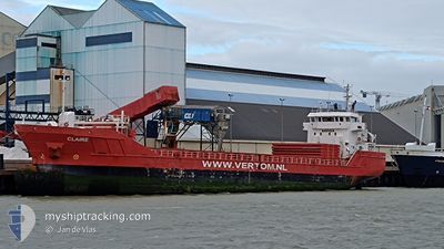
CLAIRE
General Cargo

Current Trip
| Time Travelled | 6 days |
|---|---|
| Remaining Time | 41 mins |
| Distance Travelled | 1171.30 nm |
| Remaining Distance | 9.35 nm |
| AVG Speed | 8.8 Knots |
| MAX Speed | 14.3 Knots |
| AVG Wind | 20.7 knots |
| MAX Wind | 41 knots |
| MIN Temp | 2.1°C / 35.78°F |
| MAX Temp | 14.9°C / 58.82°F |
| Dybgang | 6.2 m |
| Position Modtaget | Nu |
Current Position
| Longitude | --- |
|---|---|
| Latitude | --- |
| Status | Under way using engine |
| Fart | 0.7 Knots |
| Kurs | 293° |
| Område | North Atlantic Ocean |
| Station | T-AIS |
| Position Modtaget | Nu |
Information
The current position of CLAIRE is in North Atlantic Ocean with coordinates 38.37924° / -8.99384° as reported on 2025-03-23 09:52 by AIS to our vessel tracker app. The vessel's current speed is 0.7 Knots and is heading at the port of SETUBAL. The estimated time of arrival as calculated by MyShipTracking vessel tracking app is 2025-03-23 10:33 LT
The vessel CLAIRE (IMO: 9556301, MMSI: 244790234) is a General Cargo that was built in 2013 ( 12 år gamle ). It's sailing under the flag of [NL] Netherlands.
In this page you can find informations about the vessels current position, last detected port calls, and current voyage information. If the vessels is not in coverage by AIS you will find the latest position.
The current position of CLAIRE is detected by our AIS receivers and we are not responsible for the reliability of the data. The last position was recorded while the vessel was in Coverage by the Ais receivers of our vessel tracking app.
The current draught of CLAIRE as reported by AIS is 6.2 meters
Weather
| Temperature | 10.8°C / 51.44°F |
|---|---|
| Wind Speed | 14 knots |
| Direction | 345° NNW |
| Pressure | 1013.8 hPa |
| Humidity | 73 % |
| Cloud Coverage | 14 % |


Featured Company
Last Port Calls
| Port | Arrival | Departure | Time In Port |
|---|---|---|---|
| 2025-03-15 14:17 | 2025-03-17 05:29 | 1 d | |
| 2025-03-06 06:58 | 2025-03-14 01:31 | 7 d | |
| 2025-03-06 05:59 | 2025-03-06 06:31 | 32 m | |
| 2025-03-03 07:08 | 2025-03-04 14:50 | 1 d | |
| 2025-02-28 17:09 | 2025-03-01 21:44 | 1 d | |
| 2025-02-26 09:37 | 2025-02-28 14:35 | 2 d | |
| 2025-02-17 19:15 | 2025-02-20 00:16 | 2 d | |
| 2025-02-09 23:13 | 2025-02-15 08:42 | 5 d | |
| 2025-02-03 08:43 | 2025-02-06 09:29 | 3 d | |
| 2025-01-28 16:58 | 2025-01-30 01:04 | 1 d |
Most Visited Ports (Last year)
| Port | Arrivals | |
|---|---|---|
| 4 | ||
| 4 | ||
| 3 | ||
| 3 | ||
| 2 | ||
| 2 |
Last Trips
| Origin | Departure | Destination | Arrival | Distance | |
|---|---|---|---|---|---|
| 2025-03-14 01:31 | 2025-03-15 14:17 | 316.76 nm | |||
| 2025-03-06 06:31 | 2025-03-06 06:58 | 1.44 nm | |||
| 2025-03-04 14:50 | 2025-03-06 05:59 | 370.85 nm | |||
| 2025-03-01 21:44 | 2025-03-03 07:08 | 265.75 nm | |||
| 2025-02-28 14:35 | 2025-02-28 17:09 | 24.86 nm | |||
| 2025-02-20 00:16 | 2025-02-26 09:37 | 1425.27 nm | |||
| 2025-02-15 08:42 | 2025-02-17 19:15 | 458.70 nm | |||
| 2025-02-06 09:29 | 2025-02-09 23:13 | 817.57 nm | |||
| 2025-01-30 01:04 | 2025-02-03 08:43 | 967.87 nm | |||
| 2025-01-21 18:43 | 2025-01-28 16:58 | 1646.59 nm |
Events
| Tid | Hændelsen | Detaljer | Position / Dest | Info |
|---|---|---|---|---|
| 2025-03-23 09:40 | STOP Sejllads | 9.78 nm, South West of SETUBAL |
38.38078 / -8.99161
PTSET
|
Fart: 0.3 kn Kurs: 281° |
| 2025-03-23 08:50 | START Sejllads | 13.7 nm, South West of SETUBAL |
38.32365 / -9.03395
PTSET
|
Fart: 5.1 kn Kurs: 19.7° |
| 2025-03-23 08:38 | STOP Sejllads | 13.8 nm, South West of SETUBAL |
38.32176 / -9.03430
PTSET
|
Fart: 0.3 kn Kurs: 309° |
| 2025-03-23 05:13 | START Sejllads | 16.09 nm, South West of SETUBAL |
38.33717 / -9.12366
PTSET
|
Fart: 3.1 kn Kurs: 193° |
| 2025-03-23 01:32 | STOP Sejllads | 13.04 nm, South West of SETUBAL |
38.33876 / -9.03561
PTSET
|
Fart: 0.3 kn Kurs: 270° |
| 2025-03-22 19:14 | ETA er ændret | 2025/03/23 05:00 2025/03/22 08:00 |
38.50944 / -9.77368
PTSET
|
Fart: 9.3 kn Kurs: 107.1° |
| 2025-03-22 19:08 | Status er ændret | Under way using engine Default |
38.51418 / -9.79115
PTSET
|
Fart: 9.2 kn Kurs: 100° |
| 2025-03-22 19:08 | Status er ændret | Default Under way using engine |
38.51468 / -9.79331
PTSET
|
Fart: 9.1 kn Kurs: 109.8° |
| 2025-03-22 18:25 | Status er ændret | Under way using engine Default |
38.54915 / -9.92918
PTSET
|
Fart: 9.5 kn Kurs: 114° |
| 2025-03-22 17:51 | Status er ændret | Default Under way using engine |
38.57859 / -10.03414
PTSET
|
Fart: 9.2 kn Kurs: 164.4° |