

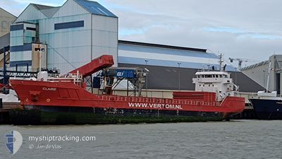
CLAIRE
General Cargo
Current Trip
| Time Travelled | 4 days |
|---|---|
| Remaining Time | --- |
| Distance Travelled | 979.96 nm |
| Remaining Distance | 242.84 nm |
| AVG Speed | 9.7 Noeuds |
| MAX Speed | 14.3 Noeuds |
| AVG Wind | 16.7 knots |
| MAX Wind | 41 knots |
| MIN Temp | 2.1°C / 35.78°F |
| MAX Temp | 14.9°C / 58.82°F |
| Tirant d eau | 6.2 m |
| Position reçue | 3 d depuis |
Current Position
| Longitude | --- |
|---|---|
| Latitude | --- |
| Etat | Under way using engine |
| Vitesse | 10.1 Noeuds |
| Parcours | 241.8° |
| Zone | Celtic Sea |
| Station | T-AIS |
| Position reçue | 3 d depuis |
Information
The current position of CLAIRE is in Celtic Sea with coordinates 49.05083° / -5.31676° as reported on 2025-03-18 22:15 by AIS to our vessel tracker app. The vessel's current speed is 10.1 Noeuds and is heading at the port of SETUBAL. The estimated time of arrival as calculated by MyShipTracking vessel tracking app is 2025-03-22 08:00 LT
The vessel CLAIRE (IMO: 9556301, MMSI: 244790234) is a General Cargo that was built in 2013 ( 12 Age ). It's sailing under the flag of [NL] Netherlands.
In this page you can find informations about the vessels current position, last detected port calls, and current voyage information. If the vessels is not in coverage by AIS you will find the latest position.
The current position of CLAIRE is detected by our AIS receivers and we are not responsible for the reliability of the data. The last position was recorded while the vessel was in Coverage by the Ais receivers of our vessel tracking app.
The current draught of CLAIRE as reported by AIS is 6.2 meters
Weather
| Temperature | 11.9°C / 53.42°F |
|---|---|
| Wind Speed | 41 knots |
| Direction | 303° WNW |
| Pressure | 1006.4 hPa |
| Humidity | 90.9 % |
| Cloud Coverage | 100 % |
Featured Company
Last Port Calls
| Port | Arrival | Departure | Time In Port |
|---|---|---|---|
| 2025-03-15 14:17 | 2025-03-17 05:29 | 1 d | |
| 2025-03-06 06:58 | 2025-03-14 01:31 | 7 d | |
| 2025-03-06 05:59 | 2025-03-06 06:31 | 32 m | |
| 2025-03-03 07:08 | 2025-03-04 14:50 | 1 d | |
| 2025-02-28 17:09 | 2025-03-01 21:44 | 1 d | |
| 2025-02-26 09:37 | 2025-02-28 14:35 | 2 d | |
| 2025-02-17 19:15 | 2025-02-20 00:16 | 2 d | |
| 2025-02-09 23:13 | 2025-02-15 08:42 | 5 d | |
| 2025-02-03 08:43 | 2025-02-06 09:29 | 3 d | |
| 2025-01-28 16:58 | 2025-01-30 01:04 | 1 d |
Last Trips
| Origin | Departure | Destination | Arrival | Distance | |
|---|---|---|---|---|---|
| 2025-03-14 01:31 | 2025-03-15 14:17 | 316.76 nm | |||
| 2025-03-06 06:31 | 2025-03-06 06:58 | 1.44 nm | |||
| 2025-03-04 14:50 | 2025-03-06 05:59 | 370.85 nm | |||
| 2025-03-01 21:44 | 2025-03-03 07:08 | 265.75 nm | |||
| 2025-02-28 14:35 | 2025-02-28 17:09 | 24.86 nm | |||
| 2025-02-20 00:16 | 2025-02-26 09:37 | 1425.27 nm | |||
| 2025-02-15 08:42 | 2025-02-17 19:15 | 458.70 nm | |||
| 2025-02-06 09:29 | 2025-02-09 23:13 | 817.57 nm | |||
| 2025-01-30 01:04 | 2025-02-03 08:43 | 967.87 nm | |||
| 2025-01-21 18:43 | 2025-01-28 16:58 | 1646.59 nm |
Events
| Heure | Evenement | Détails | Position/ Destination | Info |
|---|---|---|---|---|
| 2025-03-18 22:29 | Etat Changé | Default Under way using engine |
49.03121 / -5.36940
PTSET
|
Vitesse: 10.1 kn Parcours: 241.8° |
| 2025-03-18 22:15 | Etat Changé | Under way using engine Default |
49.05083 / -5.31676
PTSET
|
Vitesse: 9.9 kn Parcours: 240° |
| 2025-03-18 22:15 | Hors de la zone couverte |
49.05083 / -5.31676
Celtic Sea
PTSET
|
Vitesse: 10.1 kn Parcours: 241.8° |
|
| 2025-03-18 21:57 | Etat Changé | Default Under way using engine |
49.07440 / -5.25273
PTSET
|
Vitesse: 9.9 kn Parcours: 239.4° |
| 2025-03-18 21:53 | Etat Changé | Under way using engine Default |
49.08003 / -5.23759
PTSET
|
Vitesse: 9.7 kn Parcours: 240° |
| 2025-03-18 21:41 | Etat Changé | Default Under way using engine |
49.09745 / -5.19147
PTSET
|
Vitesse: 9.6 kn Parcours: 241.1° |
| 2025-03-18 21:07 | Detecté en mer | French part of the Celtic Sea |
49.14038 / -5.07467
Celtic Sea
PTSET
|
Vitesse: 9.2 kn Parcours: 241.9° |
| 2025-03-18 21:07 | Etat Changé | Under way using engine Default |
49.14038 / -5.07467
PTSET
|
Vitesse: 9.2 kn Parcours: 243° |
| 2025-03-18 21:07 | Dans la zone couverte |
49.14038 / -5.07467
Celtic Sea
PTSET
|
Vitesse: 9.2 kn Parcours: 241.9° |
|
| 2025-03-18 02:27 | Hors de la zone couverte |
50.36960 / -.78806
English Channel
PTSET
|
Vitesse: 11.2 kn Parcours: 251.5° |