
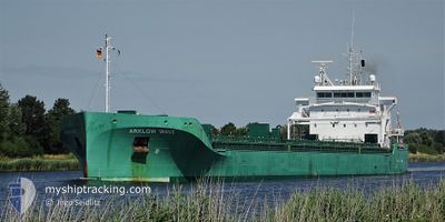
ARKLOW WAVE
Cargo
Current Trip
| Time Travelled | 2 days |
|---|---|
| Remaining Time | --- |
| Distance Travelled | 606.88 nm |
| Remaining Distance | --- |
| AVG Speed | 10.1 Knots |
| MAX Speed | 14.1 Knots |
| AVG Wind | 13.4 knots |
| MAX Wind | 27.5 knots |
| MIN Temp | 12.3°C / 54.14°F |
| MAX Temp | 19.7°C / 67.46°F |
| Dybgang | 9 m |
| Position Modtaget | Nu |
Current Position
| Longitude | 0.47423° |
|---|---|
| Latitude | 50.43002° |
| Status | Under way using engine |
| Fart | 8.5 Knots |
| Kurs | 73.7° |
| Område | English Channel |
| Station | T-AIS |
| Position Modtaget | Nu |
Info
Information
The current position of ARKLOW WAVE is in English Channel with coordinates 50.43002° / 0.47423° as reported on 2024-05-11 05:18 by AIS to our vessel tracker app. The vessel's current speed is 8.5 Knots and is heading at the port of PORSGRUNN. The estimated time of arrival as calculated by MyShipTracking vessel tracking app is 2024-05-13 15:00 LT
The vessel ARKLOW WAVE (IMO: 9818931, MMSI: 250005382) is a Cargo It's sailing under the flag of [IE] Ireland.
In this page you can find informations about the vessels current position, last detected port calls, and current voyage information. If the vessels is not in coverage by AIS you will find the latest position.
The current position of ARKLOW WAVE is detected by our AIS receivers and we are not responsible for the reliability of the data. The last position was recorded while the vessel was in Coverage by the Ais receivers of our vessel tracking app.
The current draught of ARKLOW WAVE as reported by AIS is 9 meters
Weather
| Temperature | 12.5°C / 54.5°F |
|---|---|
| Wind Speed | 12 knots |
| Direction | 55° NE |
| Pressure | 1020.2 hPa |
| Humidity | 91.9 % |
| Cloud Coverage | 41 % |
Featured Company
Last Port Calls
| Port | Arrival | Departure | Time In Port |
|---|---|---|---|
| 2024-05-05 08:54 | 2024-05-08 17:46 | 3 d | |
| 2024-04-27 13:35 | 2024-05-03 19:09 | 6 d | |
| 2024-04-27 13:05 | 2024-04-27 13:21 | 15 m | |
| 2024-04-14 20:19 | 2024-04-21 04:16 | 6 d | |
| 2024-04-12 04:52 | 2024-04-14 19:33 | 2 d | |
| 2024-04-08 00:26 | 2024-04-09 13:03 | 1 d | |
| 2024-03-26 16:15 | 2024-03-28 01:26 | 1 d | |
| 2024-03-20 20:22 | 2024-03-22 17:25 | 1 d | |
| 2024-03-12 15:59 | 2024-03-19 23:55 | 7 d | |
| 2024-03-12 15:44 | 2024-03-12 15:52 | 8 m |
Last Trips
| Origin | Departure | Destination | Arrival | Distance | |
|---|---|---|---|---|---|
| 2024-05-03 21:09 | 2024-05-05 10:54 | 371.34 nm | |||
| 2024-04-27 15:21 | 2024-04-27 15:35 | 0.27 nm | |||
| 2024-04-21 06:16 | 2024-04-27 15:05 | 575.52 nm | |||
| 2024-04-14 21:33 | 2024-04-14 22:19 | 8.30 nm | |||
| 2024-04-09 14:03 | 2024-04-12 06:52 | 631.45 nm | |||
| 2024-03-28 01:26 | 2024-04-08 01:26 | 814.03 nm | |||
| 2024-03-22 18:25 | 2024-03-26 16:15 | 962.79 nm | |||
| 2024-03-20 00:55 | 2024-03-20 21:22 | 270.76 nm | |||
| 2024-03-12 16:52 | 2024-03-12 16:59 | 0.20 nm | |||
| 2024-03-09 09:55 | 2024-03-12 16:44 | 560.21 nm |
Events
| Tid | Hændelsen | Detaljer | Position / Dest | Info |
|---|---|---|---|---|
| 2024-05-10 22:50 | Ændre havområde | United Kingdom part of the English Channel French part of the English Channel |
50.13798 / -1.08742
English Channel
HEROYA
|
Fart: 13 kn Kurs: 73.6° |
| 2024-05-10 20:05 | Fundet i havområde | French part of the English Channel |
49.96528 / -2.02220
English Channel
HEROYA
|
Fart: 13.4 kn Kurs: 74.5° |
| 2024-05-10 12:53 | Ændre havområde | Guernsey part of the English Channel French part of the English Channel |
49.50977 / -3.64963
English Channel
HEROYA
|
Fart: 8.4 kn Kurs: 62.4° |
| 2024-05-10 06:59 | Ændre havområde | French part of the English Channel French part of the Celtic Sea |
49.03648 / -4.88343
English Channel
HEROYA
|
Fart: 11.3 kn Kurs: 59.3° |
| 2024-05-10 04:06 | Status er ændret | Under way using engine Default |
48.74385 / -5.60628
HEROYA
|
Fart: 11.8 kn Kurs: 29° |
| 2024-05-10 03:54 | Status er ændret | Default Under way using engine |
48.71095 / -5.63383
HEROYA
|
Fart: 11.8 kn Kurs: 29.4° |
| 2024-05-10 01:16 | Status er ændret | Under way using engine Default |
48.24797 / -5.93347
HEROYA
|
Fart: 11 kn Kurs: 20° |
| 2024-05-10 01:14 | Status er ændret | Default Under way using engine |
48.24166 / -5.93667
HEROYA
|
Fart: 10.6 kn Kurs: 19.4° |
| 2024-05-09 23:20 | Status er ændret | Under way using engine Default |
47.94873 / -6.10103
HEROYA
|
Fart: 9.4 kn Kurs: 20° |
| 2024-05-09 23:18 | Status er ændret | Default Under way using engine |
47.94381 / -6.10360
HEROYA
|
Fart: 9.2 kn Kurs: 20.4° |