
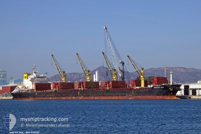
WINTER SEA
Bulk Carrier
Current Trip
| Time Travelled | 2 days |
|---|---|
| Remaining Time | --- |
| Distance Travelled | 336.38 nm |
| Remaining Distance | --- |
| AVG Speed | 11.9 Knots |
| MAX Speed | 13.4 Knots |
| AVG Wind | 11.7 knots |
| MAX Wind | 14.8 knots |
| MIN Temp | 24°C / 75.2°F |
| MAX Temp | 26.8°C / 80.24°F |
| Draught | 7.5 m |
| Position Received | 1 d ago |
Current Position
| Longitude | -97.07304° |
|---|---|
| Latitude | 27.84277° |
| Status | Moored |
| Speed | |
| Course | 77° |
| Area | Gulf of Mexico |
| Station | T-AIS |
| Position Received | 1 d ago |
Info
Information
The current position of WINTER SEA is in Gulf of Mexico with coordinates 27.84277° / -97.07304° as reported on 2024-05-01 00:46 by AIS to our vessel tracker app. The vessel's current speed is 0 Knots
The vessel WINTER SEA (IMO: 9639787, MMSI: 538004923) is a Bulk Carrier that was built in 2014 ( 10 years old ). It's sailing under the flag of [MH] Marshall Is.
In this page you can find informations about the vessels current position, last detected port calls, and current voyage information. If the vessels is not in coverage by AIS you will find the latest position.
The current position of WINTER SEA is detected by our AIS receivers and we are not responsible for the reliability of the data. The last position was recorded while the vessel was in Coverage by the Ais receivers of our vessel tracking app.
The current draught of WINTER SEA as reported by AIS is 7.5 meters
Weather
| Temperature | 24.5°C / 76.1°F |
|---|---|
| Wind Speed | 18 knots |
| Direction | 121° ESE |
| Pressure | 1006 hPa |
| Humidity | 92.2 % |
| Cloud Coverage | 100 % |
Featured Company
Last Port Calls
| Port | Arrival | Departure | Time In Port |
|---|---|---|---|
| 2024-04-26 18:51 | 2024-04-29 19:32 | 3 d | |
| 2024-03-12 23:57 | 2024-03-15 11:19 | 2 d | |
| 2024-03-04 08:28 | 2024-03-12 14:20 | 8 d |
Most Visited Ports (Last year)
| Port | Arrivals | |
|---|---|---|
| 1 | ||
| 1 | ||
| 1 | ||
| 1 | ||
| 1 | ||
| 1 |
Last Trips
| Origin | Departure | Destination | Arrival | Distance | |
|---|---|---|---|---|---|
| 2024-03-15 20:19 | 2024-04-26 13:51 | 10716.50 nm | |||
| 2024-03-12 23:20 | 2024-03-13 08:57 | 52.94 nm | |||
| 2024-02-26 13:19 | 2024-03-04 17:28 | 971.26 nm |
Events
| Time | Event | Details | Position / Dest | Info |
|---|---|---|---|---|
| 2024-05-01 00:49 | Status Changed | Default Moored |
27.84275 / -97.07305
US CRP
|
Speed: Course: 77° |
| 2024-05-01 00:46 | OUT of Coverage |
27.84277 / -97.07304
Gulf of Mexico
US CRP
|
Speed: Course: 306° |
|
| 2024-05-01 00:31 | Status Changed | Moored Default |
27.84277 / -97.07306
US CRP
|
Speed: Course: 77° |
| 2024-05-01 00:13 | Status Changed | Default Moored |
27.84276 / -97.07307
US CRP
|
Speed: Course: 77° |
| 2024-05-01 00:10 | Detected in Sea | United States part of the Gulf of Mexico |
27.84276 / -97.07309
Gulf of Mexico
US CRP
|
Speed: Course: 306° |
| 2024-05-01 00:10 | Status Changed | Moored Default |
27.84276 / -97.07309
US CRP
|
Speed: Course: 77° |
| 2024-05-01 00:10 | IN Coverage |
27.84276 / -97.07309
Gulf of Mexico
US CRP
|
Speed: Course: 306° |
|
| 2024-04-30 23:02 | STOP Moving | 0.33 nm, West of PORT ARANSAS |
27.84279 / -97.07308
US CRP
|
Speed: Course: 78° |
| 2024-04-29 20:51 | Status Changed | Default Under way using engine |
22.62911 / -97.63563
US CRP
|
Speed: 12.9 kn Course: 29.5° |
| 2024-04-29 20:48 | OUT of Coverage |
22.62004 / -97.64103
Gulf of Mexico
US CRP
|
Speed: 12.9 kn Course: 29.5° |