
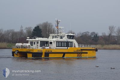
WINDCAT 42
High speed craft
Current Trip
DEMUK<>OWF BE
| Time Travelled | 3 days |
|---|---|
| Remaining Time | --- |
| Distance Travelled | 44.66 nm |
| Remaining Distance | --- |
| AVG Speed | 16.8 Knots |
| MAX Speed | 23.7 Knots |
| AVG Wind | 15.3 knots |
| MAX Wind | 21 knots |
| MIN Temp | 4°C / 39.2°F |
| MAX Temp | 5.3°C / 41.54°F |
| Draught | 2.2 m |
| Position Received | 3 d ago |
Current Position
| Longitude | --- |
|---|---|
| Latitude | --- |
| Status | Under way using engine |
| Speed | 17.1 Knots |
| Course | 198.5° |
| Area | Baltic Sea |
| Station | T-AIS |
| Position Received | 3 d ago |
Info
Information
The current position of WINDCAT 42 is in Baltic Sea with coordinates 54.64442° / 13.78047° as reported on 2025-12-29 16:06 by AIS to our vessel tracker app. The vessel's current speed is 17.1 Knots
The vessel WINDCAT 42 (MMSI: 211156470) is a High speed craft It's sailing under the flag of [DE] Germany.
In this page you can find informations about the vessels current position, last detected port calls, and current voyage information. If the vessels is not in coverage by AIS you will find the latest position.
The current position of WINDCAT 42 is detected by our AIS receivers and we are not responsible for the reliability of the data. The last position was recorded while the vessel was in Coverage by the Ais receivers of our vessel tracking app.
The current draught of WINDCAT 42 as reported by AIS is 2.2 meters
Weather
| Temperature | 3.9°C / 39.02°F |
|---|---|
| Wind Speed | 18 knots |
| Direction | 7° N |
| Pressure | 1015.2 hPa |
| Humidity | 43.2 % |
| Cloud Coverage | 72 % |
Featured Company
Events
| Time | Event | Details | Position / Dest | Info |
|---|---|---|---|---|
| 2025-12-29 16:06 | OUT of Coverage |
54.64442 / 13.78047
Baltic Sea
DEMUK<>OWF BE
|
Speed: 17.1 kn Course: 198.5° |
|
| 2025-12-29 15:29 | START Moving | 20.66 nm, North East of SASSNITZ |
54.81568 / 13.91210
DEMUK<>OWF BE
|
Speed: 11.8 kn Course: 195.3° |
| 2025-12-29 15:13 | STOP Moving | 20.76 nm, North East of SASSNITZ |
54.81756 / 13.91210
DEMUK<>OWF BE
|
Speed: 0.3 kn Course: 239° |
| 2025-12-29 15:02 | START Moving | 20.45 nm, North of SASSNITZ |
54.83345 / 13.82257
DEMUK<>OWF BE
|
Speed: 12.9 kn Course: 147.9° |
| 2025-12-29 14:44 | STOP Moving | 20.52 nm, North of SASSNITZ |
54.83510 / 13.82046
DEMUK<>OWF BE
|
Speed: 0.1 kn Course: 240° |
| 2025-12-29 14:40 | START Moving | 20.32 nm, North of SASSNITZ |
54.83138 / 13.82225
DEMUK<>OWF BE
|
Speed: 5.1 kn Course: 41.4° |
| 2025-12-29 14:36 | STOP Moving | 20.22 nm, North of SASSNITZ |
54.82955 / 13.82271
DEMUK<>OWF BE
|
Speed: 0.3 kn Course: 197° |
| 2025-12-29 13:58 | START Moving | 19.71 nm, North of SASSNITZ |
54.83006 / 13.76394
DEMUK<>OWF BE
|
Speed: 4.1 kn Course: 119° |
| 2025-12-29 12:54 | STOP Moving | 20.25 nm, North of SASSNITZ |
54.83427 / 13.79901
DEMUK<>OWF BE
|
Speed: 0.2 kn Course: 209° |
| 2025-12-29 10:16 | START Moving | 20.5 nm, North of SASSNITZ |
54.83440 / 13.82259
DEMUK<>OWF BE
|
Speed: 3.6 kn Course: 154° |