

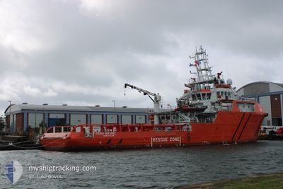
VIKING SENTINEL
Other Type

Current Trip
FISHERIES PATROL
| Time Travelled | 13 days |
|---|---|
| Remaining Time | --- |
| Distance Travelled | 924.66 nm |
| Remaining Distance | --- |
| AVG Speed | 5.3 Knots |
| MAX Speed | 10.8 Knots |
| AVG Wind | 16.7 knots |
| MAX Wind | 30 knots |
| MIN Temp | 1.9°C / 35.42°F |
| MAX Temp | 11.6°C / 52.88°F |
| Draught | 5.2 m |
| Position Received | 1 m ago |
Current Position
| Longitude | --- |
|---|---|
| Latitude | --- |
| Status | Under way using engine |
| Speed | 0.8 Knots |
| Course | 206° |
| Area | English Channel |
| Station | T-AIS |
| Position Received | 1 m ago |
Information
The current position of VIKING SENTINEL is in English Channel with coordinates 49.95498° / -3.64271° as reported on 2025-02-19 23:56 by AIS to our vessel tracker app. The vessel's current speed is 0.8 Knots
The vessel VIKING SENTINEL (IMO: 9720718, MMSI: 232042695) is a Other Type It's sailing under the flag of [GB] United Kingdom.
In this page you can find informations about the vessels current position, last detected port calls, and current voyage information. If the vessels is not in coverage by AIS you will find the latest position.
The current position of VIKING SENTINEL is detected by our AIS receivers and we are not responsible for the reliability of the data. The last position was recorded while the vessel was in Coverage by the Ais receivers of our vessel tracking app.
The current draught of VIKING SENTINEL as reported by AIS is 5.2 meters
Weather
| Temperature | 11.5°C / 52.7°F |
|---|---|
| Wind Speed | 24 knots |
| Direction | 201° SSW |
| Pressure | 1012.6 hPa |
| Humidity | 96.5 % |
| Cloud Coverage | 100 % |


Featured Company
Last Port Calls
| Port | Arrival | Departure | Time In Port |
|---|---|---|---|
| 2025-02-03 18:08 | 2025-02-06 18:29 | 3 d | |
| 2025-01-07 18:21 | 2025-01-08 18:38 | 1 d | |
| 2024-12-10 13:38 | 2024-12-11 14:26 | 1 d |
Most Visited Ports (Last year)
| Port | Arrivals | |
|---|---|---|
| 10 | ||
| 2 | ||
| 1 | ||
| 1 |
Last Trips
| Origin | Departure | Destination | Arrival | Distance | |
|---|---|---|---|---|---|
| 2025-01-08 18:38 | 2025-02-03 18:08 | 1524.66 nm | |||
| 2024-12-11 14:26 | 2025-01-07 18:21 | 980.85 nm | |||
| 2024-11-13 18:30 | 2024-12-10 13:38 | 1206.08 nm |
Events
| Time | Event | Details | Position / Dest | Info |
|---|---|---|---|---|
| 2025-02-19 23:47 | STOP Moving | 17.51 nm, South of SALCOMBE |
49.95643 / -3.64408
FISHERIES PATROL
|
Speed: 0.2 kn Course: 205° |
| 2025-02-19 16:39 | START Moving | 5.38 nm, South West of TORPOINT |
50.29562 / -4.25656
FISHERIES PATROL
|
Speed: 3.2 kn Course: 327° |
| 2025-02-19 16:11 | STOP Moving | 4.79 nm, South of TORPOINT |
50.30047 / -4.23612
FISHERIES PATROL
|
Speed: 0.3 kn Course: 130° |
| 2025-02-19 15:37 | START Moving | 5.35 nm, South West of TORPOINT |
50.29306 / -4.24634
FISHERIES PATROL
|
Speed: 3.1 kn Course: 316° |
| 2025-02-19 11:25 | STOP Moving | 5.36 nm, South of TORPOINT |
50.29065 / -4.23684
FISHERIES PATROL
|
Speed: 0.3 kn Course: 219° |
| 2025-02-19 10:16 | START Moving | 5.08 nm, South West of PLYMOUTH |
50.29183 / -4.22503
FISHERIES PATROL
|
Speed: 3.1 kn Course: 54° |
| 2025-02-19 08:59 | STOP Moving | 4.73 nm, South West of PLYMOUTH |
50.29674 / -4.21990
FISHERIES PATROL
|
Speed: 0.2 kn Course: 159° |
| 2025-02-19 08:40 | START Moving | 5.63 nm, South West of PLYMOUTH |
50.28261 / -4.22887
FISHERIES PATROL
|
Speed: 3.1 kn Course: 16° |
| 2025-02-19 07:59 | STOP Moving | 5.27 nm, South of TORPOINT |
50.29133 / -4.23324
FISHERIES PATROL
|
Speed: 0.2 kn Course: 228° |
| 2025-02-19 07:41 | START Moving | 4.69 nm, South of TORPOINT |
50.30090 / -4.23039
FISHERIES PATROL
|
Speed: 3.1 kn Course: 124° |