
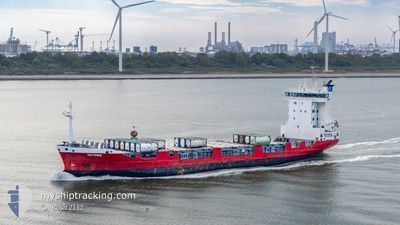
VICTORIA
Container Ship
Current Trip
| Time Travelled | 2 days |
|---|---|
| Remaining Time | 1 day |
| Distance Travelled | 684.01 nm |
| Remaining Distance | 457.73 nm |
| AVG Speed | 11.5 Knots |
| MAX Speed | 16.8 Knots |
| AVG Wind | 18.2 knots |
| MAX Wind | 25.3 knots |
| MIN Temp | 3.4°C / 38.12°F |
| MAX Temp | 17.3°C / 63.14°F |
| Draught | 6.5 m |
| Position Received | 6 h, 5 m ago |
Current Position
| Longitude | --- |
|---|---|
| Latitude | --- |
| Status | Under way using engine |
| Speed | 13.5 Knots |
| Course | 62° |
| Area | Baltic Sea |
| Station | T-AIS |
| Position Received | 6 h, 5 m ago |
Information
The current position of VICTORIA is in Baltic Sea with coordinates 56.03150° / 16.73833° as reported on 2025-03-23 23:55 by AIS to our vessel tracker app. The vessel's current speed is 13.5 Knots and is heading at the port of ST PETERSBURG. The estimated time of arrival as calculated by MyShipTracking vessel tracking app is 2025-03-25 13:36 LT
The vessel VICTORIA (IMO: 9165308, MMSI: 277550000) is a Container Ship that was built in 1998 ( 27 years old ). It's sailing under the flag of [LT] Lithuania.
In this page you can find informations about the vessels current position, last detected port calls, and current voyage information. If the vessels is not in coverage by AIS you will find the latest position.
The current position of VICTORIA is detected by our AIS receivers and we are not responsible for the reliability of the data. The last position was recorded while the vessel was in Coverage by the Ais receivers of our vessel tracking app.
The current draught of VICTORIA as reported by AIS is 6.5 meters
Weather
| Temperature | 3.4°C / 38.12°F |
|---|---|
| Wind Speed | 12 knots |
| Direction | 109° ESE |
| Pressure | 1014.9 hPa |
| Humidity | 90.4 % |
| Cloud Coverage | 3 % |
Featured Company
Last Port Calls
| Port | Arrival | Departure | Time In Port |
|---|---|---|---|
| 2025-03-21 02:04 | 2025-03-21 18:36 | 16 h | |
| 2025-03-15 16:17 | 2025-03-16 18:35 | 1 d | |
| 2025-03-04 06:21 | 2025-03-06 11:47 | 2 d | |
| 2025-03-01 21:26 | 2025-03-01 21:31 | 4 m | |
| 2025-02-26 12:38 | 2025-02-28 12:00 | 1 d | |
| 2025-02-25 05:27 | 2025-02-25 07:00 | 1 h | |
| 2025-02-21 11:25 | 2025-02-22 18:36 | 1 d | |
| 2025-02-15 15:33 | 2025-02-16 19:01 | 1 d | |
| 2025-02-09 14:49 | 2025-02-10 20:05 | 1 d | |
| 2025-02-04 11:37 | 2025-02-05 14:35 | 1 d |
Most Visited Ports (Last year)
| Port | Arrivals | |
|---|---|---|
| 34 | ||
| 32 | ||
| 22 | ||
| 3 | ||
| 2 | ||
| 1 |
Last Trips
| Origin | Departure | Destination | Arrival | Distance | |
|---|---|---|---|---|---|
| 2025-03-16 21:35 | 2025-03-21 03:04 | 1318.32 nm | |||
| 2025-03-06 14:47 | 2025-03-15 19:17 | 2634.18 nm | |||
| 2025-03-01 22:31 | 2025-03-04 09:21 | 788.25 nm | |||
| 2025-02-28 13:00 | 2025-03-01 22:26 | 333.28 nm | |||
| 2025-02-25 08:00 | 2025-02-26 13:38 | 347.04 nm | |||
| 2025-02-22 21:36 | 2025-02-25 06:27 | 789.98 nm | |||
| 2025-02-16 20:01 | 2025-02-21 14:25 | 1123.02 nm | |||
| 2025-02-10 23:05 | 2025-02-15 16:33 | 1322.61 nm | |||
| 2025-02-05 15:35 | 2025-02-09 17:49 | 1121.68 nm | |||
| 2025-01-31 12:09 | 2025-02-04 12:37 | 1137.22 nm |
Events
| Time | Event | Details | Position / Dest | Info |
|---|---|---|---|---|
| 2025-03-24 00:02 | Status Changed | Default Under way using engine |
56.04783 / 16.77500
RULED
|
Speed: 13.5 kn Course: 62° |
| 2025-03-23 23:55 | OUT of Coverage |
56.03150 / 16.73833
Baltic Sea
RULED
|
Speed: 13.5 kn Course: 62° |
|
| 2025-03-23 19:50 | Change Sea Area | Swedish part of the Baltic Sea Danish part of the Kattegat |
55.61917 / 15.37717
Baltic Sea
RULED
|
Speed: 11.8 kn Course: 59° |
| 2025-03-23 14:53 | Change Sea Area | Danish part of the Kattegat Swedish part of the Baltic Sea |
55.02950 / 14.08800
Kattegat
RULED
|
Speed: 13.1 kn Course: 69° |
| 2025-03-23 14:22 | Change Sea Area | Swedish part of the Baltic Sea German part of the Baltic Sea |
54.99350 / 13.90467
Baltic Sea
RULED
|
Speed: 13.1 kn Course: 68° |
| 2025-03-23 08:32 | Change Sea Area | German part of the Baltic Sea Danish part of the Baltic Sea |
54.40767 / 12.10017
Baltic Sea
RULED
|
Speed: 13.1 kn Course: 89° |
| 2025-03-23 06:40 | Change Sea Area | Danish part of the Baltic Sea German part of the Baltic Sea |
54.49300 / 11.45483
Baltic Sea
RULED
|
Speed: 12.2 kn Course: 120° |
| 2025-03-23 04:37 | Change Sea Area | German part of the Baltic Sea Danish part of the Baltic Sea |
54.56767 / 10.78100
Baltic Sea
RULED
|
Speed: 13.5 kn Course: 84° |
| 2025-03-23 04:10 | Change Sea Area | Danish part of the Baltic Sea German part of the Baltic Sea |
54.55667 / 10.60933
Baltic Sea
RULED
|
Speed: 13.4 kn Course: 83° |
| 2025-03-23 03:04 | Change Sea Area | German part of the Baltic Sea German part of the North Sea |
54.46367 / 10.27650
Baltic Sea
RULED
|
Speed: 13.4 kn Course: 38° |