
TRANSUND
General Cargo
Current Trip
| Time Travelled | 3 days |
|---|---|
| Remaining Time | --- |
| Distance Travelled | 932.30 nm |
| Remaining Distance | --- |
| AVG Speed | 11.2 Knots |
| MAX Speed | 12.9 Knots |
| AVG Wind | 9.2 knots |
| MAX Wind | 19 knots |
| MIN Temp | 0.5°C / 32.9°F |
| MAX Temp | 16°C / 60.8°F |
| Draught | 9.2 m |
| Position Received | 1 m ago |
Current Position
| Longitude | 11.69005° |
|---|---|
| Latitude | 57.59092° |
| Status | At anchor |
| Speed | 0.3 Knots |
| Course | 157° |
| Area | Kattegat |
| Station | T-AIS |
| Position Received | 1 m ago |
Info
Information
The current position of TRANSUND is in Kattegat with coordinates 57.59092° / 11.69005° as reported on 2024-05-12 06:56 by AIS to our vessel tracker app. The vessel's current speed is 0.3 Knots and is heading at the port of ALEXANDRIA. The estimated time of arrival as calculated by MyShipTracking vessel tracking app is 2024-05-26 06:00 LT
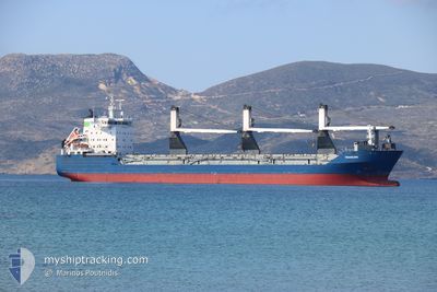
The vessel TRANSUND (IMO: 9213088, MMSI: 636022504) is a General Cargo that was built in 2002 ( 22 years old ). It's sailing under the flag of [LR] Liberia.
In this page you can find informations about the vessels current position, last detected port calls, and current voyage information. If the vessels is not in coverage by AIS you will find the latest position.
The current position of TRANSUND is detected by our AIS receivers and we are not responsible for the reliability of the data. The last position was recorded while the vessel was in Coverage by the Ais receivers of our vessel tracking app.
The current draught of TRANSUND as reported by AIS is 9.2 meters
Weather
| Temperature | 11.5°C / 52.7°F |
|---|---|
| Wind Speed | 10 knots |
| Direction | 176° S |
| Pressure | 1025.9 hPa |
| Humidity | 90.2 % |
| Cloud Coverage | 38 % |
Featured Company
Last Port Calls
| Port | Arrival | Departure | Time In Port |
|---|---|---|---|
| 2024-05-06 12:16 | 2024-05-08 22:23 | 2 d | |
| 2024-05-03 21:18 | 2024-05-05 20:54 | 1 d | |
| 2024-04-28 15:20 | 2024-05-03 13:48 | 4 d | |
| 2024-04-06 13:56 | 2024-04-12 15:21 | 6 d | |
| 2024-04-01 00:22 | 2024-04-05 02:05 | 4 d | |
| 2024-03-08 23:44 | 2024-03-14 06:29 | 5 d |
Last Trips
| Origin | Departure | Destination | Arrival | Distance | |
|---|---|---|---|---|---|
| 2024-05-05 22:54 | 2024-05-06 14:16 | 162.25 nm | |||
| 2024-05-03 15:48 | 2024-05-03 23:18 | 77.76 nm | |||
| 2024-04-12 18:21 | 2024-04-28 17:20 | 4418.74 nm | |||
| 2024-04-05 04:05 | 2024-04-06 16:56 | 451.20 nm | |||
| 2024-03-14 07:29 | 2024-04-01 02:22 | 4639.20 nm | |||
| 2024-02-09 07:55 | 2024-03-09 00:44 | 4273.67 nm |
Events
| Time | Event | Details | Position / Dest | Info |
|---|---|---|---|---|
| 2024-05-12 06:53 | STOP Moving | 2.99 nm, West of VRANGO |
57.59078 / 11.68980
EGALY
|
Speed: 0.3 kn Course: 139° |
| 2024-05-12 06:52 | Status Changed | At anchor Under way using engine |
57.59083 / 11.68947
EGALY
|
Speed: 0.6 kn Course: 132° |
| 2024-05-12 02:58 | Change Sea Area | Swedish part of the Kattegat Danish part of the Kattegat |
56.99217 / 11.76522
Kattegat
EGALY
|
Speed: 11.7 kn Course: 342.2° |
| 2024-05-11 13:37 | Change Sea Area | Danish part of the Kattegat Danish part of the Baltic Sea |
54.74600 / 10.87917
Kattegat
EGALY
|
Speed: 10.7 kn Course: 355.1° |
| 2024-05-11 12:28 | Change Sea Area | Danish part of the Baltic Sea German part of the Baltic Sea |
54.62543 / 11.14302
Baltic Sea
EGALY
|
Speed: 11.1 kn Course: 293.9° |
| 2024-05-11 12:13 | Change Sea Area | German part of the Baltic Sea Danish part of the Baltic Sea |
54.60375 / 11.21458
Baltic Sea
EGALY
|
Speed: 11.4 kn Course: 297.4° |
| 2024-05-11 09:13 | Change Sea Area | Danish part of the Baltic Sea German part of the Baltic Sea |
54.44397 / 12.14386
Baltic Sea
EGALY
|
Speed: 11.2 kn Course: 270.4° |
| 2024-05-11 08:52 | Change Sea Area | German part of the Baltic Sea Danish part of the Baltic Sea |
54.48678 / 12.20811
Baltic Sea
EGALY
|
Speed: 11.3 kn Course: 194.8° |
| 2024-05-11 07:35 | Detected in Sea | Danish part of the Baltic Sea |
54.67801 / 12.42540
Baltic Sea
EGALY
|
Speed: 11.6 kn Course: 238.2° |
| 2024-05-11 07:26 | Change Sea Area | German part of the Baltic Sea Danish part of the Baltic Sea |
54.69355 / 12.46796
Baltic Sea
EGALY
|
Speed: 11.6 kn Course: 237.9° |