
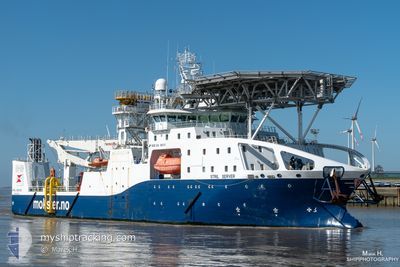
STRIL SERVER
Offshore Supply Ship
Current Trip
| Trip Time | 5 days |
|---|---|
| Trip Distance | 193.99 nm |
| AVG Speed | 7.1 Knots |
| MAX Speed | 10 Knots |
| Draught | 4.6 m |
| AVG Wind | 13.1 knots |
| MAX Wind | 30 knots |
| MIN Temp | 4.6°C / 40.28°F |
| MAX Temp | 8.2°C / 46.76°F |
| Position Received | 4 m ago |
Current Position
| Longitude | --- |
|---|---|
| Latitude | --- |
| Status | Moored |
| Speed | |
| Course | 68° |
| Area | North Sea |
| Station | T-AIS |
| Position Received | 4 m ago |
Info
Information
The current position of STRIL SERVER is in North Sea with coordinates 59.42150° / 5.25263° as reported on 2026-03-27 08:25 by AIS to our vessel tracker app. The vessel's current speed is 0 Knots and is currently inside the port of HAUGESUND.
The vessel STRIL SERVER (IMO: 9665047, MMSI: 258873000) is a Offshore Supply Ship It's sailing under the flag of [NO] Norway.
In this page you can find informations about the vessels current position, last detected port calls, and current voyage information. If the vessels is not in coverage by AIS you will find the latest position.
The current position of STRIL SERVER is detected by our AIS receivers and we are not responsible for the reliability of the data. The last position was recorded while the vessel was in Coverage by the Ais receivers of our vessel tracking app.
The current draught of STRIL SERVER as reported by AIS is 4.6 meters
Weather
| Temperature | 3°C / 37.4°F |
|---|---|
| Wind Speed | 19 knots |
| Direction | 156° SSE |
| Pressure | 1009.9 hPa |
| Humidity | 87.9 % |
| Cloud Coverage | 100 % |
Featured Company
Last Port Calls
| Port | Arrival | Departure | Time In Port |
|---|---|---|---|
| 2026-03-19 06:19 | |||
| 2026-03-09 02:46 | 2026-03-13 08:09 | 4 d | |
| 2026-02-28 19:22 | 2026-03-04 19:48 | 4 d | |
| 2026-02-28 16:07 | 2026-02-28 16:29 | 22 m | |
| 2026-02-28 04:31 | 2026-02-28 07:44 | 3 h | |
| 2026-02-20 01:44 | 2026-02-21 01:44 | 1 d | |
| 2026-02-13 15:30 | 2026-02-17 22:58 | 4 d | |
| 2026-02-07 17:15 | 2026-02-13 10:57 | 5 d | |
| 2026-02-04 22:14 | |||
| 2026-01-23 19:39 | 2026-02-03 14:20 | 10 d |
Last Trips
| Origin | Departure | Destination | Arrival | Distance | |
|---|---|---|---|---|---|
| 2026-03-13 08:09 | 2026-03-19 06:19 | 193.99 nm | |||
| 2026-03-04 19:48 | 2026-03-09 02:46 | 362.95 nm | |||
| 2026-02-28 16:29 | 2026-02-28 19:22 | 5.09 nm | |||
| 2026-02-28 07:44 | 2026-02-28 16:07 | 40.86 nm | |||
| 2026-02-21 01:44 | 2026-02-28 04:31 | 461.53 nm | |||
| 2026-02-17 22:58 | 2026-02-20 01:44 | 43.92 nm | |||
| 2026-02-13 10:57 | 2026-02-13 15:30 | 19.73 nm | |||
| 2026-02-04 22:14 | 2026-02-07 17:15 | 180.51 nm | |||
| 2026-01-23 18:53 | 2026-01-23 19:39 | 3.49 nm | |||
| 2025-12-18 10:17 | 2026-01-23 16:04 | 64.54 nm |
Events
| Time | Event | Details | Position / Dest | Info |
|---|---|---|---|---|
| 2026-03-19 05:58 | Status Changed | Moored Under way using engine |
59.42182 / 5.25411
[NO] HAUGESUND
|
Speed: Course: 68° |
| 2026-03-19 05:21 | STOP Moving |
59.42161 / 5.25310
[NO] HAUGESUND
|
Speed: 0.3 kn Course: 67° |
|
| 2026-03-19 05:19 | PORT ARRIVAL |
|
59.42148 / 5.25279
[NO] HAUGESUND
|
Speed: 0.7 kn Course: 67° |
| 2026-03-18 18:13 | START Moving | --- |
58.96664 / 2.32996
KJOTTKAKE
|
Speed: 9.4 kn Course: 82.8° |
| 2026-03-18 17:57 | Status Changed | Under way using engine Restricted manoeuverability |
58.96959 / 2.28087
KJOTTKAKE
|
Speed: 0.5 kn Course: 208° |
| 2026-03-18 15:30 | IN Coverage |
58.96960 / 2.28165
North Sea
|
Speed: 0.3 kn Course: 326.8° |
|
| 2026-03-18 14:22 | OUT of Coverage |
58.96946 / 2.28082
North Sea
|
Speed: 0.2 kn Course: 122° |
|
| 2026-03-18 10:33 | IN Coverage |
58.96924 / 2.28109
North Sea
|
Speed: 0.3 kn Course: 314.2° |
|
| 2026-03-18 08:23 | OUT of Coverage |
58.96924 / 2.28111
North Sea
|
Speed: 0.3 kn Course: 128.1° |
|
| 2026-03-18 08:23 | IN Coverage |
58.96924 / 2.28111
North Sea
|
Speed: 0.3 kn Course: 128.1° |