

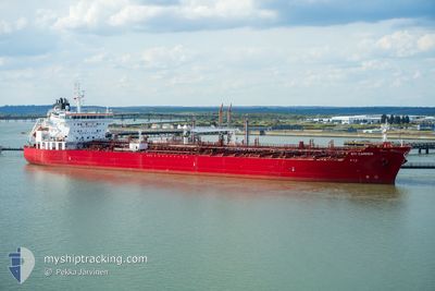
STI CAMDEN
Tanker

Current Trip
DEV POINT
| Time Travelled | 8 days |
|---|---|
| Remaining Time | --- |
| Distance Travelled | 496.75 nm |
| Remaining Distance | --- |
| AVG Speed | 8.4 Knots |
| MAX Speed | 13.3 Knots |
| AVG Wind | 13.3 knots |
| MAX Wind | 40.7 knots |
| MIN Temp | 9.6°C / 49.28°F |
| MAX Temp | 19.4°C / 66.92°F |
| Draught | 10.4 m |
| Position Received | 5 d ago |
Current Position
| Longitude | --- |
|---|---|
| Latitude | --- |
| Status | Not under command |
| Speed | 0.3 Knots |
| Course | 252° |
| Area | Mediterranean Sea - Eastern Basin |
| Station | T-AIS |
| Position Received | 5 d ago |
Information
The current position of STI CAMDEN is in Mediterranean Sea - Eastern Basin with coordinates 36.12904° / 22.53614° as reported on 2025-03-16 16:20 by AIS to our vessel tracker app. The vessel's current speed is 0.3 Knots
The vessel STI CAMDEN (IMO: 9688386, MMSI: 538005402) is a Tanker It's sailing under the flag of [MH] Marshall Is.
In this page you can find informations about the vessels current position, last detected port calls, and current voyage information. If the vessels is not in coverage by AIS you will find the latest position.
The current position of STI CAMDEN is detected by our AIS receivers and we are not responsible for the reliability of the data. The last position was recorded while the vessel was in Coverage by the Ais receivers of our vessel tracking app.
The current draught of STI CAMDEN as reported by AIS is 10.4 meters
Weather
| Temperature | 13.8°C / 56.84°F |
|---|---|
| Wind Speed | 4 knots |
| Direction | 218° SW |
| Pressure | 1024 hPa |
| Humidity | 65.6 % |
| Cloud Coverage | 18 % |


Featured Company
Last Port Calls
| Port | Arrival | Departure | Time In Port |
|---|---|---|---|
| 2025-03-09 23:40 | 2025-03-13 20:30 | 3 d | |
| 2025-02-26 10:18 | 2025-02-27 19:57 | 1 d | |
| 2025-02-22 07:45 | 2025-02-24 01:45 | 1 d | |
| 2025-02-17 11:58 | 2025-02-19 11:07 | 1 d | |
| 2025-01-26 03:58 | 2025-01-29 00:08 | 2 d | |
| 2025-01-22 22:08 | 2025-01-24 01:19 | 1 d | |
| 2025-01-20 13:45 | 2025-01-22 01:32 | 1 d | |
| 2025-01-15 23:34 | 2025-01-17 17:39 | 1 d | |
| 2025-01-10 17:41 | 2025-01-12 10:19 | 1 d | |
| 2025-01-05 15:13 | 2025-01-07 14:41 | 1 d |
Last Trips
| Origin | Departure | Destination | Arrival | Distance | |
|---|---|---|---|---|---|
| 2025-02-27 19:57 | 2025-03-09 23:40 | 1936.88 nm | |||
| 2025-02-24 01:45 | 2025-02-26 10:18 | 662.92 nm | |||
| 2025-02-19 11:07 | 2025-02-22 07:45 | 644.52 nm | |||
| 2025-01-29 00:08 | 2025-02-17 11:58 | 1923.10 nm | |||
| 2025-01-24 01:19 | 2025-01-26 03:58 | 311.41 nm | |||
| 2025-01-22 01:32 | 2025-01-22 22:08 | 194.57 nm | |||
| 2025-01-17 17:39 | 2025-01-20 13:45 | 704.48 nm | |||
| 2025-01-12 10:19 | 2025-01-15 23:34 | 902.94 nm | |||
| 2025-01-07 14:41 | 2025-01-10 17:41 | 684.03 nm | |||
| 2025-01-03 08:58 | 2025-01-05 15:13 | 704.22 nm |
Events
| Time | Event | Details | Position / Dest | Info |
|---|---|---|---|---|
| 2025-03-22 04:52 | START Moving | 9.02 nm, North East of KITHIRA |
36.35008 / 23.23124
DEV POINT
|
Speed: 3.9 kn Course: 123° |
| 2025-03-21 23:59 | STOP Moving | 7.92 nm, North East of KITHIRA |
36.32319 / 23.22393
DEV POINT
|
Speed: 0.3 kn Course: 126° |
| 2025-03-21 22:28 | START Moving | 8.8 nm, North East of KITHIRA |
36.32905 / 23.24043
DEV POINT
|
Speed: 5.8 kn Course: 289° |
| 2025-03-21 18:19 | STOP Moving | 10.97 nm, East of KITHIRA |
36.30199 / 23.29793
DEV POINT
|
Speed: 0.2 kn Course: 149° |
| 2025-03-21 10:22 | START Moving | 16 nm, West of KAPSALI |
36.06634 / 22.68777
DEV POINT
|
Speed: 5 kn Course: 95° |
| 2025-03-21 08:21 | STOP Moving | 17.53 nm, West of KAPSALI |
36.06904 / 22.65416
DEV POINT
|
Speed: 0.1 kn Course: 353° |
| 2025-03-19 04:12 | START Moving | 6.82 nm, East of AVLEMONAS |
36.25643 / 23.21726
DEV POINT
|
Speed: 5.7 kn Course: 115° |
| 2025-03-18 09:07 | STOP Moving | 7.36 nm, East of KITHIRA |
36.31326 / 23.21652
DEV POINT
|
Speed: 0.2 kn Course: 329° |
| 2025-03-18 07:01 | START Moving | 15.56 nm, East of AVLEMONAS |
36.25950 / 23.39994
DEV POINT
|
Speed: 3.5 kn Course: 281° |
| 2025-03-18 03:16 | STOP Moving | 14.61 nm, East of AVLEMONAS |
36.23133 / 23.38301
DEV POINT
|
Speed: 0.3 kn Course: 358° |