
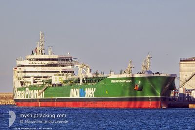
STENA PROGRESSIVE
Tanker
Current Trip
| Time Travelled | 6 days |
|---|---|
| Remaining Time | --- |
| Distance Travelled | 329.09 nm |
| Remaining Distance | --- |
| AVG Speed | 10.4 Knots |
| MAX Speed | 12.6 Knots |
| AVG Wind | 7.2 knots |
| MAX Wind | 21 knots |
| MIN Temp | 20.9°C / 69.62°F |
| MAX Temp | 23.5°C / 74.3°F |
| Draught | 7.9 m |
| Position Received | 2 d ago |
Current Position
| Longitude | --- |
|---|---|
| Latitude | --- |
| Status | Under way using engine |
| Speed | 11.7 Knots |
| Course | 42.5° |
| Area | Persian Gulf |
| Station | T-AIS |
| Position Received | 2 d ago |
Info
Information
The current position of STENA PROGRESSIVE is in Persian Gulf with coordinates 26.11008° / 55.75905° as reported on 2026-01-06 19:39 by AIS to our vessel tracker app. The vessel's current speed is 11.7 Knots
The vessel STENA PROGRESSIVE (IMO: 9944649, MMSI: 210324000) is a Tanker It's sailing under the flag of [CY] Cyprus.
In this page you can find informations about the vessels current position, last detected port calls, and current voyage information. If the vessels is not in coverage by AIS you will find the latest position.
The current position of STENA PROGRESSIVE is detected by our AIS receivers and we are not responsible for the reliability of the data. The last position was recorded while the vessel was in Coverage by the Ais receivers of our vessel tracking app.
The current draught of STENA PROGRESSIVE as reported by AIS is 7.9 meters
Weather
| Temperature | 20.9°C / 69.62°F |
|---|---|
| Wind Speed | 9 knots |
| Direction | 103° ESE |
| Pressure | 1017.6 hPa |
| Humidity | 70.2 % |
| Cloud Coverage | 14 % |
Featured Company
Last Port Calls
| Port | Arrival | Departure | Time In Port |
|---|---|---|---|
| 2026-01-01 05:52 | 2026-01-02 14:12 | 1 d | |
| 2025-12-29 11:53 | 2025-12-30 10:20 | 22 h | |
| 2025-12-23 19:18 | 2025-12-24 11:38 | 16 h | |
| 2025-12-09 15:18 | 2025-12-10 06:01 | 14 h | |
| 2025-11-30 01:18 | 2025-11-30 22:36 | 21 h | |
| 2025-11-26 06:30 | 2025-11-27 05:42 | 23 h | |
| 2025-11-25 02:33 | 2025-11-26 05:33 | 1 d | |
| 2025-11-23 00:05 | 2025-11-25 02:01 | 2 d | |
| 2025-11-21 02:28 | 2025-11-21 16:11 | 13 h | |
| 2025-11-19 22:17 | 2025-11-21 01:10 | 1 d |
Most Visited Ports (Last year)
| Port | Arrivals | |
|---|---|---|
| 3 | ||
| 3 | ||
| 2 | ||
| 2 | ||
| 2 | ||
| 2 |
Last Trips
| Origin | Departure | Destination | Arrival | Distance | |
|---|---|---|---|---|---|
| 2025-12-30 14:20 | 2026-01-01 09:52 | 43.24 nm | |||
| 2025-12-24 17:08 | 2025-12-29 15:53 | 1245.83 nm | |||
| 2025-12-10 14:01 | 2025-12-24 00:48 | 2519.74 nm | |||
| 2025-12-01 07:36 | 2025-12-09 23:18 | 2518.11 nm | |||
| 2025-11-27 14:42 | 2025-11-30 10:18 | 155.90 nm | |||
| 2025-11-26 14:33 | 2025-11-26 15:30 | 8.85 nm | |||
| 2025-11-25 11:01 | 2025-11-25 11:33 | 2.05 nm | |||
| 2025-11-22 01:11 | 2025-11-23 09:05 | 69.43 nm | |||
| 2025-11-21 10:10 | 2025-11-21 11:28 | 11.41 nm | |||
| 2025-11-18 06:11 | 2025-11-20 07:17 | 538.47 nm |
Events
| Time | Event | Details | Position / Dest | Info |
|---|---|---|---|---|
| 2026-01-09 08:43 | STOP Moving |
25.02500 / 56.94500
AEJEA > OMSOH
|
Speed: Course: -1° |
|
| 2026-01-09 06:01 | START Moving | 16.81 nm, East of KHAWR KALBA |
25.04155 / 56.67567
AEJEA > OMSOH
|
Speed: 4.5 kn Course: 102° |
| 2026-01-07 17:43 | STOP Moving |
24.89833 / 56.90833
AEJEA > OMSOH
|
Speed: Course: -1° |
|
| 2026-01-07 16:42 | START Moving |
24.87292 / 56.87199
AEJEA > OMSOH
|
Speed: 3.7 kn Course: 53° |
|
| 2026-01-07 16:16 | STOP Moving |
24.86500 / 56.87167
AEJEA > OMSOH
|
Speed: Course: -1° |
|
| 2026-01-06 19:45 | Status Changed | Default Under way using engine |
26.12290 / 55.77214
AEJEA > OMSOH
|
Speed: 11.7 kn Course: 42.5° |
| 2026-01-06 19:39 | OUT of Coverage |
26.11008 / 55.75905
Persian Gulf
AEJEA > OMSOH
|
Speed: 11.7 kn Course: 42.5° |
|
| 2026-01-06 18:28 | ETA Changed | 2026/01/15 12:00 2026/01/03 08:00 |
25.95065 / 55.57951
AEJEA > OMSOH
|
Speed: 11.7 kn Course: 64.6° |
| 2026-01-06 18:01 | Status Changed | Under way using engine Default |
25.90352 / 55.49921
AEJEA > OMSOH
|
Speed: 11.8 kn Course: 51° |
| 2026-01-06 17:56 | Status Changed | Default Under way using engine |
25.89365 / 55.48545
AEJEA > OMSOH
|
Speed: 11.6 kn Course: 48.2° |