
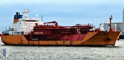
STELLA KOSAN
Lpg Tanker
Current Trip
IN CDL
| Time Travelled | 9 days |
|---|---|
| Remaining Time | --- |
| Distance Travelled | 2983.22 nm |
| Remaining Distance | --- |
| AVG Speed | 13.4 Knots |
| MAX Speed | 15.2 Knots |
| AVG Wind | 12.5 knots |
| MAX Wind | 24 knots |
| MIN Temp | 13°C / 55.4°F |
| MAX Temp | 29.3°C / 84.74°F |
| Draught | 8.9 m |
| Position Received | 3 d ago |
Current Position
| Longitude | -16.74945° |
|---|---|
| Latitude | 8.23023° |
| Status | Under way using engine |
| Speed | 14.1 Knots |
| Course | 144° |
| Area | North Atlantic Ocean |
| Station | T-AIS |
| Position Received | 3 d ago |
Info
Information
The current position of STELLA KOSAN is in North Atlantic Ocean with coordinates 8.23023° / -16.74945° as reported on 2024-04-29 02:36 by AIS to our vessel tracker app. The vessel's current speed is 14.1 Knots
The vessel STELLA KOSAN (IMO: 9373591, MMSI: 565829000) is a Lpg Tanker that was built in 2008 ( 16 years old ). It's sailing under the flag of [SG] Singapore.
In this page you can find informations about the vessels current position, last detected port calls, and current voyage information. If the vessels is not in coverage by AIS you will find the latest position.
The current position of STELLA KOSAN is detected by our AIS receivers and we are not responsible for the reliability of the data. The last position was recorded while the vessel was in Coverage by the Ais receivers of our vessel tracking app.
The current draught of STELLA KOSAN as reported by AIS is 8.9 meters
Weather
| Temperature | 27.7°C / 81.86°F |
|---|---|
| Wind Speed | 12 knots |
| Direction | 138° SE |
| Pressure | 1009.3 hPa |
| Humidity | 77.9 % |
| Cloud Coverage | 82 % |
Featured Company
Last Port Calls
| Port | Arrival | Departure | Time In Port |
|---|---|---|---|
| 2024-04-22 21:20 | 2024-04-22 22:05 | 44 m | |
| 2024-04-18 02:57 | 2024-04-20 06:08 | 2 d | |
| 2024-03-25 13:15 | 2024-03-25 19:33 | 6 h |
Most Visited Ports (Last year)
| Port | Arrivals | |
|---|---|---|
| 10 | ||
| 6 | ||
| 2 | ||
| 1 | ||
| 1 |
Last Trips
| Origin | Departure | Destination | Arrival | Distance | |
|---|---|---|---|---|---|
| 2024-04-20 08:08 | 2024-04-22 23:20 | 712.12 nm | |||
| 2024-03-25 23:33 | 2024-04-18 04:57 | 8276.12 nm |
Events
| Time | Event | Details | Position / Dest | Info |
|---|---|---|---|---|
| 2024-04-29 02:49 | Status Changed | Default Under way using engine |
8.17475 / -16.71103
IN CDL
|
Speed: 14.1 kn Course: 144° |
| 2024-04-29 02:36 | OUT of Coverage |
8.23023 / -16.74945
North Atlantic Ocean
IN CDL
|
Speed: 14.1 kn Course: 144° |
|
| 2024-04-29 02:29 | Status Changed | Under way using engine Default |
8.25477 / -16.76700
IN CDL
|
Speed: 14.1 kn Course: 144° |
| 2024-04-29 02:24 | Status Changed | Default Under way using engine |
8.25605 / -16.76790
IN CDL
|
Speed: 13.9 kn Course: 143° |
| 2024-04-29 01:48 | Change Sea Area | Guinean part of the North Atlantic Ocean Guinea Bissau part of the North Atlantic Ocean |
8.38365 / -16.85980
North Atlantic Ocean
IN CDL
|
Speed: 14.2 kn Course: 143° |
| 2024-04-29 01:48 | Status Changed | Under way using engine Default |
8.38365 / -16.85980
IN CDL
|
Speed: 14.1 kn Course: 144° |
| 2024-04-29 01:31 | IN Coverage |
8.38365 / -16.85980
North Atlantic Ocean
IN CDL
|
Speed: 14.2 kn Course: 143° |
|
| 2024-04-28 17:23 | Status Changed | Default Under way using engine |
9.93408 / -17.97467
IN CDL
|
Speed: 13.9 kn Course: 146° |
| 2024-04-28 17:09 | OUT of Coverage |
10.00043 / -18.02010
North Atlantic Ocean
IN CDL
|
Speed: 13.9 kn Course: 146° |
|
| 2024-04-28 16:20 | Status Changed | Under way using engine Default |
10.14703 / -18.11887
IN CDL
|
Speed: 14.1 kn Course: 147° |