
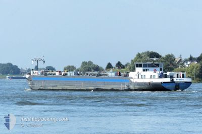
SPECHT
Tanker
Current Trip
| Trip Time | 3 days |
|---|---|
| Trip Distance | 85.34 nm |
| AVG Speed | 4.5 Knots |
| MAX Speed | 5.7 Knots |
| Draught | 1 m |
| AVG Wind | 11.3 knots |
| MAX Wind | 16 knots |
| MIN Temp | -0.7°C / 30.74°F |
| MAX Temp | 12.9°C / 55.22°F |
| Position Received | 5 d ago |
Current Position
| Longitude | --- |
|---|---|
| Latitude | --- |
| Status | Under way using engine |
| Speed | 5.2 Knots |
| Course | 50° |
| Area | North Sea |
| Station | T-AIS |
| Position Received | 5 d ago |
Info
Information
The current position of SPECHT is in North Sea with coordinates 51.67186° / 7.03675° as reported on 2026-03-22 18:57 by AIS to our vessel tracker app. The vessel's current speed is 5.2 Knots and is currently inside the port of MINDEN.
The vessel SPECHT (MMSI: 244650132) is a Tanker It's sailing under the flag of [NL] Netherlands.
In this page you can find informations about the vessels current position, last detected port calls, and current voyage information. If the vessels is not in coverage by AIS you will find the latest position.
The current position of SPECHT is detected by our AIS receivers and we are not responsible for the reliability of the data. The last position was recorded while the vessel was in Coverage by the Ais receivers of our vessel tracking app.
The current draught of SPECHT as reported by AIS is 1 meters
Weather
| Temperature | 3.4°C / 38.12°F |
|---|---|
| Wind Speed | 10 knots |
| Direction | 198° SSW |
| Pressure | 1016.7 hPa |
| Humidity | 79.8 % |
| Cloud Coverage | 100 % |
Featured Company
Last Port Calls
| Port | Arrival | Departure | Time In Port |
|---|---|---|---|
| 2026-03-27 12:41 | |||
| 2026-03-23 17:21 | 2026-03-23 17:59 | 37 m | |
| 2026-03-23 13:13 | 2026-03-23 13:29 | 16 m | |
| 2026-03-22 18:43 | 2026-03-22 19:46 | 1 h | |
| 2026-03-21 22:09 | 2026-03-22 07:12 | 9 h | |
| 2026-03-21 21:13 | 2026-03-21 21:58 | 44 m | |
| 2026-03-20 11:01 | 2026-03-21 00:29 | 13 h | |
| 2026-03-18 17:32 | 2026-03-19 08:47 | 15 h | |
| 2026-03-17 13:18 | 2026-03-17 14:01 | 42 m | |
| 2026-03-14 20:22 | 2026-03-16 07:18 | 1 d |
Last Trips
| Origin | Departure | Destination | Arrival | Distance | |
|---|---|---|---|---|---|
| 2026-03-23 17:59 | 2026-03-27 12:41 | 85.34 nm | |||
| 2026-03-23 13:29 | 2026-03-23 17:21 | 15.10 nm | |||
| 2026-03-22 19:46 | 2026-03-23 13:13 | 37.96 nm | |||
| 2026-03-22 07:12 | 2026-03-22 18:43 | 38.90 nm | |||
| 2026-03-21 21:58 | 2026-03-21 22:09 | 0.95 nm | |||
| 2026-03-21 00:29 | 2026-03-21 21:13 | 94.92 nm | |||
| 2026-03-19 08:47 | 2026-03-20 11:01 | 59.46 nm | |||
| 2026-03-17 14:01 | 2026-03-18 17:32 | 116.70 nm | |||
| 2026-03-14 12:15 | 2026-03-14 20:22 | 32.94 nm | |||
| 2026-03-13 04:33 | 2026-03-14 11:38 | 117.75 nm |
Events
| Time | Event | Details | Position / Dest | Info |
|---|---|---|---|---|
| 2026-03-27 11:41 | STOP Moving |
52.30188 / 8.92160
[DE] MINDEN
|
Speed: Course: 86° |
|
| 2026-03-27 11:41 | PORT ARRIVAL |
|
52.30188 / 8.92160
[DE] MINDEN
|
Speed: 1.8 kn Course: 97° |
| 2026-03-26 17:12 | STOP Moving | --- |
52.34465 / 8.52268
ANTWERPEN HANSADOK
|
Speed: Course: 87° |
| 2026-03-26 09:05 | START Moving | --- |
52.27722 / 7.59656
ANTWERPEN HANSADOK
|
Speed: 3.8 kn Course: 96° |
| 2026-03-26 08:41 | STOP Moving | --- |
52.27772 / 7.58905
ANTWERPEN HANSADOK
|
Speed: 0.1 kn Course: 102° |
| 2026-03-26 08:09 | START Moving | --- |
52.28159 / 7.54983
ANTWERPEN HANSADOK
|
Speed: 4.3 kn Course: 110° |
| 2026-03-26 07:45 | STOP Moving | --- |
52.28265 / 7.54405
ANTWERPEN HANSADOK
|
Speed: 0.3 kn Course: 110° |
| 2026-03-26 06:57 | START Moving | --- |
52.30216 / 7.48150
ANTWERPEN HANSADOK
|
Speed: 3.8 kn Course: 122° |
| 2026-03-26 06:41 | STOP Moving | --- |
52.30568 / 7.47521
ANTWERPEN HANSADOK
|
Speed: 0.1 kn Course: 138° |
| 2026-03-26 05:29 | START Moving | --- |
52.36558 / 7.41449
ANTWERPEN HANSADOK
|
Speed: 3.7 kn Course: 154° |