
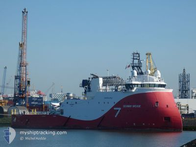
SEAWAY MOXIE
Offshore Supply Ship
Current Trip
| Time Travelled | 8 days |
|---|---|
| Remaining Time | 15 days |
| Distance Travelled | 74.14 nm |
| Remaining Distance | 5593.73 nm |
| AVG Speed | 9.9 Knots |
| MAX Speed | 10.5 Knots |
| AVG Wind | 9.6 knots |
| MAX Wind | 14.2 knots |
| MIN Temp | 15.6°C / 60.08°F |
| MAX Temp | 20.8°C / 69.44°F |
| Draught | 6.1 m |
| Position Received | 8 d ago |
Current Position
| Longitude | 18.70622° |
|---|---|
| Latitude | -34.67707° |
| Status | Under way using engine |
| Speed | 9.8 Knots |
| Course | 115.8° |
| Area | South Atlantic Ocean |
| Station | T-AIS |
| Position Received | 8 d ago |
Info
Information
The current position of SEAWAY MOXIE is in South Atlantic Ocean with coordinates -34.67707° / 18.70622° as reported on 2024-04-18 20:44 by AIS to our vessel tracker app. The vessel's current speed is 9.8 Knots and is heading at the port of SINGAPORE. The estimated time of arrival as calculated by MyShipTracking vessel tracking app is 2024-05-12 02:26 LT
The vessel SEAWAY MOXIE (IMO: 9676216, MMSI: 232015469) is a Offshore Supply Ship that was built in 2014 ( 10 years old ). It's sailing under the flag of [GB] United Kingdom.
In this page you can find informations about the vessels current position, last detected port calls, and current voyage information. If the vessels is not in coverage by AIS you will find the latest position.
The current position of SEAWAY MOXIE is detected by our AIS receivers and we are not responsible for the reliability of the data. The last position was recorded while the vessel was in Coverage by the Ais receivers of our vessel tracking app.
The current draught of SEAWAY MOXIE as reported by AIS is 6.1 meters
Weather
| Temperature | 17.6°C / 63.68°F |
|---|---|
| Wind Speed | 13 knots |
| Direction | 117° ESE |
| Pressure | 1019.7 hPa |
| Humidity | 87.6 % |
| Cloud Coverage | 95 % |
Featured Company
Last Port Calls
| Port | Arrival | Departure | Time In Port |
|---|---|---|---|
| 2024-04-17 14:34 | 2024-04-18 13:17 | 22 h | |
| 2024-03-29 08:02 | 2024-03-29 15:17 | 7 h | |
| 2024-02-22 21:26 | 2024-03-17 05:25 | 23 d | |
| 2024-02-21 05:46 |
Most Visited Ports (Last year)
| Port | Arrivals | |
|---|---|---|
| 7 | ||
| 1 | ||
| 1 | ||
| 1 | ||
| 1 | ||
| 1 |
Last Trips
| Origin | Departure | Destination | Arrival | Distance | |
|---|---|---|---|---|---|
| 2024-03-29 15:17 | 2024-04-17 16:34 | 4187.14 nm | |||
| 2024-03-17 06:25 | 2024-03-29 08:02 | 2258.57 nm | |||
| 2024-02-21 06:46 | 2024-02-22 22:26 | 289.94 nm |
Events
| Time | Event | Details | Position / Dest | Info |
|---|---|---|---|---|
| 2024-04-18 20:44 | OUT of Coverage |
-34.67707 / 18.70622
South Atlantic Ocean
SINGAPORE
|
Speed: 9.8 kn Course: 115.8° |
|
| 2024-04-18 13:25 | Status Changed | Under way using engine Moored |
-33.87806 / 18.43003
SINGAPORE
|
Speed: 9.6 kn Course: 321.3° |
| 2024-04-18 13:17 | PORT DEPARTURE |
|
-33.89737 / 18.43743
SINGAPORE
|
Speed: 8.9 kn Course: 347° |
| 2024-04-18 13:10 | START Moving |
-33.90977 / 18.43471
[ZA] CAPE TOWN
|
Speed: 4 kn Course: 333° |
|
| 2024-04-18 12:41 | Destination Changed | SINGAPORE CAPE TOWN |
-33.91049 / 18.43695
[ZA] CAPE TOWN
|
Speed: Course: 131° |
| 2024-04-18 12:41 | ETA Changed | 2024/05/15 10:00 2024/04/17 08:00 |
-33.91049 / 18.43695
[ZA] CAPE TOWN
|
Speed: Course: 131° |
| 2024-04-17 14:59 | Status Changed | Moored Under way using engine |
-33.91055 / 18.43692
[ZA] CAPE TOWN
|
Speed: Course: 132° |
| 2024-04-17 14:49 | STOP Moving |
-33.91068 / 18.43670
[ZA] CAPE TOWN
|
Speed: 0.3 kn Course: 114° |
|
| 2024-04-17 14:34 | PORT ARRIVAL |
|
-33.90004 / 18.43843
[ZA] CAPE TOWN
|
Speed: 3.5 kn Course: 199° |
| 2024-04-17 14:30 | START Moving | 0.81 nm, North of CAPE TOWN |
-33.89630 / 18.43954
CAPE TOWN
|
Speed: 3.1 kn Course: 200° |