

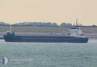
SEA MELODY
General Cargo

Current Trip
| Time Travelled | 12 h, 28 mins |
|---|---|
| Remaining Time | 2 days |
| Distance Travelled | 65.19 nm |
| Remaining Distance | 424.37 nm |
| AVG Speed | 6.8 Knots |
| MAX Speed | 11.2 Knots |
| AVG Wind | 21.4 knots |
| MAX Wind | 27.4 knots |
| MIN Temp | 1.2°C / 34.16°F |
| MAX Temp | 5.5°C / 41.9°F |
| Draught | 3.5 m |
| Position Received | 4 h, 11 m ago |
Current Position
| Longitude | --- |
|---|---|
| Latitude | --- |
| Status | Under way using engine |
| Speed | 4.8 Knots |
| Course | 118° |
| Area | North Sea |
| Station | T-AIS |
| Position Received | 4 h, 11 m ago |
Information
The current position of SEA MELODY is in North Sea with coordinates 55.89968° / -1.35435° as reported on 2025-02-19 06:59 by AIS to our vessel tracker app. The vessel's current speed is 4.8 Knots and is heading at the port of HAMBURG. The estimated time of arrival as calculated by MyShipTracking vessel tracking app is 2025-02-22 09:11 LT
The vessel SEA MELODY (IMO: 9195638, MMSI: 314557000) is a General Cargo that was built in 2002 ( 23 years old ). It's sailing under the flag of [BB] Barbados.
In this page you can find informations about the vessels current position, last detected port calls, and current voyage information. If the vessels is not in coverage by AIS you will find the latest position.
The current position of SEA MELODY is detected by our AIS receivers and we are not responsible for the reliability of the data. The last position was recorded while the vessel was in Coverage by the Ais receivers of our vessel tracking app.
The current draught of SEA MELODY as reported by AIS is 3.5 meters
Weather
| Temperature | 5.5°C / 41.9°F |
|---|---|
| Wind Speed | 27 knots |
| Direction | 153° SSE |
| Pressure | 1015.2 hPa |
| Humidity | 78.5 % |
| Cloud Coverage | 100 % |


Featured Company
Last Port Calls
| Port | Arrival | Departure | Time In Port |
|---|---|---|---|
| 2025-02-15 09:48 | 2025-02-18 22:43 | 3 d | |
| 2025-02-08 21:05 | 2025-02-12 13:04 | 3 d | |
| 2025-02-06 20:43 | |||
| 2025-02-06 20:15 | |||
| 2025-02-06 20:15 | |||
| 2025-02-05 18:24 | |||
| 2025-02-05 17:29 | 2025-02-05 17:59 | 30 m | |
| 2025-02-02 15:44 | 2025-02-04 14:19 | 1 d | |
| 2025-02-01 02:56 | 2025-02-02 15:12 | 1 d | |
| 2025-01-26 20:37 | 2025-01-27 21:33 | 1 d |
Most Visited Ports (Last year)
| Port | Arrivals | |
|---|---|---|
| 10 | ||
| 6 | ||
| 6 | ||
| 5 | ||
| 4 | ||
| 4 |
Last Trips
| Origin | Departure | Destination | Arrival | Distance | |
|---|---|---|---|---|---|
| 2025-02-12 13:04 | 2025-02-15 09:48 | 584.53 nm | |||
| 2025-02-06 20:43 | 2025-02-08 21:05 | 465.57 nm | |||
| 2025-02-05 17:59 | 2025-02-06 20:15 | 3.96 nm | |||
| 2025-02-05 17:59 | 2025-02-05 18:24 | 1.24 nm | |||
| 2025-02-04 14:19 | 2025-02-05 17:29 | 269.22 nm | |||
| 2025-02-02 15:12 | 2025-02-02 15:44 | 3.37 nm | |||
| 2025-01-27 21:33 | 2025-02-01 02:56 | 551.23 nm | |||
| 2025-01-26 20:06 | 2025-01-26 20:37 | 3.10 nm | |||
| 2025-01-21 16:38 | 2025-01-24 17:05 | 779.54 nm | |||
| 2025-01-17 21:11 | 2025-01-20 07:03 | 537.63 nm |
Events
| Time | Event | Details | Position / Dest | Info |
|---|---|---|---|---|
| 2025-02-19 07:08 | Status Changed | Default Under way using engine |
55.89736 / -1.33339
DEHAM
|
Speed: 4.8 kn Course: 118° |
| 2025-02-19 06:59 | OUT of Coverage |
55.89968 / -1.35435
North Sea
DEHAM
|
Speed: 4.8 kn Course: 107.2° |
|
| 2025-02-19 02:52 | Status Changed | Under way using engine Default |
56.01939 / -2.12844
DEHAM
|
Speed: 6.6 kn Course: 115° |
| 2025-02-19 02:48 | Status Changed | Default Under way using engine |
56.02294 / -2.14222
DEHAM
|
Speed: 8 kn Course: 115.5° |
| 2025-02-19 02:39 | Status Changed | Under way using engine Default |
56.03070 / -2.17238
DEHAM
|
Speed: 8 kn Course: 107° |
| 2025-02-19 02:29 | IN Coverage |
56.03070 / -2.17238
North Sea
DEHAM
|
Speed: 8.2 kn Course: 109.1° |
|
| 2025-02-19 00:05 | Status Changed | Default Under way using engine |
56.09454 / -2.81363
DEHAM
|
Speed: 10.9 kn Course: 88.5° |
| 2025-02-19 00:04 | OUT of Coverage |
56.09438 / -2.82341
North Sea
DEHAM
|
Speed: 10.9 kn Course: 88.5° |
|
| 2025-02-18 22:43 | PORT DEPARTURE |
|
55.99217 / -3.18589
DEHAM
|
Speed: 5.6 kn Course: 330° |
| 2025-02-18 22:41 | START Moving |
55.98950 / -3.18181
[GB] LEITH
|
Speed: 4.3 kn Course: 320° |