
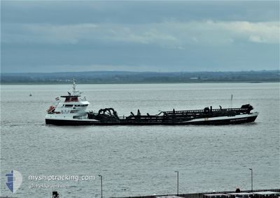
SCELVERINGHE
Trailing Suction Hopper Dredger
Current Trip
DREDGE AREA
| Time Travelled | 3 h, 10 mins |
|---|---|
| Remaining Time | --- |
| Distance Travelled | 22.03 nm |
| Remaining Distance | --- |
| AVG Speed | 7.4 Knots |
| MAX Speed | 10.3 Knots |
| AVG Wind | 23.8 knots |
| MAX Wind | 27.1 knots |
| MIN Temp | 8.7°C / 47.66°F |
| MAX Temp | 9.5°C / 49.1°F |
| Draught | 6.3 m |
| Position Received | 1 m ago |
Current Position
| Longitude | --- |
|---|---|
| Latitude | --- |
| Status | Under way using engine |
| Speed | 8.1 Knots |
| Course | 329° |
| Area | North Sea |
| Station | T-AIS |
| Position Received | 1 m ago |
Info
Information
The current position of SCELVERINGHE is in North Sea with coordinates 51.64237° / 2.74281° as reported on 2024-11-27 22:04 by AIS to our vessel tracker app. The vessel's current speed is 8.1 Knots
The vessel SCELVERINGHE (IMO: 9285366, MMSI: 244476000) is a Trailing Suction Hopper Dredger that was built in 2004 ( 20 years old ). It's sailing under the flag of [NL] Netherlands.
In this page you can find informations about the vessels current position, last detected port calls, and current voyage information. If the vessels is not in coverage by AIS you will find the latest position.
The current position of SCELVERINGHE is detected by our AIS receivers and we are not responsible for the reliability of the data. The last position was recorded while the vessel was in Coverage by the Ais receivers of our vessel tracking app.
The current draught of SCELVERINGHE as reported by AIS is 6.3 meters
Weather
| Temperature | 9.6°C / 49.28°F |
|---|---|
| Wind Speed | 21 knots |
| Direction | 316° NW |
| Pressure | 1018.5 hPa |
| Humidity | 68.8 % |
| Cloud Coverage | 100 % |
Featured Company
Last Port Calls
| Port | Arrival | Departure | Time In Port |
|---|---|---|---|
| 2024-11-27 13:24 | 2024-11-27 19:56 | 6 h | |
| 2024-11-26 23:19 | 2024-11-27 08:09 | 8 h | |
| 2024-11-25 14:10 | 2024-11-25 14:40 | 29 m | |
| 2024-11-25 10:49 | 2024-11-25 14:07 | 3 h | |
| 2024-11-25 09:41 | 2024-11-25 10:22 | 40 m | |
| 2024-11-22 18:37 | 2024-11-22 19:22 | 45 m | |
| 2024-11-22 07:01 | 2024-11-22 16:54 | 9 h | |
| 2024-11-20 16:26 | 2024-11-20 20:45 | 4 h | |
| 2024-11-13 10:01 | 2024-11-19 00:01 | 5 d | |
| 2024-11-12 02:45 | 2024-11-12 07:17 | 4 h |
Last Trips
| Origin | Departure | Destination | Arrival | Distance | |
|---|---|---|---|---|---|
| 2024-11-27 08:09 | 2024-11-27 13:24 | 36.65 nm | |||
| 2024-11-25 14:40 | 2024-11-26 23:19 | 270.79 nm | |||
| 2024-11-25 14:07 | 2024-11-25 14:10 | 0.32 nm | |||
| 2024-11-25 10:22 | 2024-11-25 10:49 | 1.62 nm | |||
| 2024-11-22 19:22 | 2024-11-25 09:41 | 301.95 nm | |||
| 2024-11-22 16:54 | 2024-11-22 18:37 | 13.06 nm | |||
| 2024-11-20 20:45 | 2024-11-22 07:01 | 312.96 nm | |||
| 2024-11-19 00:01 | 2024-11-20 16:26 | 271.08 nm | |||
| 2024-11-12 07:17 | 2024-11-13 10:01 | 204.22 nm | |||
| 2024-11-09 01:36 | 2024-11-12 02:45 | 328.27 nm |
Events
| Time | Event | Details | Position / Dest | Info |
|---|---|---|---|---|
| 2024-11-27 18:56 | PORT DEPARTURE |
|
51.36574 / 3.18878
DREDGE AREA
|
Speed: 10.3 kn Course: 314° |
| 2024-11-27 18:43 | START Moving |
51.33542 / 3.21597
[BE] ZEEBRUGGE
|
Speed: 4.4 kn Course: 330° |
|
| 2024-11-27 18:12 | STOP Moving |
51.33381 / 3.21748
[BE] ZEEBRUGGE
|
Speed: 0.3 kn Course: 331° |
|
| 2024-11-27 17:42 | START Moving |
51.32231 / 3.19931
[BE] ZEEBRUGGE
|
Speed: 4.5 kn Course: 169° |
|
| 2024-11-27 17:40 | STOP Moving |
51.32422 / 3.19882
[BE] ZEEBRUGGE
|
Speed: Course: 182° |
|
| 2024-11-27 17:37 | ETA Changed | 2024/11/28 10:30 2024/11/27 09:30 |
51.32295 / 3.19613
[BE] ZEEBRUGGE
|
Speed: 3.2 kn Course: 244° |
| 2024-11-27 17:36 | START Moving |
51.32289 / 3.19594
[BE] ZEEBRUGGE
|
Speed: 3.1 kn Course: 243° |
|
| 2024-11-27 14:43 | STOP Moving |
51.32193 / 3.19315
[BE] ZEEBRUGGE
|
Speed: 0.3 kn Course: 238° |
|
| 2024-11-27 14:05 | START Moving |
51.33324 / 3.21767
[BE] ZEEBRUGGE
|
Speed: 3.2 kn Course: 150° |
|
| 2024-11-27 12:38 | STOP Moving |
51.34196 / 3.20666
[BE] ZEEBRUGGE
|
Speed: 0.2 kn Course: 149° |