

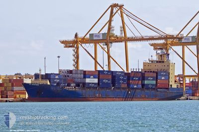
SC MEDFORD
Container Ship

Current Trip
| Time Travelled | 2 days |
|---|---|
| Remaining Time | --- |
| Distance Travelled | 839.31 nm |
| Remaining Distance | --- |
| AVG Speed | 13.6 Knots |
| MAX Speed | 16.3 Knots |
| AVG Wind | 11 knots |
| MAX Wind | 17.9 knots |
| MIN Temp | 4.9°C / 40.82°F |
| MAX Temp | 15.5°C / 59.9°F |
| Draught | 7.8 m |
| Position Received | 1 m ago |
Current Position
| Longitude | --- |
|---|---|
| Latitude | --- |
| Status | Under way using engine |
| Speed | 1.2 Knots |
| Course | 168° |
| Area | Aegean Sea |
| Station | T-AIS |
| Position Received | 1 m ago |
Information
The current position of SC MEDFORD is in Aegean Sea with coordinates 37.64335° / 23.55442° as reported on 2025-02-19 04:05 by AIS to our vessel tracker app. The vessel's current speed is 1.2 Knots
The vessel SC MEDFORD (IMO: 9275103, MMSI: 636020667) is a Container Ship that was built in 2004 ( 21 years old ). It's sailing under the flag of [LR] Liberia.
In this page you can find informations about the vessels current position, last detected port calls, and current voyage information. If the vessels is not in coverage by AIS you will find the latest position.
The current position of SC MEDFORD is detected by our AIS receivers and we are not responsible for the reliability of the data. The last position was recorded while the vessel was in Coverage by the Ais receivers of our vessel tracking app.
The current draught of SC MEDFORD as reported by AIS is 7.8 meters
Weather
| Temperature | 10.5°C / 50.9°F |
|---|---|
| Wind Speed | 7 knots |
| Direction | 61° ENE |
| Pressure | 1020.2 hPa |
| Humidity | 79.5 % |
| Cloud Coverage | 100 % |


Featured Company
Last Port Calls
| Port | Arrival | Departure | Time In Port |
|---|---|---|---|
| 2025-02-15 16:37 | 2025-02-16 12:49 | 20 h | |
| 2025-02-13 21:53 | 2025-02-14 09:41 | 11 h | |
| 2025-02-08 06:08 | 2025-02-09 20:32 | 1 d | |
| 2025-02-01 22:53 | 2025-02-03 17:57 | 1 d | |
| 2025-01-28 08:24 | 2025-01-29 09:41 | 1 d | |
| 2025-01-21 20:00 | 2025-01-22 13:45 | 17 h | |
| 2025-01-20 20:18 | 2025-01-21 13:16 | 16 h | |
| 2025-01-15 06:48 | 2025-01-16 04:17 | 21 h | |
| 2025-01-10 12:42 | 2025-01-11 13:49 | 1 d | |
| 2025-01-09 01:43 | 2025-01-09 19:34 | 17 h |
Last Trips
| Origin | Departure | Destination | Arrival | Distance | |
|---|---|---|---|---|---|
| 2025-02-14 10:41 | 2025-02-15 17:37 | 13.44 nm | |||
| 2025-02-09 22:32 | 2025-02-13 22:53 | 845.75 nm | |||
| 2025-02-03 18:57 | 2025-02-08 08:08 | 852.63 nm | |||
| 2025-01-29 11:41 | 2025-02-01 23:53 | 861.15 nm | |||
| 2025-01-22 15:45 | 2025-01-28 10:24 | 668.55 nm | |||
| 2025-01-21 15:16 | 2025-01-21 22:00 | 81.83 nm | |||
| 2025-01-16 05:17 | 2025-01-20 22:18 | 1199.31 nm | |||
| 2025-01-11 14:49 | 2025-01-15 07:48 | 569.25 nm | |||
| 2025-01-09 20:34 | 2025-01-10 13:42 | 246.66 nm | |||
| 2025-01-04 01:56 | 2025-01-09 02:43 | 1676.25 nm |
Events
| Time | Event | Details | Position / Dest | Info |
|---|---|---|---|---|
| 2025-02-19 04:06 | ETA Changed | 2026/01/01 20:00 2025/02/18 20:00 |
37.64342 / 23.55413
GRPIR
|
Speed: 1.1 kn Course: 167° |
| 2025-02-18 22:36 | ETA Changed | 2025/02/18 20:00 2026/01/01 20:00 |
37.61117 / 23.59299
GRPIR
|
Speed: 1 kn Course: 145° |
| 2025-02-18 22:30 | ETA Changed | 2026/01/01 20:00 2025/02/18 20:00 |
37.61131 / 23.59513
GRPIR
|
Speed: 1.1 kn Course: 145° |
| 2025-02-18 22:24 | ETA Changed | 2025/02/18 20:00 2026/01/01 20:00 |
37.61144 / 23.59740
GRPIR
|
Speed: 1.1 kn Course: 145° |
| 2025-02-18 22:18 | ETA Changed | 2026/01/01 20:00 2025/02/18 20:00 |
37.61162 / 23.59963
GRPIR
|
Speed: 1 kn Course: 145° |
| 2025-02-18 16:18 | Status Changed | Under way using engine Default |
37.23474 / 23.55577
GRPIR
|
Speed: 15.3 kn Course: 21° |
| 2025-02-18 16:02 | Status Changed | Default Under way using engine |
37.17508 / 23.52061
GRPIR
|
Speed: 15.4 kn Course: 19.1° |
| 2025-02-18 15:08 | Status Changed | Under way using engine Default |
36.96773 / 23.40209
GRPIR
|
Speed: 15 kn Course: 22° |
| 2025-02-18 14:50 | Status Changed | Default Under way using engine |
36.89748 / 23.37412
GRPIR
|
Speed: 15.4 kn Course: 11.5° |
| 2025-02-18 14:39 | Change Sea Area | Greek part of the Aegean Sea Greek part of the Ionian Sea |
36.85117 / 23.36256
Aegean Sea
GRPIR
|
Speed: 15.3 kn Course: 12.5° |