
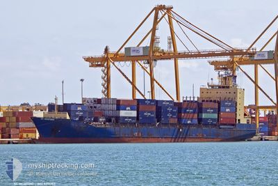
SC MEDFORD
Container Ship
Current Trip
| Time Travelled | 12 days |
|---|---|
| Remaining Time | 20 mins |
| Distance Travelled | 1852.96 nm |
| Remaining Distance | 3.62 nm |
| AVG Speed | 8.3 Noeuds |
| MAX Speed | 16.7 Noeuds |
| AVG Wind | 8.3 knots |
| MAX Wind | 21 knots |
| MIN Temp | 17.1°C / 62.78°F |
| MAX Temp | 31.2°C / 88.16°F |
| Tirant d eau | 7.3 m |
| Position reçue | Maintenant |
Current Position
| Longitude | 23.57140° |
|---|---|
| Latitude | 37.90695° |
| Etat | Under way using engine |
| Vitesse | 0.2 Noeuds |
| Parcours | 10° |
| Zone | Aegean Sea |
| Station | T-AIS |
| Position reçue | Maintenant |
Info
Information
The current position of SC MEDFORD is in Aegean Sea with coordinates 37.90695° / 23.57140° as reported on 2024-06-07 20:12 by AIS to our vessel tracker app. The vessel's current speed is 0.2 Noeuds and is heading at the port of PIRAEUS. The estimated time of arrival as calculated by MyShipTracking vessel tracking app is 2024-06-07 23:32 LT
The vessel SC MEDFORD (IMO: 9275103, MMSI: 636020667) is a Container Ship that was built in 2004 ( 20 Age ). It's sailing under the flag of [LR] Liberia.
In this page you can find informations about the vessels current position, last detected port calls, and current voyage information. If the vessels is not in coverage by AIS you will find the latest position.
The current position of SC MEDFORD is detected by our AIS receivers and we are not responsible for the reliability of the data. The last position was recorded while the vessel was in Coverage by the Ais receivers of our vessel tracking app.
The current draught of SC MEDFORD as reported by AIS is 7.3 meters
Weather
| Temperature | 25.8°C / 78.44°F |
|---|---|
| Wind Speed | 8 knots |
| Direction | 357° N |
| Pressure | 1012.8 hPa |
| Humidity | 47.6 % |
| Cloud Coverage | --- |
Featured Company
Last Port Calls
| Port | Arrival | Departure | Time In Port |
|---|---|---|---|
| 2024-05-24 04:44 | 2024-05-26 11:04 | 2 d | |
| 2024-05-16 20:45 | 2024-05-17 12:50 | 16 h | |
| 2024-05-14 05:40 | 2024-05-15 02:50 | 21 h | |
| 2024-05-09 03:06 | 2024-05-09 19:09 | 16 h | |
| 2024-05-07 23:03 | 2024-05-08 20:02 | 20 h | |
| 2024-05-02 04:40 | 2024-05-04 04:32 | 1 d | |
| 2024-04-24 10:24 | 2024-04-24 21:38 | 11 h | |
| 2024-04-20 08:13 | 2024-04-20 17:24 | 9 h | |
| 2024-04-18 18:35 | 2024-04-19 12:40 | 18 h | |
| 2024-04-17 15:14 | 2024-04-18 01:05 | 9 h |
Most Visited Ports (Last year)
| Port | Arrivals | |
|---|---|---|
| 9 | ||
| 9 | ||
| 8 | ||
| 8 | ||
| 8 | ||
| 8 |
Last Trips
| Origin | Departure | Destination | Arrival | Distance | |
|---|---|---|---|---|---|
| 2024-05-17 12:50 | 2024-05-24 04:44 | 1733.95 nm | |||
| 2024-05-15 02:50 | 2024-05-16 20:45 | 546.67 nm | |||
| 2024-05-09 19:09 | 2024-05-14 05:40 | 923.34 nm | |||
| 2024-05-08 20:02 | 2024-05-09 03:06 | 70.91 nm | |||
| 2024-05-04 04:32 | 2024-05-07 23:03 | 1097.91 nm | |||
| 2024-04-24 21:38 | 2024-05-02 04:40 | 633.84 nm | |||
| 2024-04-20 17:24 | 2024-04-24 10:24 | 1089.53 nm | |||
| 2024-04-19 12:40 | 2024-04-20 08:13 | 156.11 nm | |||
| 2024-04-18 01:05 | 2024-04-18 18:35 | 203.92 nm | |||
| 2024-04-17 03:37 | 2024-04-17 15:14 | 215.53 nm |
Events
| Heure | Evenement | Détails | Position/ Destination | Info |
|---|---|---|---|---|
| 2024-06-07 20:09 | Arret | 2.31 nm, South of PSYTTALEIA |
37.90691 / 23.57114
GRPIR
|
Vitesse: 0.3 kn Parcours: 19° |
| 2024-06-07 19:46 | Démarrage | 2.96 nm, East of PERANI |
37.89679 / 23.54579
GRPIR
|
Vitesse: 5.3 kn Parcours: 88.8° |
| 2024-06-07 19:41 | Etat Changé | Under way using engine At anchor |
37.89781 / 23.54205
GRPIR
|
Vitesse: 0.3 kn Parcours: 108° |
| 2024-06-07 17:09 | Changement d'ETA | 2024/06/07 22:00 2024/06/06 06:00 |
37.89977 / 23.54572
GRPIR
|
Vitesse: Parcours: 240° |
| 2024-06-07 02:08 | Changement d'ETA | 2024/06/06 06:00 2025/01/01 06:00 |
37.89826 / 23.54482
GRPIR
|
Vitesse: Parcours: 4° |
| 2024-06-07 02:02 | Changement d'ETA | 2025/01/01 06:00 2024/06/06 06:00 |
37.89827 / 23.54484
GRPIR
|
Vitesse: Parcours: 3° |
| 2024-06-06 05:18 | Arret | 2.88 nm, East of PERANI |
37.89807 / 23.54397
GRPIR
|
Vitesse: 0.2 kn Parcours: 15° |
| 2024-06-06 05:15 | Etat Changé | At anchor Under way using engine |
37.89789 / 23.54419
GRPIR
|
Vitesse: 0.5 kn Parcours: 12° |
| 2024-06-05 15:00 | Démarrage | 20.46 nm, East of AVLEMONAS |
36.27649 / 23.49896
GRPIR
|
Vitesse: 3.2 kn Parcours: 115° |
| 2024-06-05 13:14 | Arret | 20.19 nm, East of AVLEMONAS |
36.27473 / 23.49375
GRPIR
|
Vitesse: 0.3 kn Parcours: 136° |