
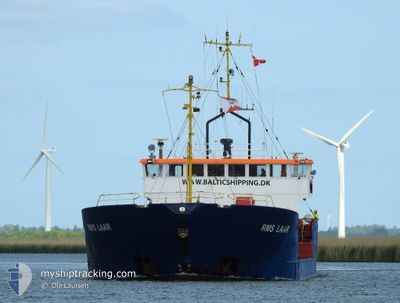
RMS LAAR
General Cargo
Current Trip
| Time Travelled | 4 days |
|---|---|
| Remaining Time | 12 h, 21 mins |
| Distance Travelled | 334.21 nm |
| Remaining Distance | 122.11 nm |
| AVG Speed | 9.1 Knots |
| MAX Speed | 11.7 Knots |
| AVG Wind | 7.6 knots |
| MAX Wind | 16.3 knots |
| MIN Temp | 0.2°C / 32.36°F |
| MAX Temp | 5.9°C / 42.62°F |
| Draught | 2.8 m |
| Position Received | 1 m ago |
Current Position
| Longitude | --- |
|---|---|
| Latitude | --- |
| Status | Under way using engine |
| Speed | 9.6 Knots |
| Course | 121.6° |
| Area | Kattegat |
| Station | T-AIS |
| Position Received | 1 m ago |
Info
Information
The current position of RMS LAAR is in Kattegat with coordinates 56.74537° / 10.91151° as reported on 2025-03-17 17:41 by AIS to our vessel tracker app. The vessel's current speed is 9.6 Knots and is heading at the port of KOEGE. The estimated time of arrival as calculated by MyShipTracking vessel tracking app is 2025-03-18 07:03 LT
The vessel RMS LAAR (IMO: 8508400, MMSI: 636018261) is a General Cargo that was built in 1985 ( 40 years old ). It's sailing under the flag of [LR] Liberia.
In this page you can find informations about the vessels current position, last detected port calls, and current voyage information. If the vessels is not in coverage by AIS you will find the latest position.
The current position of RMS LAAR is detected by our AIS receivers and we are not responsible for the reliability of the data. The last position was recorded while the vessel was in Coverage by the Ais receivers of our vessel tracking app.
The current draught of RMS LAAR as reported by AIS is 2.8 meters
Weather
| Temperature | 4.2°C / 39.56°F |
|---|---|
| Wind Speed | 16 knots |
| Direction | 278° W |
| Pressure | 1029.8 hPa |
| Humidity | 66.6 % |
| Cloud Coverage | 1 % |
Featured Company
Last Port Calls
| Port | Arrival | Departure | Time In Port |
|---|---|---|---|
| 2025-03-12 06:02 | 2025-03-13 05:25 | 23 h | |
| 2025-03-08 18:03 | 2025-03-10 04:51 | 1 d | |
| 2025-03-07 03:24 | 2025-03-07 18:26 | 15 h | |
| 2025-03-04 20:12 | 2025-03-06 13:50 | 1 d | |
| 2025-03-01 06:48 | 2025-03-03 09:41 | 2 d | |
| 2025-02-27 23:42 | 2025-02-28 15:05 | 15 h | |
| 2025-02-25 09:43 | 2025-02-26 05:30 | 19 h | |
| 2025-02-17 01:08 | 2025-02-18 14:50 | 1 d | |
| 2025-02-12 16:33 | 2025-02-14 13:49 | 1 d | |
| 2025-02-10 12:47 | 2025-02-11 10:59 | 22 h |
Last Trips
| Origin | Departure | Destination | Arrival | Distance | |
|---|---|---|---|---|---|
| 2025-03-10 04:51 | 2025-03-12 06:02 | 122.27 nm | |||
| 2025-03-07 18:26 | 2025-03-08 18:03 | 209.77 nm | |||
| 2025-03-06 13:50 | 2025-03-07 03:24 | 127.76 nm | |||
| 2025-03-03 09:41 | 2025-03-04 20:12 | 176.86 nm | |||
| 2025-02-28 15:05 | 2025-03-01 06:48 | 117.77 nm | |||
| 2025-02-26 05:30 | 2025-02-27 23:42 | 387.27 nm | |||
| 2025-02-18 14:50 | 2025-02-25 09:43 | 630.31 nm | |||
| 2025-02-14 13:49 | 2025-02-17 01:08 | 186.41 nm | |||
| 2025-02-11 10:59 | 2025-02-12 16:33 | 222.94 nm | |||
| 2025-02-09 08:10 | 2025-02-10 12:47 | 185.18 nm |
Events
| Time | Event | Details | Position / Dest | Info |
|---|---|---|---|---|
| 2025-03-17 14:18 | START Moving | 3.34 nm, East of AALBORG |
57.05025 / 10.06053
DKKOG
|
Speed: 6.5 kn Course: 45.4° |
| 2025-03-17 14:08 | Status Changed | Under way using engine Moored |
57.04839 / 10.05758
DKKOG
|
Speed: Course: 58° |
| 2025-03-17 13:56 | Draught Changed | 2.8 3.9 |
57.04840 / 10.05755
DKKOG
|
Speed: Course: 60° |
| 2025-03-17 13:56 | Destination Changed | DKKOG DKAAL |
57.04840 / 10.05755
DKKOG
|
Speed: Course: 60° |
| 2025-03-17 13:56 | ETA Changed | 2025/03/18 10:00 2025/03/14 16:00 |
57.04840 / 10.05755
DKKOG
|
Speed: Course: 60° |
| 2025-03-17 13:04 | Status Changed | Moored Default |
57.04837 / 10.05758
DKAAL
|
Speed: Course: 60° |
| 2025-03-17 13:01 | Status Changed | Default Moored |
57.04838 / 10.05748
DKAAL
|
Speed: Course: 60° |
| 2025-03-14 13:55 | Status Changed | Moored Under way using engine |
57.04839 / 10.05753
DKAAL
|
Speed: Course: 59° |
| 2025-03-14 13:36 | STOP Moving | 3.27 nm, East of AALBORG |
57.04908 / 10.05791
DKAAL
|
Speed: 0.3 kn Course: 320° |
| 2025-03-14 02:19 | Change Sea Area | Danish part of the Kattegat Swedish part of the Kattegat |
56.21163 / 12.36743
Kattegat
DKAAL
|
Speed: 9.5 kn Course: 295° |