
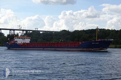
RMS LAAR
General Cargo
Current Trip
| Time Travelled | 2 days |
|---|---|
| Remaining Time | 8 h, 14 mins |
| Distance Travelled | 517.68 nm |
| Remaining Distance | 63.59 nm |
| AVG Speed | 8.1 Noeuds |
| MAX Speed | 9.6 Noeuds |
| AVG Wind | 9.4 knots |
| MAX Wind | 20.8 knots |
| MIN Temp | 5.4°C / 41.72°F |
| MAX Temp | 12.3°C / 54.14°F |
| Tirant d eau | 3.6 m |
| Position reçue | 6 m depuis |
Current Position
| Longitude | 21.20655° |
|---|---|
| Latitude | 59.63705° |
| Etat | At anchor |
| Vitesse | |
| Parcours | 76° |
| Zone | Baltic Sea |
| Station | T-AIS |
| Position reçue | 6 m depuis |
Info
Information
The current position of RMS LAAR is in Baltic Sea with coordinates 59.63705° / 21.20655° as reported on 2024-05-02 05:49 by AIS to our vessel tracker app. The vessel's current speed is 0 Noeuds and is heading at the port of TURKU. The estimated time of arrival as calculated by MyShipTracking vessel tracking app is 2024-05-02 14:09 LT
The vessel RMS LAAR (IMO: 8508400, MMSI: 636018261) is a General Cargo that was built in 1985 ( 39 Age ). It's sailing under the flag of [LR] Liberia.
In this page you can find informations about the vessels current position, last detected port calls, and current voyage information. If the vessels is not in coverage by AIS you will find the latest position.
The current position of RMS LAAR is detected by our AIS receivers and we are not responsible for the reliability of the data. The last position was recorded while the vessel was in Coverage by the Ais receivers of our vessel tracking app.
The current draught of RMS LAAR as reported by AIS is 3.6 meters
Weather
| Temperature | 5.5°C / 41.9°F |
|---|---|
| Wind Speed | 7 knots |
| Direction | 121° ESE |
| Pressure | 1025.5 hPa |
| Humidity | 81 % |
| Cloud Coverage | 78 % |
Featured Company
Last Port Calls
| Port | Arrival | Departure | Time In Port |
|---|---|---|---|
| 2024-04-28 17:12 | 2024-04-29 13:09 | 19 h | |
| 2024-04-27 22:56 | 2024-04-28 09:11 | 10 h | |
| 2024-04-23 10:02 | 2024-04-23 16:30 | 6 h | |
| 2024-04-21 07:14 | 2024-04-22 14:52 | 1 d | |
| 2024-04-18 07:23 | 2024-04-20 10:51 | 2 d | |
| 2024-04-17 01:35 | 2024-04-17 10:43 | 9 h | |
| 2024-04-14 19:09 | 2024-04-15 19:42 | 1 d | |
| 2024-04-13 03:58 | 2024-04-13 19:06 | 15 h | |
| 2024-04-10 16:41 | 2024-04-11 17:27 | 1 d | |
| 2024-04-07 07:26 | 2024-04-10 11:18 | 3 d |
Last Trips
| Origin | Departure | Destination | Arrival | Distance | |
|---|---|---|---|---|---|
| 2024-04-28 11:11 | 2024-04-28 19:12 | 73.22 nm | |||
| 2024-04-23 18:30 | 2024-04-28 00:56 | 512.44 nm | |||
| 2024-04-22 16:52 | 2024-04-23 12:02 | 168.10 nm | |||
| 2024-04-20 12:51 | 2024-04-21 09:14 | 181.44 nm | |||
| 2024-04-17 12:43 | 2024-04-18 09:23 | 156.90 nm | |||
| 2024-04-15 21:42 | 2024-04-17 03:35 | 254.93 nm | |||
| 2024-04-13 21:06 | 2024-04-14 21:09 | 142.03 nm | |||
| 2024-04-11 19:27 | 2024-04-13 05:58 | 288.22 nm | |||
| 2024-04-10 13:18 | 2024-04-10 18:41 | 46.11 nm | |||
| 2024-04-05 16:24 | 2024-04-07 09:26 | 233.81 nm |
Events
| Heure | Evenement | Détails | Position/ Destination | Info |
|---|---|---|---|---|
| 2024-05-02 04:43 | Arret |
59.63717 / 21.20698
FITKU
|
Vitesse: Parcours: 89° |
|
| 2024-05-02 04:34 | Etat Changé | At anchor Under way using engine |
59.63694 / 21.20747
FITKU
|
Vitesse: 0.7 kn Parcours: 47° |
| 2024-05-02 03:27 | Detecté en mer | Finnish part of the Baltic Sea |
59.53059 / 21.07030
Baltic Sea
FITKU
|
Vitesse: 8 kn Parcours: 36.1° |
| 2024-05-02 03:27 | Dans la zone couverte |
59.53059 / 21.07030
Baltic Sea
FITKU
|
Vitesse: 8 kn Parcours: 36.1° |
|
| 2024-05-01 21:10 | Etat Changé | Default Under way using engine |
58.94680 / 19.78342
FITKU
|
Vitesse: 8.7 kn Parcours: 50.3° |
| 2024-05-01 21:09 | Hors de la zone couverte |
58.94498 / 19.77917
Baltic Sea
FITKU
|
Vitesse: 8.7 kn Parcours: 50.3° |
|
| 2024-05-01 14:22 | Etat Changé | Under way using engine Default |
58.24718 / 18.60908
FITKU
|
Vitesse: 8.1 kn Parcours: 22° |
| 2024-05-01 14:00 | Etat Changé | Default Under way using engine |
58.20376 / 18.56929
FITKU
|
Vitesse: 8.5 kn Parcours: 31.8° |
| 2024-05-01 13:54 | Etat Changé | Under way using engine Default |
58.19063 / 18.55439
FITKU
|
Vitesse: 8.5 kn Parcours: 31° |
| 2024-05-01 13:48 | Etat Changé | Default Under way using engine |
58.17916 / 18.54166
FITKU
|
Vitesse: 8.5 kn Parcours: 30.7° |