

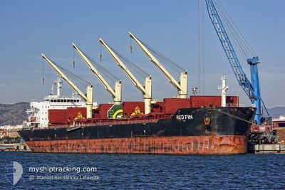
RED FIN
Bulk Carrier

Current Trip
| Time Travelled | 21 days |
|---|---|
| Remaining Time | --- |
| Distance Travelled | 4753.24 nm |
| Remaining Distance | --- |
| AVG Speed | 10.4 Knots |
| MAX Speed | 14.2 Knots |
| AVG Wind | 15 knots |
| MAX Wind | 29 knots |
| MIN Temp | -3.3°C / 26.06°F |
| MAX Temp | 19.2°C / 66.56°F |
| Draught | 12.8 m |
| Position Received | 15 h, 43 m ago |
Current Position
| Longitude | --- |
|---|---|
| Latitude | --- |
| Status | Under way using engine |
| Speed | 9.8 Knots |
| Course | 252.1° |
| Area | Baltic Sea |
| Station | T-AIS |
| Position Received | 15 h, 43 m ago |
Information
The current position of RED FIN is in Baltic Sea with coordinates 59.52240° / 22.70658° as reported on 2025-03-25 09:51 by AIS to our vessel tracker app. The vessel's current speed is 9.8 Knots and is heading at the port of NEW ORLEANS. The estimated time of arrival as calculated by MyShipTracking vessel tracking app is 2025-04-15 19:00 LT
The vessel RED FIN (IMO: 9607306, MMSI: 256610000) is a Bulk Carrier that was built in 2011 ( 14 years old ). It's sailing under the flag of [MT] Malta.
In this page you can find informations about the vessels current position, last detected port calls, and current voyage information. If the vessels is not in coverage by AIS you will find the latest position.
The current position of RED FIN is detected by our AIS receivers and we are not responsible for the reliability of the data. The last position was recorded while the vessel was in Coverage by the Ais receivers of our vessel tracking app.
The current draught of RED FIN as reported by AIS is 12.8 meters
Weather
| Temperature | 5°C / 41°F |
|---|---|
| Wind Speed | 7 knots |
| Direction | 279° W |
| Pressure | 1008.7 hPa |
| Humidity | 94.8 % |
| Cloud Coverage | 100 % |


Featured Company
Most Visited Ports (Last year)
| Port | Arrivals | |
|---|---|---|
| 6 | ||
| 3 | ||
| 1 | ||
| 1 | ||
| 1 | ||
| 1 |
Last Trips
| Origin | Departure | Destination | Arrival | Distance |
|---|
Events
| Time | Event | Details | Position / Dest | Info |
|---|---|---|---|---|
| 2025-03-25 09:57 | Status Changed | Default Under way using engine |
59.51809 / 22.67917
US MSY
|
Speed: 9.8 kn Course: 252.1° |
| 2025-03-25 09:51 | OUT of Coverage |
59.52240 / 22.70658
Baltic Sea
US MSY
|
Speed: 9.8 kn Course: 252.1° |
|
| 2025-03-25 08:37 | Detected in Sea | Finnish part of the Baltic Sea |
59.58362 / 23.08703
Baltic Sea
US MSY
|
Speed: 9.7 kn Course: 253° |
| 2025-03-25 07:55 | IN Coverage |
59.61633 / 23.30168
Gulf of Finland
US MSY
|
Speed: 9.8 kn Course: 253.6° |
|
| 2025-03-25 07:54 | Status Changed | Under way using engine Default |
59.61791 / 23.31206
US MSY
|
Speed: 9.7 kn Course: 253° |
| 2025-03-25 05:20 | Status Changed | Default Under way using engine |
59.73715 / 24.09590
US MSY
|
Speed: 9.6 kn Course: 252.8° |
| 2025-03-25 05:15 | OUT of Coverage |
59.74057 / 24.11801
Gulf of Finland
US MSY
|
Speed: 9.6 kn Course: 252.8° |
|
| 2025-03-25 03:25 | Detected in Sea | Finnish part of the Gulf of Finland |
59.81005 / 24.69129
Gulf of Finland
US MSY
|
Speed: 9.9 kn Course: 257.7° |
| 2025-03-25 01:11 | Detected in Sea | Estonian part of the Gulf of Finland |
59.87827 / 25.41435
Gulf of Finland
US MSY
|
Speed: 10.2 kn Course: 259.7° |
| 2025-03-25 00:35 | Status Changed | Under way using engine Default |
59.89627 / 25.61112
US MSY
|
Speed: 10.1 kn Course: 260° |