
QUADRANS 2
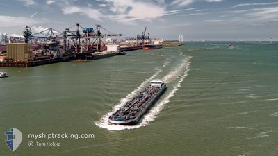
Tanker
Current Trip
| Time Travelled | 10 h, 38 mins |
|---|---|
| Remaining Time | --- |
| Distance Travelled | 39.03 nm |
| Remaining Distance | --- |
| AVG Speed | 9.6 Knots |
| MAX Speed | 11.7 Knots |
| AVG Wind | 6.5 knots |
| MAX Wind | 7.1 knots |
| MIN Temp | -2°C / 28.4°F |
| MAX Temp | 1.7°C / 35.06°F |
| Draught | 3 m |
| Position Received | 21 m ago |
Current Position
| Longitude | --- |
|---|---|
| Latitude | --- |
| Status | Moored |
| Speed | |
| Course | --- |
| Area | North Sea |
| Station | T-AIS |
| Position Received | 21 m ago |
Info
Information
The current position of QUADRANS 2 is in North Sea with coordinates 51.66089° / 4.17981° as reported on 2025-02-18 03:27 by AIS to our vessel tracker app. The vessel's current speed is 0 Knots
The vessel QUADRANS 2 (MMSI: 244650607) is a Tanker It's sailing under the flag of [NL] Netherlands.
In this page you can find informations about the vessels current position, last detected port calls, and current voyage information. If the vessels is not in coverage by AIS you will find the latest position.
The current position of QUADRANS 2 is detected by our AIS receivers and we are not responsible for the reliability of the data. The last position was recorded while the vessel was in Coverage by the Ais receivers of our vessel tracking app.
The current draught of QUADRANS 2 as reported by AIS is 3 meters
Weather
| Temperature | -2.4°C / 27.68°F |
|---|---|
| Wind Speed | 8 knots |
| Direction | 74° ENE |
| Pressure | 1024.5 hPa |
| Humidity | 62.3 % |
| Cloud Coverage | 38 % |
Featured Company
Last Port Calls
| Port | Arrival | Departure | Time In Port |
|---|---|---|---|
| 2025-02-17 13:19 | 2025-02-17 17:10 | 3 h | |
| 2025-02-15 12:31 | 2025-02-17 11:43 | 1 d | |
| 2025-02-15 10:07 | 2025-02-15 10:40 | 32 m | |
| 2025-02-14 22:27 | 2025-02-15 07:40 | 9 h | |
| 2025-02-13 13:12 | 2025-02-14 19:40 | 1 d | |
| 2025-02-12 21:49 | 2025-02-13 06:24 | 8 h | |
| 2025-02-12 16:26 | 2025-02-12 19:33 | 3 h | |
| 2025-02-12 14:01 | 2025-02-12 16:12 | 2 h | |
| 2025-02-09 18:40 | 2025-02-12 12:23 | 2 d | |
| 2025-02-09 05:33 | 2025-02-09 18:00 | 12 h |
Most Visited Ports (Last year)
| Port | Arrivals | |
|---|---|---|
| 68 | ||
| 42 | ||
| 42 | ||
| 32 | ||
| 31 | ||
| 27 |
Last Trips
| Origin | Departure | Destination | Arrival | Distance | |
|---|---|---|---|---|---|
| 2025-02-17 12:43 | 2025-02-17 14:19 | 10.68 nm | |||
| 2025-02-15 11:40 | 2025-02-15 13:31 | 18.78 nm | |||
| 2025-02-15 08:40 | 2025-02-15 11:07 | 16.82 nm | |||
| 2025-02-14 20:40 | 2025-02-14 23:27 | 22.03 nm | |||
| 2025-02-13 07:24 | 2025-02-13 14:12 | 40.69 nm | |||
| 2025-02-12 20:33 | 2025-02-12 22:49 | 15.05 nm | |||
| 2025-02-12 17:12 | 2025-02-12 17:26 | 1.50 nm | |||
| 2025-02-12 13:23 | 2025-02-12 15:01 | 10.37 nm | |||
| 2025-02-09 19:00 | 2025-02-09 19:40 | 6.17 nm | |||
| 2025-02-09 05:32 | 2025-02-09 06:33 | 10.20 nm |
Events
| Time | Event | Details | Position / Dest | Info |
|---|---|---|---|---|
| 2025-02-17 22:37 | Status Changed | Moored Under way using engine |
51.66093 / 4.17981
VLISSINGEN SCALDIAHA
|
Speed: Course: 511° |
| 2025-02-17 22:17 | STOP Moving | 2.78 nm, North of SINT PHILIPSLAND |
51.66099 / 4.17980
VLISSINGEN SCALDIAHA
|
Speed: Course: 511° |
| 2025-02-17 21:07 | START Moving | 1.22 nm, West of WILLEMSTAD |
51.68905 / 4.40829
VLISSINGEN SCALDIAHA
|
Speed: 3.9 kn Course: 227.9° |
| 2025-02-17 21:04 | Status Changed | Under way using engine Moored |
51.69066 / 4.41119
VLISSINGEN SCALDIAHA
|
Speed: 0.6 kn Course: 511° |
| 2025-02-17 21:02 | Status Changed | Moored Under way using engine |
51.69080 / 4.41147
VLISSINGEN SCALDIAHA
|
Speed: Course: 511° |
| 2025-02-17 20:45 | STOP Moving | 1.08 nm, West of WILLEMSTAD |
51.69080 / 4.41147
VLISSINGEN SCALDIAHA
|
Speed: Course: 511° |
| 2025-02-17 20:35 | START Moving | 0.94 nm, West of WILLEMSTAD |
51.69267 / 4.41481
VLISSINGEN SCALDIAHA
|
Speed: 3.1 kn Course: 227.8° |
| 2025-02-17 20:33 | ETA Changed | 2025/02/18 07:39 2025/02/18 05:35 |
51.69398 / 4.41713
VLISSINGEN SCALDIAHA
|
Speed: 1.5 kn Course: 511° |
| 2025-02-17 20:25 | STOP Moving | 0.83 nm, West of WILLEMSTAD |
51.69451 / 4.41773
VLISSINGEN SCALDIAHA
|
Speed: 0.2 kn Course: 511° |
| 2025-02-17 19:17 | ETA Changed | 2025/02/18 05:35 2025/02/18 04:01 |
51.71555 / 4.61614
VLISSINGEN SCALDIAHA
|
Speed: 10.4 kn Course: 225.3° |