

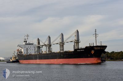
PRAETORIUS
Bulk Carrier

Current Trip
| Time Travelled | 17 days |
|---|---|
| Remaining Time | --- |
| Distance Travelled | 4150.89 nm |
| Remaining Distance | --- |
| AVG Speed | 10.1 Knots |
| MAX Speed | 14.1 Knots |
| AVG Wind | 19.4 knots |
| MAX Wind | 40.7 knots |
| MIN Temp | 4.5°C / 40.1°F |
| MAX Temp | 31.7°C / 89.06°F |
| Draught | 9.1 m |
| Position Received | 5 d ago |
Current Position
| Longitude | --- |
|---|---|
| Latitude | --- |
| Status | Under way using engine |
| Speed | 9.8 Knots |
| Course | 67° |
| Area | North Atlantic Ocean |
| Station | T-AIS |
| Position Received | 5 d ago |
Information
The current position of PRAETORIUS is in North Atlantic Ocean with coordinates 42.94418° / -39.29888° as reported on 2025-03-16 09:54 by AIS to our vessel tracker app. The vessel's current speed is 9.8 Knots and is heading at the port of GENT. The estimated time of arrival as calculated by MyShipTracking vessel tracking app is 2025-03-22 02:00 LT
The vessel PRAETORIUS (IMO: 9470856, MMSI: 538008454) is a Bulk Carrier that was built in 2008 ( 17 years old ). It's sailing under the flag of [MH] Marshall Is.
In this page you can find informations about the vessels current position, last detected port calls, and current voyage information. If the vessels is not in coverage by AIS you will find the latest position.
The current position of PRAETORIUS is detected by our AIS receivers and we are not responsible for the reliability of the data. The last position was recorded while the vessel was in Coverage by the Ais receivers of our vessel tracking app.
The current draught of PRAETORIUS as reported by AIS is 9.1 meters
Weather
| Temperature | 10.9°C / 51.62°F |
|---|---|
| Wind Speed | 17 knots |
| Direction | 318° NW |
| Pressure | 993.8 hPa |
| Humidity | 91.9 % |
| Cloud Coverage | 100 % |


Featured Company
Last Port Calls
| Port | Arrival | Departure | Time In Port |
|---|---|---|---|
| 2025-03-02 09:49 | 2025-03-04 16:41 | 2 d | |
| 2025-02-23 14:04 | 2025-03-01 08:26 | 5 d | |
| 2025-02-12 09:27 | 2025-02-17 16:19 | 5 d | |
| 2025-02-03 10:23 | 2025-02-06 17:59 | 3 d | |
| 2025-01-21 02:40 | 2025-01-29 19:50 | 8 d |
Most Visited Ports (Last year)
| Port | Arrivals | |
|---|---|---|
| 3 | ||
| 2 | ||
| 2 | ||
| 1 | ||
| 1 | ||
| 1 |
Last Trips
| Origin | Departure | Destination | Arrival | Distance | |
|---|---|---|---|---|---|
| 2025-03-01 08:26 | 2025-03-02 09:49 | 122.82 nm | |||
| 2025-02-17 16:19 | 2025-02-23 14:04 | 1476.72 nm | |||
| 2025-02-06 17:59 | 2025-02-12 09:27 | 230.08 nm | |||
| 2025-01-29 19:50 | 2025-02-03 10:23 | 1191.79 nm | |||
| 2024-12-23 12:07 | 2025-01-21 02:40 | 5709.69 nm |
Events
| Time | Event | Details | Position / Dest | Info |
|---|---|---|---|---|
| 2025-03-16 10:03 | Status Changed | Default Under way using engine |
42.95398 / -39.26707
BEGNE
|
Speed: 9.8 kn Course: 67° |
| 2025-03-16 09:54 | OUT of Coverage |
42.94418 / -39.29888
North Atlantic Ocean
BEGNE
|
Speed: 9.8 kn Course: 67° |
|
| 2025-03-16 09:46 | ETA Changed | 2025/03/22 01:00 2025/03/21 12:00 |
42.93593 / -39.32548
BEGNE
|
Speed: 10.2 kn Course: 63° |
| 2025-03-16 09:34 | Change Sea Area | High seas of the North Atlantic Ocean Colombian part of the Caribbean Sea |
42.91943 / -39.37020
North Atlantic Ocean
BEGNE
|
Speed: 10.3 kn Course: 62° |
| 2025-03-16 09:33 | Status Changed | Under way using engine Default |
42.91858 / -39.37242
BEGNE
|
Speed: 10.4 kn Course: 66° |
| 2025-03-16 09:31 | IN Coverage |
42.91943 / -39.37020
North Atlantic Ocean
BEGNE
|
Speed: 10.3 kn Course: 62° |