
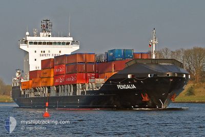
PENGALIA
Container Ship
Current Trip
| Time Travelled | 1 day |
|---|---|
| Remaining Time | 15 h, 30 mins |
| Distance Travelled | 434.50 nm |
| Remaining Distance | 220.61 nm |
| AVG Speed | 15.3 Knots |
| MAX Speed | 16.4 Knots |
| AVG Wind | 11.2 knots |
| MAX Wind | 19.2 knots |
| MIN Temp | 9.7°C / 49.46°F |
| MAX Temp | 16.1°C / 60.98°F |
| Draught | 7.9 m |
| Position Received | Now |
Current Position
| Longitude | --- |
|---|---|
| Latitude | --- |
| Status | Under way using engine |
| Speed | 14.1 Knots |
| Course | 119° |
| Area | Mediterranean Sea - Eastern Basin |
| Station | T-AIS |
| Position Received | Now |
Info
Information
The current position of PENGALIA is in Mediterranean Sea - Eastern Basin with coordinates 36.08597° / 29.21953° as reported on 2025-02-17 20:05 by AIS to our vessel tracker app. The vessel's current speed is 14.1 Knots and is heading at the port of LIMASSOL. The estimated time of arrival as calculated by MyShipTracking vessel tracking app is 2025-02-18 11:36 LT
The vessel PENGALIA (IMO: 9440588, MMSI: 255806347) is a Container Ship that was built in 2008 ( 17 years old ). It's sailing under the flag of [PT] Portugal.
In this page you can find informations about the vessels current position, last detected port calls, and current voyage information. If the vessels is not in coverage by AIS you will find the latest position.
The current position of PENGALIA is detected by our AIS receivers and we are not responsible for the reliability of the data. The last position was recorded while the vessel was in Coverage by the Ais receivers of our vessel tracking app.
The current draught of PENGALIA as reported by AIS is 7.9 meters
Weather
| Temperature | 16°C / 60.8°F |
|---|---|
| Wind Speed | 13 knots |
| Direction | 120° ESE |
| Pressure | 1017 hPa |
| Humidity | 65.7 % |
| Cloud Coverage | 5 % |
Featured Company
Last Port Calls
| Port | Arrival | Departure | Time In Port |
|---|---|---|---|
| 2025-02-14 16:49 | 2025-02-16 15:30 | 1 d | |
| 2025-02-11 13:19 | 2025-02-12 16:24 | 1 d | |
| 2025-02-07 06:26 | 2025-02-09 16:52 | 2 d | |
| 2025-02-04 03:21 | 2025-02-04 20:52 | 17 h | |
| 2025-01-31 13:21 | 2025-02-02 08:07 | 1 d | |
| 2025-01-28 06:14 | 2025-01-28 23:45 | 17 h | |
| 2025-01-23 16:30 | 2025-01-26 11:15 | 2 d | |
| 2025-01-21 03:17 | 2025-01-21 17:07 | 13 h | |
| 2025-01-16 14:40 | 2025-01-19 05:47 | 2 d | |
| 2025-01-14 03:13 | 2025-01-14 16:15 | 13 h |
Most Visited Ports (Last year)
| Port | Arrivals | |
|---|---|---|
| 58 | ||
| 51 |
Last Trips
| Origin | Departure | Destination | Arrival | Distance | |
|---|---|---|---|---|---|
| 2025-02-12 18:24 | 2025-02-14 18:49 | 661.15 nm | |||
| 2025-02-09 18:52 | 2025-02-11 15:19 | 660.89 nm | |||
| 2025-02-04 22:52 | 2025-02-07 08:26 | 678.38 nm | |||
| 2025-02-02 10:07 | 2025-02-04 05:21 | 659.69 nm | |||
| 2025-01-29 01:45 | 2025-01-31 15:21 | 660.76 nm | |||
| 2025-01-26 13:15 | 2025-01-28 08:14 | 656.23 nm | |||
| 2025-01-21 19:07 | 2025-01-23 18:30 | 655.89 nm | |||
| 2025-01-19 07:47 | 2025-01-21 05:17 | 659.89 nm | |||
| 2025-01-14 18:15 | 2025-01-16 16:40 | 658.34 nm | |||
| 2025-01-11 16:15 | 2025-01-14 05:13 | 660.21 nm |
Events
| Time | Event | Details | Position / Dest | Info |
|---|---|---|---|---|
| 2025-02-17 17:46 | Change Sea Area | Turkish part of the Mediterranean Sea - Eastern Basin Greek part of the Mediterranean Sea - Eastern Basin |
36.32544 / 28.61694
Mediterranean Sea - Eastern Basin
CYLMS
|
Speed: 14.1 kn Course: 116.7° |
| 2025-02-17 16:18 | Change Sea Area | Greek part of the Mediterranean Sea - Eastern Basin Greek part of the Aegean Sea |
36.48619 / 28.22458
Mediterranean Sea - Eastern Basin
CYLMS
|
Speed: 14.4 kn Course: 110.4° |
| 2025-02-17 15:43 | Change Sea Area | Greek part of the Aegean Sea Turkish part of the Aegean Sea |
36.48483 / 28.04681
Aegean Sea
CYLMS
|
Speed: 14.8 kn Course: 81.9° |
| 2025-02-17 15:28 | Change Sea Area | Turkish part of the Aegean Sea Greek part of the Aegean Sea |
36.47723 / 27.97044
Aegean Sea
CYLMS
|
Speed: 14.4 kn Course: 83.2° |
| 2025-02-17 09:55 | ETA Changed | 2025/02/18 11:30 2025/02/18 12:00 |
37.01984 / 26.53561
CYLMS
|
Speed: 15.3 kn Course: 140° |
| 2025-02-17 03:30 | Status Changed | Under way using engine Default |
38.14125 / 25.04654
CYLMS
|
Speed: 15.7 kn Course: 133° |
| 2025-02-17 03:14 | Status Changed | Default Under way using engine |
38.18854 / 24.98347
CYLMS
|
Speed: 15.6 kn Course: 133.5° |
| 2025-02-17 03:02 | Status Changed | Under way using engine Default |
38.22573 / 24.93219
CYLMS
|
Speed: 15.6 kn Course: 132° |
| 2025-02-17 03:02 | IN Coverage |
38.22573 / 24.93219
Aegean Sea
CYLMS
|
Speed: 15.5 kn Course: 133.6° |
|
| 2025-02-17 01:44 | OUT of Coverage |
38.45818 / 24.61870
Aegean Sea
CYLMS
|
Speed: 16.2 kn Course: 129.4° |