
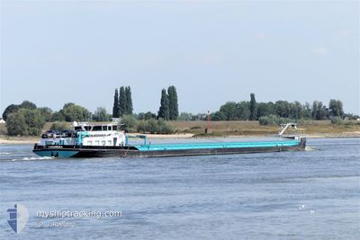
PANAMERA
Cargo
Current Trip
PANAMERA is out of coverage. Learn how you can join the community and extend the coverage to your area by clicking here!
| Time Travelled | 16 h, 24 mins |
|---|---|
| Remaining Time | --- |
| Distance Travelled | 25.14 nm |
| Remaining Distance | --- |
| AVG Speed | 4.6 Knots |
| MAX Speed | 5.5 Knots |
| AVG Wind | 6.5 knots |
| MAX Wind | 8 knots |
| MIN Temp | 6.2°C / 43.16°F |
| MAX Temp | 10.7°C / 51.26°F |
| Draught | 0 m |
| Position Received | 8 h, 53 m ago |
Current Position
| Longitude | --- |
|---|---|
| Latitude | --- |
| Status | Under way using engine |
| Speed | 4.2 Knots |
| Course | 239.1° |
| Area | North Sea |
| Station | T-AIS |
| Position Received | 8 h, 53 m ago |
Info
info
Information
The current position of PANAMERA is in North Sea with coordinates 50.75711° / 3.44487° as reported on 2025-12-11 21:30 by AIS to our vessel tracker app. The vessel's current speed is 4.2 Knots
The vessel PANAMERA (MMSI: 226017120) is a Cargo It's sailing under the flag of [FR] France.
In this page you can find informations about the vessels current position, last detected port calls, and current voyage information. If the vessels is not in coverage by AIS you will find the latest position.
The current position of PANAMERA is detected by our AIS receivers and we are not responsible for the reliability of the data. The last position was recorded while the vessel was in Coverage by the Ais receivers of our vessel tracking app.
Weather
| Temperature | 6.5°C / 43.7°F |
|---|---|
| Wind Speed | 5 knots |
| Direction | 149° SSE |
| Pressure | 1019.6 hPa |
| Humidity | 94.9 % |
| Cloud Coverage | 100 % |
Featured Company
Limited time offer - Install a base station receiver to your area and list your company on MyShipTracking Free forever!
Last Port Calls
| Port | Arrival | Departure | Time In Port |
|---|---|---|---|
| 2025-12-10 06:44 | 2025-12-11 13:59 | 1 d | |
| 2025-12-04 23:30 | 2025-12-05 14:08 | 14 h | |
| 2025-12-02 14:04 | 2025-12-03 14:32 | 1 d | |
| 2025-11-25 12:04 | 2025-11-26 13:40 | 1 d | |
| 2025-11-20 23:18 | 2025-11-21 13:33 | 14 h | |
| 2025-11-18 11:52 | 2025-11-19 13:55 | 1 d | |
| 2025-11-11 14:27 | 2025-11-13 20:31 | 2 d | |
| 2025-11-04 19:26 | 2025-11-04 21:56 | 2 h | |
| 2025-11-03 22:04 | 2025-11-04 15:44 | 17 h | |
| 2025-11-03 18:14 | 2025-11-03 19:51 | 1 h |
Most Visited Ports (Last year)
| Port | Arrivals | |
|---|---|---|
| 71 | ||
| 7 | ||
| 5 | ||
| 4 | ||
| 4 | ||
| 3 |
Last Trips
| Origin | Departure | Destination | Arrival | Distance | |
|---|---|---|---|---|---|
| 2025-12-05 15:08 | 2025-12-10 07:44 | 51.22 nm | |||
| 2025-12-03 15:32 | 2025-12-05 00:30 | 57.02 nm | |||
| 2025-11-26 14:40 | 2025-12-02 15:04 | 62.35 nm | |||
| 2025-11-21 14:33 | 2025-11-25 13:04 | 62.10 nm | |||
| 2025-11-19 14:55 | 2025-11-21 00:18 | 61.18 nm | |||
| 2025-11-13 21:31 | 2025-11-18 12:52 | 49.88 nm | |||
| 2025-11-04 22:56 | 2025-11-11 15:27 | 59.17 nm | |||
| 2025-11-04 16:44 | 2025-11-04 20:26 | 32.61 nm | |||
| 2025-11-03 20:51 | 2025-11-03 23:04 | 21.98 nm | |||
| 2025-11-03 17:39 | 2025-11-03 19:14 | 10.18 nm |
Events
| Time | Event | Details | Position / Dest | Info |
|---|---|---|---|---|
| 2025-12-11 21:30 | OUT of Coverage |
50.75711 / 3.44487
North Sea
ANTOING
|
Speed: 4.2 kn Course: 239.1° |
|
| 2025-12-11 19:13 | START Moving | 8.22 nm, North East of AVELGEM |
50.84715 / 3.61461
ANTOING
|
Speed: 4.2 kn Course: 218.5° |
| 2025-12-11 18:58 | STOP Moving | 8.49 nm, North East of AVELGEM |
50.85074 / 3.61906
ANTOING
|
Speed: 0.3 kn Course: 511° |
| 2025-12-11 17:42 | START Moving | 7.02 nm, South East of DEINZE |
50.91607 / 3.66860
ANTOING
|
Speed: 3.2 kn Course: 126.7° |
| 2025-12-11 17:17 | Status Changed | Under way using engine Moored |
50.91862 / 3.66256
ANTOING
|
Speed: Course: 511° |
| 2025-12-11 16:34 | Status Changed | Moored Under way using engine |
50.91940 / 3.66097
ANTOING
|
Speed: Course: 511° |
| 2025-12-11 16:17 | STOP Moving | 6.67 nm, South East of DEINZE |
50.91957 / 3.66107
ANTOING
|
Speed: 0.1 kn Course: 511° |
| 2025-12-11 16:09 | ETA Changed | 2025/12/12 15:48 2025/12/12 09:47 |
50.92270 / 3.65820
ANTOING
|
Speed: 3.2 kn Course: 168.8° |
| 2025-12-11 15:40 | Status Changed | Under way using engine Default |
50.95414 / 3.65124
ANTOING
|
Speed: 4.4 kn Course: -1° |
| 2025-12-11 15:19 | Status Changed | Default Under way using engine |
50.95816 / 3.68610
ANTOING
|
Speed: 4.5 kn Course: 228.1° |