

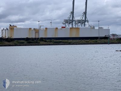
PAGANELLA
Vehicles Carrier

Current Trip
| Time Travelled | 8 days |
|---|---|
| Remaining Time | --- |
| Distance Travelled | 2960.53 nm |
| Remaining Distance | --- |
| AVG Speed | 15.1 Knots |
| MAX Speed | 17.8 Knots |
| AVG Wind | 19 knots |
| MAX Wind | 32.3 knots |
| MIN Temp | -0.1°C / 31.82°F |
| MAX Temp | 11.2°C / 52.16°F |
| Draught | 8.7 m |
| Position Received | 5 d ago |
Current Position
| Longitude | --- |
|---|---|
| Latitude | --- |
| Status | Under way using engine |
| Speed | 16.2 Knots |
| Course | 49.9° |
| Area | North Pacific Ocean |
| Station | T-AIS |
| Position Received | 5 d ago |
Information
The current position of PAGANELLA is in North Pacific Ocean with coordinates 35.19828° / 141.28314° as reported on 2025-02-24 03:05 by AIS to our vessel tracker app. The vessel's current speed is 16.2 Knots and is heading at the port of ANNACIS ISLAND. The estimated time of arrival as calculated by MyShipTracking vessel tracking app is 2025-03-08 00:00 LT
The vessel PAGANELLA (IMO: 9427926, MMSI: 538090648) is a Vehicles Carrier that was built in 2009 ( 16 years old ). It's sailing under the flag of [MH] Marshall Is.
In this page you can find informations about the vessels current position, last detected port calls, and current voyage information. If the vessels is not in coverage by AIS you will find the latest position.
The current position of PAGANELLA is detected by our AIS receivers and we are not responsible for the reliability of the data. The last position was recorded while the vessel was in Coverage by the Ais receivers of our vessel tracking app.
The current draught of PAGANELLA as reported by AIS is 8.7 meters
Weather
| Temperature | 1.4°C / 34.52°F |
|---|---|
| Wind Speed | 26 knots |
| Direction | 9° N |
| Pressure | 997.1 hPa |
| Humidity | 69.2 % |
| Cloud Coverage | 100 % |


Featured Company
Last Port Calls
| Port | Arrival | Departure | Time In Port |
|---|---|---|---|
| 2025-02-18 15:34 | 2025-02-21 15:26 | 2 d | |
| 2025-02-17 11:00 | 2025-02-17 15:20 | 4 h | |
| 2025-02-01 16:18 | 2025-02-02 08:08 | 15 h | |
| 2025-01-29 11:22 | 2025-01-31 03:02 | 1 d | |
| 2025-01-25 04:07 | 2025-01-26 04:24 | 1 d | |
| 2025-01-08 06:57 | 2025-01-09 07:05 | 1 d |
Last Trips
| Origin | Departure | Destination | Arrival | Distance | |
|---|---|---|---|---|---|
| 2025-02-17 15:20 | 2025-02-18 15:34 | 185.42 nm | |||
| 2025-02-02 08:08 | 2025-02-17 11:00 | 5249.67 nm | |||
| 2025-01-31 03:02 | 2025-02-01 16:18 | 562.21 nm | |||
| 2025-01-26 04:24 | 2025-01-29 11:22 | 740.36 nm | |||
| 2025-01-09 07:05 | 2025-01-25 04:07 | 4190.09 nm | |||
| 2024-12-18 22:40 | 2025-01-08 06:57 | 5449.01 nm |
Events
| Time | Event | Details | Position / Dest | Info |
|---|---|---|---|---|
| 2025-02-24 03:16 | Status Changed | Default Under way using engine |
35.23141 / 141.32880
KRUSN>CANWE
|
Speed: 16.2 kn Course: 49.9° |
| 2025-02-24 03:05 | OUT of Coverage |
35.19828 / 141.28314
North Pacific Ocean
KRUSN>CANWE
|
Speed: 16.2 kn Course: 49.9° |
|
| 2025-02-24 03:04 | Status Changed | Under way using engine Default |
35.19734 / 141.28182
KRUSN>CANWE
|
Speed: 16.5 kn Course: 47° |
| 2025-02-24 02:58 | Status Changed | Default Under way using engine |
35.17860 / 141.25619
KRUSN>CANWE
|
Speed: 17.2 kn Course: 47.7° |
| 2025-02-24 00:07 | Draught Changed | 8.7 7.8 |
34.66907 / 140.53576
KRUSN>CANWE
|
Speed: 14.3 kn Course: 45.9° |
| 2025-02-24 00:07 | Destination Changed | KRUSN>CANWE KRMAS>KRUSN |
34.66907 / 140.53576
KRUSN>CANWE
|
Speed: 14.3 kn Course: 45.9° |
| 2025-02-24 00:07 | ETA Changed | 2025/03/08 08:00 2025/02/18 21:15 |
34.66907 / 140.53576
KRUSN>CANWE
|
Speed: 14.3 kn Course: 45.9° |
| 2025-02-23 23:10 | Status Changed | Under way using engine Default |
34.51478 / 140.33783
KRMAS>KRUSN
|
Speed: 15.1 kn Course: 65° |
| 2025-02-23 23:06 | Status Changed | Default Under way using engine |
34.50686 / 140.31767
KRMAS>KRUSN
|
Speed: 15.2 kn Course: 62° |
| 2025-02-23 22:52 | Change Sea Area | Japanese part of the North Pacific Ocean Japanese part of the Japan Sea |
34.47870 / 140.25811
North Pacific Ocean
|
Speed: 15.3 kn Course: 49.9° |