
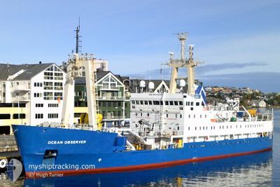
OCEAN OBSERVER
Research/Survey Vessel
Current Trip
SURVAY OPS.KEEP 1NM
| Time Travelled | 7 days |
|---|---|
| Remaining Time | --- |
| Distance Travelled | 199.11 nm |
| Remaining Distance | --- |
| AVG Speed | 5.3 Knots |
| MAX Speed | 10.5 Knots |
| AVG Wind | 16 knots |
| MAX Wind | 28.8 knots |
| MIN Temp | 5.9°C / 42.62°F |
| MAX Temp | 13.5°C / 56.3°F |
| Draught | 4.9 m |
| Position Received | 1 m ago |
Current Position
| Longitude | -3.55634° |
|---|---|
| Latitude | 53.76936° |
| Status | Restricted manoeuverability |
| Speed | |
| Course | --- |
| Area | Irish Sea and St. George's Channel |
| Station | T-AIS |
| Position Received | 1 m ago |
Info
Information
The current position of OCEAN OBSERVER is in Irish Sea and St. George's Channel with coordinates 53.76936° / -3.55634° as reported on 2024-05-03 13:40 by AIS to our vessel tracker app. The vessel's current speed is 0 Knots
The vessel OCEAN OBSERVER (IMO: 8511275, MMSI: 232217000) is a Research/Survey Vessel that was built in 1987 ( 37 years old ). It's sailing under the flag of [GB] United Kingdom.
In this page you can find informations about the vessels current position, last detected port calls, and current voyage information. If the vessels is not in coverage by AIS you will find the latest position.
The current position of OCEAN OBSERVER is detected by our AIS receivers and we are not responsible for the reliability of the data. The last position was recorded while the vessel was in Coverage by the Ais receivers of our vessel tracking app.
The current draught of OCEAN OBSERVER as reported by AIS is 4.9 meters
Weather
| Temperature | 10.6°C / 51.08°F |
|---|---|
| Wind Speed | 8 knots |
| Direction | 293° WNW |
| Pressure | 1007 hPa |
| Humidity | 90.1 % |
| Cloud Coverage | 100 % |
Featured Company
Last Port Calls
| Port | Arrival | Departure | Time In Port |
|---|---|---|---|
| 2024-04-25 07:01 | 2024-04-26 08:07 | 1 d | |
| 2024-04-10 02:52 | 2024-04-12 08:47 | 2 d | |
| 2024-04-03 19:26 | 2024-04-05 11:43 | 1 d | |
| 2024-04-01 20:22 | 2024-04-03 19:09 | 1 d | |
| 2024-03-23 01:11 | 2024-03-27 04:10 | 4 d | |
| 2024-03-09 12:12 | 2024-03-11 14:03 | 2 d |
Most Visited Ports (Last year)
| Port | Arrivals | |
|---|---|---|
| 4 | ||
| 4 | ||
| 4 | ||
| 4 | ||
| 3 | ||
| 2 |
Last Trips
| Origin | Departure | Destination | Arrival | Distance | |
|---|---|---|---|---|---|
| 2024-04-12 09:47 | 2024-04-25 08:01 | 1048.35 nm | |||
| 2024-04-05 12:43 | 2024-04-10 03:52 | 684.51 nm | |||
| 2024-04-03 20:09 | 2024-04-03 20:26 | 0.43 nm | |||
| 2024-03-27 04:10 | 2024-04-01 21:22 | 448.08 nm | |||
| 2024-03-11 14:03 | 2024-03-23 01:11 | 662.22 nm |
Events
| Time | Event | Details | Position / Dest | Info |
|---|---|---|---|---|
| 2024-05-03 13:03 | Status Changed | Restricted manoeuverability Default |
53.76928 / -3.55667
SURVAY OPS.KEEP 1NM
|
Speed: Course: -1° |
| 2024-05-03 12:46 | Status Changed | Default Restricted manoeuverability |
53.76927 / -3.55686
SURVAY OPS.KEEP 1NM
|
Speed: Course: 511° |
| 2024-05-03 12:25 | STOP Moving | 18.71 nm, North of LIVERPOOL ANCH |
53.76952 / -3.55740
SURVAY OPS.KEEP 1NM
|
Speed: Course: 511° |
| 2024-05-03 12:16 | START Moving | 18.84 nm, North of LIVERPOOL ANCH |
53.77046 / -3.56405
SURVAY OPS.KEEP 1NM
|
Speed: 3.9 kn Course: 133.6° |
| 2024-05-03 12:03 | Status Changed | Restricted manoeuverability Default |
53.77271 / -3.56959
SURVAY OPS.KEEP 1NM
|
Speed: 0.1 kn Course: -1° |
| 2024-05-03 11:58 | Status Changed | Default Restricted manoeuverability |
53.77277 / -3.56959
SURVAY OPS.KEEP 1NM
|
Speed: Course: 511° |
| 2024-05-03 11:51 | Status Changed | Restricted manoeuverability Default |
53.77273 / -3.56958
SURVAY OPS.KEEP 1NM
|
Speed: 0.1 kn Course: -1° |
| 2024-05-03 11:42 | Status Changed | Default Restricted manoeuverability |
53.77271 / -3.56956
SURVAY OPS.KEEP 1NM
|
Speed: 0.1 kn Course: 511° |
| 2024-05-03 11:34 | Status Changed | Restricted manoeuverability Default |
53.77276 / -3.56960
SURVAY OPS.KEEP 1NM
|
Speed: Course: -1° |
| 2024-05-03 11:10 | Status Changed | Default Restricted manoeuverability |
53.77264 / -3.56964
SURVAY OPS.KEEP 1NM
|
Speed: Course: 511° |