
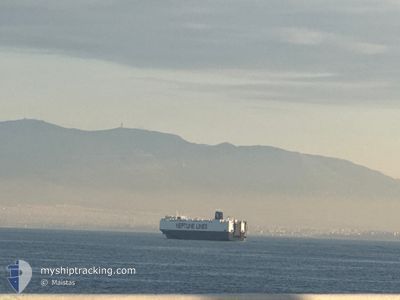
NEPTUNE ITHAKI
Vehicles Carrier
Current Trip
| Time Travelled | 1 day |
|---|---|
| Remaining Time | -8 mins |
| Distance Travelled | 398.49 nm |
| Remaining Distance | 6.06 nm |
| AVG Speed | 13.6 Knots |
| MAX Speed | 18.3 Knots |
| AVG Wind | 6.3 knots |
| MAX Wind | 16 knots |
| MIN Temp | 9°C / 48.2°F |
| MAX Temp | 16°C / 60.8°F |
| Draught | 8.7 m |
| Position Received | 1 m ago |
Current Position
| Longitude | --- |
|---|---|
| Latitude | --- |
| Status | Under way using engine |
| Speed | 2.2 Knots |
| Course | 350° |
| Area | Aegean Sea |
| Station | T-AIS |
| Position Received | 1 m ago |
Info
Information
The current position of NEPTUNE ITHAKI is in Aegean Sea with coordinates 37.88492° / 23.52906° as reported on 2025-12-12 09:24 by AIS to our vessel tracker app. The vessel's current speed is 2.2 Knots and is heading at the port of PIRAEUS. The estimated time of arrival as calculated by MyShipTracking vessel tracking app is 2025-12-12 11:18 LT
The vessel NEPTUNE ITHAKI (IMO: 9440083, MMSI: 215587000) is a Vehicles Carrier that was built in 2010 ( 15 years old ). It's sailing under the flag of [MT] Malta.
In this page you can find informations about the vessels current position, last detected port calls, and current voyage information. If the vessels is not in coverage by AIS you will find the latest position.
The current position of NEPTUNE ITHAKI is detected by our AIS receivers and we are not responsible for the reliability of the data. The last position was recorded while the vessel was in Coverage by the Ais receivers of our vessel tracking app.
The current draught of NEPTUNE ITHAKI as reported by AIS is 8.7 meters
Weather
| Temperature | 14.9°C / 58.82°F |
|---|---|
| Wind Speed | 2 knots |
| Direction | 358° N |
| Pressure | 1020.1 hPa |
| Humidity | 53.3 % |
| Cloud Coverage | 1 % |
Featured Company
Last Port Calls
| Port | Arrival | Departure | Time In Port |
|---|---|---|---|
| 2025-12-10 13:33 | 2025-12-11 08:50 | 19 h | |
| 2025-12-10 03:32 | 2025-12-10 12:40 | 9 h | |
| 2025-12-09 06:42 | 2025-12-09 22:18 | 15 h | |
| 2025-12-08 13:51 | 2025-12-09 05:29 | 15 h | |
| 2025-12-06 07:16 | 2025-12-07 09:55 | 1 d | |
| 2025-12-01 20:51 | 2025-12-03 21:27 | 2 d | |
| 2025-11-28 09:51 | 2025-11-28 18:04 | 8 h | |
| 2025-11-26 19:25 | 2025-11-27 12:57 | 17 h | |
| 2025-11-25 12:21 | 2025-11-26 18:48 | 1 d | |
| 2025-11-23 08:32 | 2025-11-25 11:10 | 2 d |
Last Trips
| Origin | Departure | Destination | Arrival | Distance | |
|---|---|---|---|---|---|
| 2025-12-10 12:40 | 2025-12-10 13:33 | 6.52 nm | |||
| 2025-12-09 22:18 | 2025-12-10 03:32 | 13.22 nm | |||
| 2025-12-09 05:29 | 2025-12-09 06:42 | 13.18 nm | |||
| 2025-12-07 09:55 | 2025-12-08 13:51 | 386.41 nm | |||
| 2025-12-03 21:27 | 2025-12-06 07:16 | 874.59 nm | |||
| 2025-11-28 18:04 | 2025-12-01 20:51 | 1173.27 nm | |||
| 2025-11-27 12:57 | 2025-11-28 09:51 | 82.13 nm | |||
| 2025-11-26 18:48 | 2025-11-26 19:25 | 4.88 nm | |||
| 2025-11-25 11:10 | 2025-11-25 12:21 | 13.54 nm | |||
| 2025-11-18 08:27 | 2025-11-23 08:32 | 1207.11 nm |
Events
| Time | Event | Details | Position / Dest | Info |
|---|---|---|---|---|
| 2025-12-12 08:22 | ETA Changed | 2025/12/12 09:00 2026/01/01 09:00 |
37.80291 / 23.66753
GRPIR
|
Speed: 12.2 kn Course: 332.2° |
| 2025-12-12 08:11 | ETA Changed | 2026/01/01 09:00 2025/12/12 09:00 |
37.76917 / 23.69002
GRPIR
|
Speed: 12.3 kn Course: 331.6° |
| 2025-12-12 06:45 | Status Changed | Under way using engine Default |
37.61993 / 23.99264
GRPIR
|
Speed: 12.7 kn Course: 274° |
| 2025-12-12 06:24 | Status Changed | Default Under way using engine |
37.61394 / 24.08309
GRPIR
|
Speed: 12.5 kn Course: 247.2° |
| 2025-12-12 06:18 | Status Changed | Under way using engine Default |
37.61903 / 24.11010
GRPIR
|
Speed: 12.7 kn Course: 227° |
| 2025-12-12 05:52 | Status Changed | Default Under way using engine |
37.68153 / 24.19830
GRPIR
|
Speed: 12.6 kn Course: 230° |
| 2025-12-12 04:28 | ETA Changed | 2025/12/12 09:00 2025/12/12 15:00 |
37.88319 / 24.49235
GRPIR
|
Speed: 13.7 kn Course: 228.9° |
| 2025-12-12 04:10 | Status Changed | Under way using engine Default |
37.93071 / 24.55335
GRPIR
|
Speed: 13 kn Course: 209° |
| 2025-12-12 04:04 | Status Changed | Default Under way using engine |
37.94833 / 24.56667
GRPIR
|
Speed: 13.9 kn Course: 211.9° |
| 2025-12-12 02:54 | Status Changed | Under way using engine Default |
38.18182 / 24.73568
GRPIR
|
Speed: 13 kn Course: 208° |