
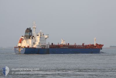
NARGIS
Oil/Chemical Tanker
Current Trip
RU TAM
| Time Travelled | --- |
|---|---|
| Remaining Time | --- |
| Distance Travelled | --- |
| Remaining Distance | --- |
| AVG Speed | --- |
| MAX Speed | --- |
| AVG Wind | --- |
| MAX Wind | --- |
| MIN Temp | --- |
| MAX Temp | --- |
| Draught | 7 m |
| Position Received | 7 d ago |
Current Position
| Longitude | 29.41475° |
|---|---|
| Latitude | 41.40803° |
| Status | Under way using engine |
| Speed | 13.5 Knots |
| Course | 55.5° |
| Area | Black Sea |
| Station | T-AIS |
| Position Received | 7 d ago |
Info
Information
The current position of NARGIS is in Black Sea with coordinates 41.40803° / 29.41475° as reported on 2024-04-22 03:48 by AIS to our vessel tracker app. The vessel's current speed is 13.5 Knots
The vessel NARGIS (IMO: 9353125, MMSI: 626283000) is a Oil/Chemical Tanker that was built in 2008 ( 16 years old ). It's sailing under the flag of [GA] Gabon.
In this page you can find informations about the vessels current position, last detected port calls, and current voyage information. If the vessels is not in coverage by AIS you will find the latest position.
The current position of NARGIS is detected by our AIS receivers and we are not responsible for the reliability of the data. The last position was recorded while the vessel was in Coverage by the Ais receivers of our vessel tracking app.
The current draught of NARGIS as reported by AIS is 7 meters
Weather
| Temperature | 15.9°C / 60.62°F |
|---|---|
| Wind Speed | 13 knots |
| Direction | 34° NE |
| Pressure | 1018.5 hPa |
| Humidity | 72.2 % |
| Cloud Coverage | 100 % |
Featured Company
Last Port Calls
| Port | Arrival | Departure | Time In Port |
|---|---|---|---|
| 2024-04-23 12:23 | |||
| 2024-03-29 03:24 |
Most Visited Ports (Last year)
| Port | Arrivals | |
|---|---|---|
| 4 | ||
| 4 | ||
| 4 | ||
| 1 |
Last Trips
| Origin | Departure | Destination | Arrival | Distance |
|---|
Events
| Time | Event | Details | Position / Dest | Info |
|---|---|---|---|---|
| 2024-04-23 12:23 | PORT ARRIVAL |
|
45.11614 / 36.66440
[RU] TAMAN
|
Speed: 11 kn Course: 359° |
| 2024-04-22 03:55 | Status Changed | Default Under way using engine |
41.42240 / 29.44258
RU TAM
|
Speed: 13.5 kn Course: 55.5° |
| 2024-04-22 03:48 | Status Changed | Under way using engine Default |
41.40803 / 29.41475
RU TAM
|
Speed: 13.4 kn Course: 55° |
| 2024-04-22 03:48 | OUT of Coverage |
41.40803 / 29.41475
Black Sea
RU TAM
|
Speed: 13.5 kn Course: 55.5° |
|
| 2024-04-22 03:38 | Status Changed | Default Under way using engine |
41.38661 / 29.37376
RU TAM
|
Speed: 13.3 kn Course: 55.2° |
| 2024-04-22 02:37 | Change Sea Area | Turkish part of the Black Sea Turkish part of the Sea of Marmara |
41.23481 / 29.14944
Black Sea
RU TAM
|
Speed: 12.7 kn Course: 38.7° |
| 2024-04-21 21:42 | START Moving | 16.22 nm, South West of AMBARLI |
40.71860 / 28.51277
RU TAM
|
Speed: 3.4 kn Course: 323° |
| 2024-04-21 21:04 | Status Changed | Under way using engine Default |
40.71197 / 28.51645
RU TAM
|
Speed: 0.3 kn Course: -1° |
| 2024-04-21 20:59 | Status Changed | Default Under way using engine |
40.71165 / 28.51679
RU TAM
|
Speed: 0.2 kn Course: 511° |
| 2024-04-21 19:54 | Status Changed | Under way using engine Default |
40.70882 / 28.52064
RU TAM
|
Speed: 0.4 kn Course: -1° |