
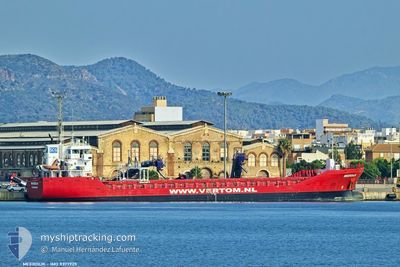
MV MEERDIJK
General Cargo
Current Trip
| Time Travelled | 11 days |
|---|---|
| Remaining Time | --- |
| Distance Travelled | 2727.75 nm |
| Remaining Distance | --- |
| AVG Speed | 9.7 Knots |
| MAX Speed | 13.7 Knots |
| AVG Wind | 11.8 knots |
| MAX Wind | 25 knots |
| MIN Temp | 1.3°C / 34.34°F |
| MAX Temp | 15.9°C / 60.62°F |
| Draught | 6.2 m |
| Position Received | 1 d ago |
Current Position
| Longitude | --- |
|---|---|
| Latitude | --- |
| Status | Under way using engine |
| Speed | 10.9 Knots |
| Course | 118.9° |
| Area | Mediterranean Sea - Eastern Basin |
| Station | T-AIS |
| Position Received | 1 d ago |
Info
Information
The current position of MV MEERDIJK is in Mediterranean Sea - Eastern Basin with coordinates 36.62891° / 14.64732° as reported on 2025-01-21 14:06 by AIS to our vessel tracker app. The vessel's current speed is 10.9 Knots and is heading at the port of VARNA. The estimated time of arrival as calculated by MyShipTracking vessel tracking app is 2025-01-25 22:00 LT
The vessel MV MEERDIJK (IMO: 9377925, MMSI: 245682000) is a General Cargo that was built in 2010 ( 15 years old ). It's sailing under the flag of [NL] Netherlands.
In this page you can find informations about the vessels current position, last detected port calls, and current voyage information. If the vessels is not in coverage by AIS you will find the latest position.
The current position of MV MEERDIJK is detected by our AIS receivers and we are not responsible for the reliability of the data. The last position was recorded while the vessel was in Coverage by the Ais receivers of our vessel tracking app.
The current draught of MV MEERDIJK as reported by AIS is 6.2 meters
Weather
| Temperature | 15.8°C / 60.44°F |
|---|---|
| Wind Speed | 13 knots |
| Direction | 293° WNW |
| Pressure | 1021 hPa |
| Humidity | 68.4 % |
| Cloud Coverage | 6 % |
Featured Company
Last Port Calls
| Port | Arrival | Departure | Time In Port |
|---|---|---|---|
| 2025-01-08 19:23 | 2025-01-11 04:29 | 2 d | |
| 2025-01-08 04:54 | 2025-01-08 19:16 | 14 h | |
| 2025-01-07 01:36 | 2025-01-07 01:59 | 23 m | |
| 2025-01-02 13:39 | 2025-01-07 00:43 | 4 d | |
| 2025-01-02 11:37 | 2025-01-02 12:47 | 1 h | |
| 2024-12-29 06:13 | 2024-12-31 13:51 | 2 d | |
| 2024-12-24 15:30 | 2024-12-29 06:07 | 4 d | |
| 2024-12-20 09:52 | 2024-12-22 14:57 | 2 d | |
| 2024-12-14 10:08 | 2024-12-16 23:54 | 2 d | |
| 2024-12-11 08:02 | 2024-12-13 07:44 | 1 d |
Last Trips
| Origin | Departure | Destination | Arrival | Distance | |
|---|---|---|---|---|---|
| 2025-01-08 19:16 | 2025-01-08 19:23 | 0.10 nm | |||
| 2025-01-07 01:59 | 2025-01-08 04:54 | 248.94 nm | |||
| 2025-01-07 00:43 | 2025-01-07 01:36 | 5.50 nm | |||
| 2025-01-02 12:47 | 2025-01-02 13:39 | 4.76 nm | |||
| 2024-12-31 13:51 | 2025-01-02 11:37 | 253.48 nm | |||
| 2024-12-29 06:07 | 2024-12-29 06:13 | 0.58 nm | |||
| 2024-12-22 14:57 | 2024-12-24 15:30 | 214.89 nm | |||
| 2024-12-16 23:54 | 2024-12-20 09:52 | 518.05 nm | |||
| 2024-12-13 07:44 | 2024-12-14 10:08 | 293.58 nm | |||
| 2024-12-09 04:23 | 2024-12-11 08:02 | 357.84 nm |
Events
| Time | Event | Details | Position / Dest | Info |
|---|---|---|---|---|
| 2025-01-21 14:26 | Status Changed | Default Under way using engine |
36.60092 / 14.71442
BGVAR
|
Speed: 10.9 kn Course: 118.9° |
| 2025-01-21 14:06 | OUT of Coverage |
36.62891 / 14.64732
Mediterranean Sea - Eastern Basin
BGVAR
|
Speed: 10.9 kn Course: 118.9° |
|
| 2025-01-21 11:09 | Draught Changed | 6.2 6.5 |
36.85832 / 14.06833
BGVAR
|
Speed: 10 kn Course: 118.4° |
| 2025-01-21 11:09 | ETA Changed | 2025/01/25 20:00 2025/01/25 10:00 |
36.85832 / 14.06833
BGVAR
|
Speed: 10 kn Course: 118.4° |
| 2025-01-21 10:52 | Status Changed | Under way using engine Default |
36.87938 / 14.01530
BGVAR
|
Speed: 10 kn Course: 115° |
| 2025-01-21 10:45 | Status Changed | Default Under way using engine |
36.88779 / 13.99315
BGVAR
|
Speed: 10 kn Course: 114.8° |
| 2025-01-21 10:10 | Detected in Sea | Italian part of the Mediterranean Sea - Eastern Basin |
36.92921 / 13.88135
Mediterranean Sea - Eastern Basin
BGVAR
|
Speed: 10.1 kn Course: 112.5° |
| 2025-01-21 10:10 | Status Changed | Under way using engine Default |
36.92921 / 13.88135
BGVAR
|
Speed: 10 kn Course: 112° |
| 2025-01-21 10:00 | IN Coverage |
36.92921 / 13.88135
Mediterranean Sea - Eastern Basin
BGVAR
|
Speed: 10.1 kn Course: 112.5° |
|
| 2025-01-17 05:19 | OUT of Coverage |
36.07342 / -4.68313
Alboran Sea
BGVAR
|
Speed: 10.5 kn Course: 83° |